Ataliva facts for kids
Quick facts for kids
Ataliva
|
|
|---|---|
|
Commune
|
|

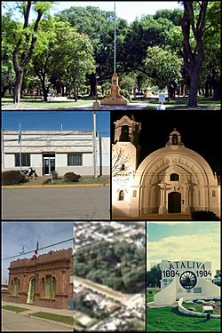
Clockwise, from top: Plaza 25 de Mayo, Commune of Ataliva, San Roque Church, the Italian Society, an aerial view of Ataliva, Centennial Monument
|
|

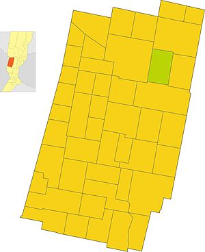
The commune of Ataliva in the Castellanos Department
|
|
| Country | |
| Province | Santa Fe |
| Department | Castellanos |
| Area | |
| • Total | 155 km2 (60 sq mi) |
| Elevation | 89 m (292 ft) |
| Population
(2010)
|
|
| • Total | 2,065 |
| • Density | 13.32/km2 (34.5/sq mi) |
| Time zone | UTC−03:00 |
| Postal code |
S2307
|
| Area code(s) | 03493 |
Ataliva is a town in the Santa Fe province of Argentina. It is located in the Castellanos department. The town was founded in 1884. Many of its first residents came from Italy.
Ataliva started as a farming community. It still focuses on agriculture and raising animals today. The town is also known as the "chorizo capital." This is because of its delicious handmade chorizo sausages.
The town was founded by Ataliva Roca in 1884. Its first location was near an old railroad station. But it was moved about one kilometer to its current spot. This new location was safer and better.
Ataliva has many low houses and wide streets. You can see lots of different trees and plants. This makes the town look very green and inviting.
Contents
Geography
Where is Ataliva Located?
Ataliva is in South America. It is in the central-west part of the Santa Fe province. The town is located at 31° south latitude and 61° west longitude.
It is easy to reach Ataliva by road. Provincial routes 13 and 62 S pass through it. National Route 34 is only 5 kilometers away.
Ataliva is 107 kilometers from Santa Fe City. It is 263 kilometers from Rosario. The city of Córdoba is 316 kilometers away. Argentina's capital, Buenos Aires, is 557 kilometers from Ataliva.
Waterways Around Ataliva
Ataliva is in the Cululú stream basin. This means that streams in the area flow into the Cululú stream. The Cululú stream then flows into the Salado River. This river is northwest of the city of Esperanza.
The Sunchales stream also flows nearby. It starts in the city of Sunchales. This stream crosses many farms. It collects water from other small streams and ditches. The Sunchales stream passes about 5 kilometers north of Ataliva's town center.
What is Ataliva's Climate Like?
| Weather chart for Ataliva | |||||||||||||||||||||||||||||||||||||||||||||||
|---|---|---|---|---|---|---|---|---|---|---|---|---|---|---|---|---|---|---|---|---|---|---|---|---|---|---|---|---|---|---|---|---|---|---|---|---|---|---|---|---|---|---|---|---|---|---|---|
| J | F | M | A | M | J | J | A | S | O | N | D | ||||||||||||||||||||||||||||||||||||
|
120
32
18
|
96
31
17
|
147
28
16
|
84
24
11
|
50
21
9
|
26
17
7
|
25
18
5
|
32
20
6
|
54
22
8
|
81
25
12
|
100
28
14
|
116
30
16
|
||||||||||||||||||||||||||||||||||||
| temperatures in °C precipitation totals in mm |
|||||||||||||||||||||||||||||||||||||||||||||||
|
Imperial conversion
|
|||||||||||||||||||||||||||||||||||||||||||||||
Ataliva has a humid subtropical climate. This type of climate is also called Pampean climate. Summers are hot and humid. Winters are cool.
Rainfall happens throughout the year. The average temperature each year is 18.6°C. About 931 millimeters of rain fall per year. July is the driest month, with only 25 millimeters of rain. March is the wettest month, with 147 millimeters.
January is the hottest month, with an average of 25.2°C. July is the coldest month, averaging 12.1°C. The temperature changes by about 13.1°C throughout the year.
| Climate data for Ataliva | |||||||||||||
|---|---|---|---|---|---|---|---|---|---|---|---|---|---|
| Month | Jan | Feb | Mar | Apr | May | Jun | Jul | Aug | Sep | Oct | Nov | Dec | Year |
| Record high °C (°F) | 39.5 (103.1) |
38.4 (101.1) |
37 (99) |
33.5 (92.3) |
32.8 (91.0) |
29.5 (85.1) |
31.5 (88.7) |
33.2 (91.8) |
36.8 (98.2) |
36.2 (97.2) |
36.8 (98.2) |
38.9 (102.0) |
39.5 (103.1) |
| Mean daily maximum °C (°F) | 32.1 (89.8) |
31.4 (88.5) |
28.9 (84.0) |
24.2 (75.6) |
21.5 (70.7) |
17.8 (64.0) |
18.4 (65.1) |
20.4 (68.7) |
22.4 (72.3) |
25 (77) |
28.8 (83.8) |
30.8 (87.4) |
25.2 (77.4) |
| Daily mean °C (°F) | 25.5 (77.9) |
24.5 (76.1) |
22.4 (72.3) |
17.8 (64.0) |
15.3 (59.5) |
12.5 (54.5) |
12.1 (53.8) |
13.5 (56.3) |
15.4 (59.7) |
18.6 (65.5) |
21.8 (71.2) |
23.8 (74.8) |
18.6 (65.5) |
| Mean daily minimum °C (°F) | 18.4 (65.1) |
17.7 (63.9) |
16 (61) |
11.4 (52.5) |
9.2 (48.6) |
7.2 (45.0) |
5.8 (42.4) |
6.7 (44.1) |
8.5 (47.3) |
12.2 (54.0) |
14.8 (58.6) |
16.8 (62.2) |
13.1 (55.6) |
| Record low °C (°F) | 11.2 (52.2) |
9.2 (48.6) |
6.6 (43.9) |
3.5 (38.3) |
−1 (30) |
−2 (28) |
−2.5 (27.5) |
−1.1 (30.0) |
0.3 (32.5) |
2.6 (36.7) |
4.7 (40.5) |
7.5 (45.5) |
−2.5 (27.5) |
| Average precipitation mm (inches) | 120 (4.7) |
96 (3.8) |
147 (5.8) |
84 (3.3) |
50 (2.0) |
26 (1.0) |
25 (1.0) |
32 (1.3) |
54 (2.1) |
81 (3.2) |
100 (3.9) |
116 (4.6) |
931 (36.7) |
| Average precipitation days (≥ 0.1 mm) | 4 | 3 | 4 | 3 | 1 | 1 | 1 | 1 | 2 | 3 | 3 | 5 | 31 |
| Average relative humidity (%) | 70 | 74 | 79 | 80 | 81 | 81 | 80 | 77 | 74 | 74 | 73 | 71 | 76 |
| Mean monthly sunshine hours | 288.3 | 240.1 | 229.4 | 210.0 | 186.0 | 159.0 | 173.6 | 204.6 | 216.0 | 244.9 | 276.0 | 291.4 | 2,719.3 |
Floods can happen in late summer, usually in February and March. Sometimes it can rain more than 300 millimeters in one month. People build drains and canals to help with floods.
Droughts also affect the area. A drought means there is not enough rain. This can hurt farming and the local economy. Tornadoes and strong winds can also occur, but they are rare. Fog is common in winter. Hail is normal and usually does not cause big problems.
There has never been a snowfall recorded in Ataliva. However, a mix of rain and snow, called sleet, fell on August 1, 2011.
History
Early History of Ataliva
The land where Ataliva is now was once home to nomadic tribes. These tribes moved from place to place. In the 18th century, the Spanish founded the city of Sunchales nearby in 1747. This city grew to over 1000 people. But it later declined because of attacks from native tribes.
Population of Ataliva
| Historical population | ||
|---|---|---|
| Year | Pop. | ±% |
| 1884 | 56 | — |
| 1887 | 564 | +907.1% |
| 1895 | 1,958 | +247.2% |
| 1914 | 1,803 | −7.9% |
| 1933 | 1,703 | −5.5% |
| 1960 | 1,689 | −0.8% |
| 1980 | 1,711 | +1.3% |
| 1991 | 1,791 | +4.7% |
| 2001 | 1,968 | +9.9% |
| 2010 | 2,065 | +4.9% |
In 2010, Ataliva had 2,065 residents. This number included 1,068 males and 997 females. This was an increase of almost 5% from the 2001 census.
Most people in Ataliva are Argentinians. Many are descendants of people from Italy and Spain. Some residents also have Swiss and German backgrounds.
Ataliva also welcomes people from other parts of Argentina. Many come from other areas of Santa Fe. Some also move from the provinces of Córdoba, Buenos Aires, and Entre Ríos.
The town's population grows because of students. Many students come from nearby towns to attend IDESA secondary school. This school is one of the few agricultural technical schools in the area. Ataliva is always growing, especially towards the south, east, and northeast.
According to the 2010 census, two immigrants lived in Ataliva.
Sport
Football (soccer) is the most popular sport in Ataliva. It has the best facilities and attracts the most fans. This is true for most of Argentina.
The Club Deportivo Independiente de Ataliva was started on December 3, 1922. This club plays in Group B of the Liga Rafaelina de Fútbol.
Twin towns
Notable people
- Danilo Tosello – footballer
See also
 In Spanish: Ataliva para niños
 | May Edward Chinn |
 | Rebecca Cole |
 | Alexa Canady |
 | Dorothy Lavinia Brown |

