Aurangabad Division facts for kids
Quick facts for kids Aurangabad Division, Maharashtraऔरंगाबाद विभाग |
|
|---|---|
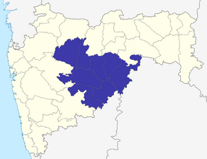
| Location of Aurangabad division in Maharashtra | |
| Districts | 1. Aurangabad, 2. Beed, 3. Hingoli, 4. Jalna, 5. Latur, 6. Nanded, 7. Osmanabad, 8. Parbhani |
| Area | 64,811 km2 (25,024 sq mi) |
| Population | 15,589,223 |
The Aurangabad Division is an important part of Maharashtra state in India. Think of it like a big region that helps organize how the state is run. It's one of six such main areas in Maharashtra. This division is named after its main city, Aurangabad.
Before 1956, this area was part of a larger kingdom called the Hyderabad State. This means its history is quite rich and interesting!
Contents
What is Aurangabad Division?
The Aurangabad Division is a large administrative area in the state of Maharashtra, India. An "administrative division" is like a big section of a state. It helps the government manage different areas more easily. Each division has several smaller areas called districts.
Location and Size
Aurangabad Division is located in the central part of Maharashtra. It covers a large area of about 64,811 square kilometers. That's a lot of land! Many people live here, with a population of over 15 million.
A Look at History
For a long time, before 1956, the land that is now Aurangabad Division was part of the Hyderabad State. This was a very important and powerful kingdom in India's history. After India became independent, these states were reorganized. That's when Aurangabad became a division within the new state of Maharashtra.
Districts of Aurangabad Division
The Aurangabad Division is made up of eight different districts. Each district has its own unique features and towns. These districts are:
Each of these districts plays a part in the overall life and economy of the Aurangabad Division.
See also
 In Spanish: División de Aurangabad para niños


