Bayraklı facts for kids
Quick facts for kids
Bayraklı
|
|
|---|---|
|
Settlement
|
|
 |
|

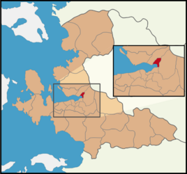
Map showing Bayraklı District in İzmir Province
|
|
| Country | Turkey |
| Province | İzmir |
| Area | 30 km2 (10 sq mi) |
| Elevation | 86 m (282 ft) |
| Population
(2022)
|
298,519 |
| • Density | 10,000/km2 (26,000/sq mi) |
| Time zone | TRT (UTC+3) |
| Area code | 0232 |
Bayraklı is a special part of İzmir Province in Turkey. It's like a big neighborhood or a smaller city within the larger city of İzmir. Bayraklı is a municipality and a district. This means it has its own local government that helps manage things for the people living there.
Bayraklı covers the northern part of İzmir's main city area. It's about 30 square kilometers in size. In 2022, nearly 300,000 people lived there. Bayraklı became its own district in 2008. Before that, it was part of another district called Karşıyaka.
Contents
What is Bayraklı?
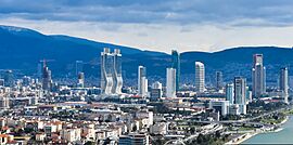
Bayraklı is a busy and important area in İzmir. It's known for its modern buildings and lively city life. Many people live and work here. It's a place where city planning helps everyone.
Where is Bayraklı Located?
Bayraklı is in the western part of Turkey. It sits right on the coast of the Aegean Sea. This makes it a great place with nice views. The district is part of the larger İzmir metropolitan area.
How Big is Bayraklı?
Bayraklı is not huge in size, but it has a lot of people. Its area is 30 square kilometers. Imagine a square about 5.5 kilometers on each side. That's roughly the size of Bayraklı.
Bayraklı's Population
In 2022, the population of Bayraklı was 298,519 people. This means it's a very populated area. Many families and young people call Bayraklı home.
History of Bayraklı
Bayraklı is a relatively new district. It was officially created in 2008. This happened to help manage the growing city of İzmir better. By splitting off from Karşıyaka, Bayraklı could focus on its own needs.
Why Was Bayraklı Created?
As İzmir grew, it became too big for just a few districts to manage. Creating new districts like Bayraklı helped local governments serve people more closely. It also allowed for better planning and development in this specific area.
Neighborhoods of Bayraklı
Bayraklı is made up of 24 different neighborhoods. Each neighborhood has its own unique feel. These smaller areas help people feel connected to their local community.
- 75. Yıl
- Adalet
- Alparslan
- Bayraklı
- Çay
- Cengizhan
- Çiçek
- Doğançay
- Emek
- Fuat Edip Baksi
- Gümüşpala
- Körfez
- Manavkuyu
- Mansuroğlu
- Muhittin Erener
- Onur
- Org. Nafiz Gürman
- Osman Gazi
- Postacılar
- Refik Şevket Ince
- Soğukkuyu
- Tepekule
- Turan
- Yamanlar
 | Roy Wilkins |
 | John Lewis |
 | Linda Carol Brown |


