
Botanical Provinces of Western Australia facts for kids
The botanical provinces of Western Australia, also known as Beard's Provinces, are special areas in Western Australia. They are defined by their climate and the types of plants that grow there. Think of them as natural plant zones! These zones help scientists understand where different plants live and why.
The idea of dividing Western Australia into plant regions started a long time ago. In 1906, a scientist named Ludwig Diels first split the state into two main areas: the Eremaean Province and the South-West Province. He looked at how much rain each area got, what kind of plants grew there, and where specific plant species were found.
Later, in 1944, another scientist named Charles Austin Gardner updated Diels' map. He added a new area called the Northern Province, which included the Kimberley and Pilbara regions. Then, in 1956, Gardner worked with Harold William Bennetts to make these divisions even more detailed for the whole state.
The maps we use today are based on the work of John Stanley Beard and other scientists. These maps help us describe where plants are found. For example, if you look up a plant like Parsonsia diaphanophleba in a plant database called Florabase, it might tell you it grows in Beard's South-West Province.
What are Beard's Provinces?
John Stanley Beard's work led to four main botanical provinces in Western Australia:
- Northern Province: This area includes regions like North Kimberley, Central Kimberley, East Kimberley, and Dampierland. It's known for its tropical climate.
- Eremaean Province: This is a very large area, mostly made up of deserts and dry lands. It includes places like the Great Sandy Desert, Gibson Desert, and the Nullarbor Region.
- South-Western Zone: This is a general term for the southern part of the state.
- South-West Province: This area is known for its unique plants and includes regions like the Northern Sandplains, Wheat Belt, and Esperance Plains. It has a Mediterranean-like climate.
These provinces help us understand the amazing variety of plant life across Western Australia.
Modern Plant Regions
Many of the smaller areas within Beard's provinces have been further refined. Today, scientists often use something called IBRA regions (Interim Biogeographic Regionalisation for Australia) to describe these plant zones in even more detail. These regions help with conservation efforts and understanding Australia's unique environment.
Images for kids
-
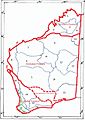
Map of the natural regions of Western Australia according to John Stanley Beard

