Bradford–Union Street Historic District facts for kids
Quick facts for kids |
|
|
Bradford–Union Street Historic District
|
|

Bradford Street
|
|
| Location | Plymouth, Massachusetts |
|---|---|
| Area | 7 acres (2.8 ha) |
| Architectural style | Greek Revival, Gothic Revival |
| NRHP reference No. | 83004094 |
| Added to NRHP | November 10, 1983 |
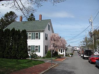
The Bradford–Union Street Historic District is a special part of Plymouth, Massachusetts. It's a neighborhood by the water that grew in the mid-1800s. Many people who worked in shipping and other local jobs lived here. This area is found where Bradford and Union Streets meet, right across from downtown Plymouth. In 1983, it was added to the National Register of Historic Places. This means it's recognized as an important historical area.
What is a Historic District?
A historic district is a group of buildings, structures, or objects that have been recognized for their historical or architectural importance. These areas are protected to help keep their unique character and history alive. They often show how people lived and worked in the past.
Plymouth's Early Days: A Maritime Story
Plymouth was first settled way back in 1620. Over time, it became a busy center for shipping and sea-related activities. In the 1800s, as more ships came and went, the town grew even bigger. More services were needed to support the busy port.
In 1812, a man named Samuel Doten built the first wharf (a kind of dock) in the area. Today, a yacht club stands where his wharf once was. Homes were built along the roads facing the water. They also went up the hill nearby. Union Street runs along the shore, giving access to the waterfront homes. Bradford Street and Water Street connect Union Street to Sandwich Street, which was a main road for many years.
Homes and History in the District
The Bradford Street area was developed in the 1840s. A person named Alden Harlow played a big part in building many homes here. He built many simple, one-and-a-half-story cottages. These homes often had three windows across the front. They are the most common type of house you'll see in the district today. These houses give the area its unique look and feel.
The historic district is centered around the meeting point of Bradford and Union Streets. It stretches a short distance along Union Street to the southeast. It also goes northwest to where Water Street joins in. The district includes all of Bradford Street. It also has houses on nearby Emerald, Freedom, and Watercure Streets.
The district covers about 7 acres (2.8 hectares). Today, it's mostly a neighborhood with homes. The old industries that helped it grow are mostly gone or have changed a lot. One of the last remaining signs of the old industries is the brick building of the Plymouth Marine Company. You can see it at Union and Water Streets.


