Burnside, Christchurch facts for kids
Quick facts for kids Burnside |
|
|---|---|

Burnside Park
|
|
| Basic information | |
| Local authority | Christchurch |
| Electoral ward |
|
| Land area | 457 ha (1.76 sq mi)* |
| Coordinates | 43°29′59″S 172°34′07″E / 43.499857°S 172.568658°E |
| Population | 9420 (June 2023) |
|
|
||
Burnside is a suburb in Christchurch, New Zealand. It is located southeast of the Christchurch International Airport. Like many areas in Christchurch, Burnside does not have exact borders. It is a general area within the city.
Contents
What is the history of Burnside?
Burnside was once a large farm. This farm was about 1,700 acres (6.9 square kilometers) in size. It belonged to an early settler named William Boag, who arrived in New Zealand in 1851.
The area was named "Burnside" because of the small creeks, or "burns," that flowed through it. These creeks were the start of the Waimairi Stream. The name Burnside became official in 1959. Before that, in 1950, Burnside Road was renamed Memorial Avenue. For about 100 years, the land in Burnside was used for farming. People raised sheep and cattle, and there were also fruit orchards.
Who lives in Burnside?
The Burnside area includes three smaller statistical areas: Burnside, Burnside Park, and Russley. Together, these areas cover about 4.57 square kilometers. As of 2023, the estimated population is around 7,600 people. This means there are about 1,660 people living in each square kilometer.
How has the population changed over time?
The number of people living in Burnside has grown steadily.
- In 2006, there were 7,191 people.
- In 2013, the population increased to 7,335.
- By 2018, it reached 7,713 people.
This shows an increase of about 5.2% between 2013 and 2018.
What are the people like in Burnside?
In 2018, there were 2,712 households in Burnside. There were slightly more females than males. About 18.9% of the people were under 15 years old. Around 21.8% were aged 15 to 29.
Many different groups of people live in Burnside.
- About 70.2% identified as European or Pākehā.
- Around 7.2% identified as Māori.
- About 2.9% were Pasifika.
- A larger group, 24.6%, identified as Asian.
- About 3.1% identified with other ethnic groups.
It's important to know that people can identify with more than one ethnicity.
About 32.6% of the people in Burnside were born outside of New Zealand. This is higher than the national average of 27.1%.
When it comes to religious beliefs, many people in Burnside do not have a specific religion (47.9%). Others follow different faiths:
- 39.1% were Christian.
- 1.4% were Hindu.
- 1.6% were Muslim.
- 2.0% were Buddhist.
- Other religions made up 2.1%.
What schools are in Burnside?
Burnside has several schools for different age groups.
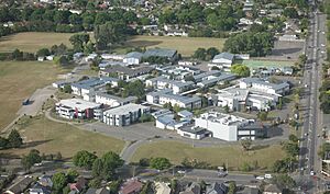
- Burnside High School is a secondary school. It teaches students from Year 9 to Year 13. The school opened in 1960. It has a roll of 2,439 students.
- Cobham Intermediate is an intermediate school. It is for students in Years 7 and 8. This school opened in 1963 and was first called Fendalton Intermediate. It has a roll of 631 students.
- Burnside Primary School and Roydvale School are primary schools. They teach students from Year 1 to Year 6. Burnside School opened in 1956 and has a roll of 298 students. Roydvale School opened in 1967 and has a roll of 269 students.
- Christ the King School is a state-integrated Catholic primary school. It teaches students from Year 1 to Year 8. It has a roll of 308 students.
All these schools teach both boys and girls. All of them, except Christ the King School, are state schools. The student numbers are from February 2024. .
What is Burnside like?
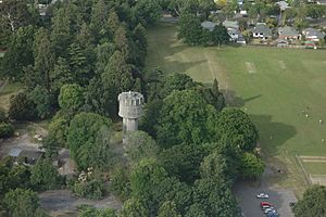
Burnside has a large central green space called Burnside Park. The two main roads in the area are Memorial Avenue and Greers Road. There is also a smaller park called Jellie Park, which is located across from Burnside High School on Greers Road.
 | Laphonza Butler |
 | Daisy Bates |
 | Elizabeth Piper Ensley |


