
Burrow Island facts for kids

Burrow Island is a small piece of land in Gosport, United Kingdom. It is also known as 'Rat Island'. This island is special because it is a tidal island. This means you can sometimes walk to it from the mainland when the tide is low.
Burrow Island is located near Portsmouth Harbour. When the tide goes out, a narrow strip of land connects it to an area called Priddy's Hard. People think the name "Burrow Island" might come from the 17th century. It could be named this because it was part of the Gosport area, which is a borough.
History of Fort James
In the late 1600s, a small fort was built on Burrow Island. This happened between 1678 and 1679. The fort was called Fort James. It was built under the guidance of a person named Bernard de Gomme. The fort was a square tower, about 19 feet (5.8 meters) tall.
Over time, the fort was not kept in good condition. By the early 1700s, it was already falling apart. There were plans in 1750 to rebuild it with a new design, but this never happened. The old ruins of the fort were partly taken down in 1827. Today, you cannot see any parts of the fort above the ground.
Some stories say that King Stephen built a fort on the island a very long time ago. However, historians believe this is probably not true.
Island Access and Discoveries
Burrow Island is currently owned by the Ministry of Defence. This means it is used by the military. Because of this, the public is generally not allowed to visit the island.
Even though access is restricted, some people do go onto Burrow Island when the tide is low. It is a popular spot for fishing. People have also found interesting old glass bottles washed up on the shore. These bottles often have unique colours.
In 2014, something unusual was found on the island. Several human skeletons were discovered. Experts believe these bones are from the 1800s. They are thought to be the remains of prisoners or soldiers from that time who were buried on the island.
Burrow Island is one of 43 tidal islands in Great Britain that you can walk to from the mainland. These islands do not have bridges connecting them.
Images for kids
-
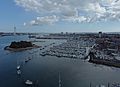
Burrow Island and the nearby marina.

See also
 In Spanish: Isla Burrow para niños
