
California Historical Landmarks in Marin County facts for kids
A California Historical Landmark is a special place or building that has been officially recognized for its important history in California. These landmarks help us remember and learn about the past. Marin County, located just north of San Francisco, has many of these cool historical spots! Let's explore some of them.
Exploring Marin County's History
Marin County is full of interesting places that tell stories from long ago. From islands to bridges, these landmarks show how California grew and changed over time.
Angel Island: The "Ellis Island of the West"

Angel Island is a large island in San Francisco Bay. It has a rich history, serving many roles over the years. It was once a military post, a quarantine station for people arriving by ship, and most famously, an immigration station. From 1910 to 1940, many immigrants from Asia came through Angel Island, similar to how Ellis Island worked on the East Coast. Today, it's a beautiful state park where you can hike and learn about its past.
China Camp: A Historic Fishing Village

China Camp State Park is home to a historic Chinese fishing village. This village shows how Chinese immigrants lived and worked in California during the late 1800s. They fished for shrimp and other seafood, playing a big part in the local economy. It's a great place to learn about the challenges and contributions of early Chinese settlers.
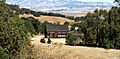
First Sawmill in Marin County

In Mill Valley, you can find the site of the first sawmill in Marin County. This mill was very important for building homes and towns in the early days of California. It helped provide the wood needed for new settlements as more people moved to the area. The site is now part of Old Mill Park, a peaceful place to visit.
Golden Gate Bridge: An Iconic Landmark

The Golden Gate Bridge is one of the most famous bridges in the world. It connects Marin County to San Francisco and is known for its stunning design and bright orange-red color. When it opened in 1937, it was an amazing engineering feat. It's not just a bridge; it's a symbol of California and a vital link for travel.
Marin County Civic Center: A Unique Building

The Marin County Civic Center is a very special building designed by the famous architect Frank Lloyd Wright. It's known for its unique blue roofs and long, flowing lines that blend with the landscape. It serves as the main government building for Marin County. Its design is so important that it's also listed on the National Register of Historic Places.
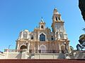
Mission San Rafael Arcángel

Mission San Rafael Arcángel was one of the 21 Spanish missions built in California. It was founded in 1817 and was originally a hospital asistencia (branch) of Mission San Francisco de Asís. It became a full mission later. These missions played a big role in the early history of California, often serving as centers for farming and religious life.
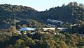
Olompali State Historic Park
.JPG)
Olompali State Historic Park is a place with a very long history. It was once a Native American village, home to the Coast Miwok people for thousands of years. Later, it became a Mexican land grant and then a ranch. The park helps us understand the different cultures and people who have lived in this area over time.
St. Vincent's School for Boys

St. Vincent's School for Boys is a historic institution in San Rafael. It was founded in 1855 to help educate and care for boys in need. For many years, it provided a home and schooling for thousands of young people. It continues to serve the community today, helping children and families.
Images for kids
-
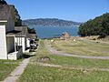
A view of Camp Reynolds on Angel Island.
-
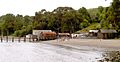
Boats docked at China Camp State Park.
-
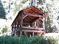
Old Mill Park in Mill Valley.
-
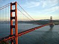
The famous Golden Gate Bridge connecting Marin County to San Francisco.
-
The Marin County Civic Center, designed by Frank Lloyd Wright.
-

Mission San Rafael Arcángel in San Rafael.
-
The historic Burdell Barn at Olompali State Historic Park.
-
St. Vincent's School for Boys in San Rafael.
