Chachagüí facts for kids
Quick facts for kids
Chachagüí
|
||
|---|---|---|
|
Municipality and town
|
||
|
||

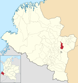
Location of the municipality and town of Chachagüí in the Nariño Department of Colombia.
|
||
| Country | ||
| Department | Nariño Department | |
| Area | ||
| • Total | 148 km2 (57 sq mi) | |
| Population
(Census 2018)
|
||
| • Total | 12,419 | |
| • Density | 83.91/km2 (217.3/sq mi) | |
| Time zone | UTC-5 (Colombia Standard Time) | |
Chachagüí is a town and a municipality in the Nariño Department of Colombia. It is a place where many people live and work. A municipality is like a local government area, similar to a county or district.
Where is Chachagüí?
Chachagüí is located in the southwestern part of Colombia. It is part of the Nariño Department. You can see its location on the map in the box at the top of this page. This area is known for its beautiful landscapes.
What is Chachagüí Like?
Chachagüí is home to about 12,419 people, based on the 2018 census. The town covers an area of about 148 square kilometers. That's roughly the size of 14,800 football fields! It's a place where people live, go to school, and have local businesses.
What's the Climate Like?
Chachagüí has a special kind of weather called a subtropical highland climate. This means it's usually warm and mild all year round. It's not too hot and not too cold.
- The average temperature is around 19 to 20 degrees Celsius (66 to 68 degrees Fahrenheit).
- Even though it's warm, Chachagüí gets a lot of rain for most of the year.
- The driest months are usually July and August.
- The wettest months are often April, October, and November.
- This steady climate makes it a pleasant place to live.
| Climate data for Chachagüí (Antonio Nariño Airport), elevation 1,816 m (5,958 ft), (1981–2010) | |||||||||||||
|---|---|---|---|---|---|---|---|---|---|---|---|---|---|
| Month | Jan | Feb | Mar | Apr | May | Jun | Jul | Aug | Sep | Oct | Nov | Dec | Year |
| Mean daily maximum °C (°F) | 22.9 (73.2) |
23.3 (73.9) |
23.4 (74.1) |
23.4 (74.1) |
23.7 (74.7) |
24.3 (75.7) |
24.9 (76.8) |
25.6 (78.1) |
25.3 (77.5) |
23.6 (74.5) |
22.5 (72.5) |
22.4 (72.3) |
23.8 (74.8) |
| Daily mean °C (°F) | 18.7 (65.7) |
19.0 (66.2) |
19.1 (66.4) |
19.1 (66.4) |
19.3 (66.7) |
19.6 (67.3) |
19.8 (67.6) |
20.2 (68.4) |
19.8 (67.6) |
18.9 (66.0) |
18.4 (65.1) |
18.4 (65.1) |
19.2 (66.6) |
| Mean daily minimum °C (°F) | 14.6 (58.3) |
14.8 (58.6) |
15.0 (59.0) |
15.1 (59.2) |
15.2 (59.4) |
14.8 (58.6) |
14.5 (58.1) |
14.7 (58.5) |
14.5 (58.1) |
14.6 (58.3) |
14.7 (58.5) |
14.8 (58.6) |
14.8 (58.6) |
| Average precipitation mm (inches) | 99.4 (3.91) |
89.9 (3.54) |
128.0 (5.04) |
153.9 (6.06) |
122.1 (4.81) |
53.9 (2.12) |
33.7 (1.33) |
20.1 (0.79) |
63.4 (2.50) |
146.9 (5.78) |
161.4 (6.35) |
127.7 (5.03) |
1,200.4 (47.26) |
| Average precipitation days | 15 | 14 | 18 | 19 | 18 | 12 | 8 | 8 | 11 | 18 | 20 | 18 | 178 |
| Average relative humidity (%) | 81 | 80 | 80 | 82 | 81 | 74 | 66 | 63 | 69 | 80 | 84 | 84 | 77 |
| Mean monthly sunshine hours | 167.4 | 141.2 | 139.5 | 141.0 | 161.2 | 183.0 | 207.7 | 207.7 | 171.0 | 161.2 | 153.0 | 161.2 | 1,995.1 |
| Mean daily sunshine hours | 5.4 | 5.0 | 4.5 | 4.7 | 5.2 | 6.1 | 6.7 | 6.7 | 5.7 | 5.2 | 5.1 | 5.2 | 5.5 |
| Source: Instituto de Hidrologia Meteorologia y Estudios Ambientales | |||||||||||||
See also

- In Spanish: Chachagüí para niños
 | Sharif Bey |
 | Hale Woodruff |
 | Richmond Barthé |
 | Purvis Young |


