
City of San Luis Obispo Historic Resources facts for kids
The City of San Luis Obispo Historic Resources are special buildings and places in San Luis Obispo, California that the city has officially recognized as important parts of its history.
You can see where these historic places are on a map! Just click "OpenStreetMap" in the box to the right.
Contents
Why are these places special?
The city has a group called the Cultural Heritage Committee (CHC). This committee has seven members who are chosen by the City Council. Their main job is to find, study, and protect old buildings, ancient sites, and important cultural spots.
To be called "historic," a place must be at least 50 years old and still look mostly like it did in the past. It also needs to be special for reasons like:
- Being designed by a famous architect.
- Having a unique architectural style.
- Being connected to an important person or event in history.
In 2013, the city created a "Citywide Historic Context Statement." This document helps people understand how these historic places fit into the bigger story of San Luis Obispo's past. It explains the link between the city's buildings and its history. You can find this statement and other guidelines on the city's website.
Other important lists
Some of San Luis Obispo's historic places are so important that they are also recognized by the state or even the whole country!
Three of these places are also California Historic Landmarks:
- Mission San Luis Obispo de Tolosa (CHL 325)
- Dallidet Adobe (CHL 720)
- Ah Louis Store (CHL 802)
Eight places are listed on the National Register of Historic Places (NRHP), which is a national list of important historic sites:
- Myron Angel House (listed in 1982)
- Pacific Coast Railway Company Grain Warehouse (listed in 1988)
- Robert Jack House (listed in 1992)
- Tribune-Republic Building (listed in 1993)
- San Luis Obispo Carnegie Library (listed in 1995)
- Ah Louis Store (listed in 2008)
- William Shipsey House (listed in 2010)
- Monday Club of San Luis Obispo (listed in 2016)
There are also two other places in San Luis Obispo that are on the National Register of Historic Places but are not on the city's list. These are The Powerhouse on the CalPoly campus and the San Luis Obispo Octagon Barn.
Historic Places in San Luis Obispo
Here are some of the interesting historic places in San Luis Obispo:
| # | Name | Image | Location | Historic District |
Built | Description |
|---|---|---|---|---|---|---|
| 1 | Andrews Adobe | 1451 Andrews | 1790s | A two-story adobe house, one of the oldest buildings in the county. | ||
| 16 | Myron Angel House |  |
714 Buchon | Old Town HD | c. 1880 | Home of Myron Angel, who helped start Cal Poly. Listed on the NRHP in 1982. |
| 17 | Jessie Wright Maternity Home | 726 Buchon | Old Town HD | 1900 | A wood-frame home that was a maternity hospital in the 1920s. | |
| 22 | Jacob Crocker House | 793 Buchon | Old Town HD | 1901-02 | An ornate Queen Anne style house built for a wealthy businessman. | |
| 24 | Clark/Norton House | 850 Buchon | Old Town HD | 1904-08 | A large Neo-Colonial house, once home to two SLO mayors. | |
| 32 | Sauer/Adams Adobe | 964 Chorro | Chinatown HD | 1800/1860 | An original adobe building from around 1800, with a second story added later. | |
| 40 | Barneberg House | 550 Dana | Downtown HD | 1914 | A two-story Neo-Classical house built for a bank president and millionaire. | |
| 58 | Goldtree Block/Hotel Wineman |  |
849 Higuera | Downtown HD | 1883/1930 | A large commercial building that was once a general store and later a hotel. |
| 62 | Loomis Feed Co. Warehouse |  |
75 Higuera | 1885 | The only remaining building from the Pacific Coast Railway's headquarters. Listed on the NRHP in 1988. | |
| 77 | Madonna Inn |  |
100 Madonna | 1961-69 | A famous motel known for its unique, themed rooms and pink roses. | |
| 88 | Robert Jack House |  |
536 Marsh | 1880 | An Italianate-style house that is now a city museum and event center. Listed on the NRHP in 1992. | |
| 91 | First Presbyterian Church | 951 Marsh | 1905 | An English Arts and Crafts style church built with local granite. | ||
| 93 | William Shipsey House |  |
1266 Mill | Mill Street HD | 1890 | A house with Queen Anne and Stick/Eastlake styles. Listed on NRHP in 2010. |
| 99 | Mission San Luis |  |
782 Monterey | Downtown HD | 1812 | A Spanish mission founded in 1772 by Father Junípero Serra. |
| 100 | Fremont Theater |  |
1035 Monterey | Downtown HD | 1941 | A Streamline Moderne style theater designed by architect S. Charles Lee. |
| 102 | San Luis Obispo Carnegie Library | .jpg) |
696 Monterey | Downtown HD | 1905 | A beautiful red brick library, now the county's historical museum. Listed on NRHP in 1995. |
| 105 | Sinsheimer Building | 849 Monterey | Downtown HD | 1884 | A commercial building with a rare cast iron facade on the Central Coast. | |
| 107 | Anderson Hotel | 955 Monterey | Downtown HD | 1922-23 | An elegant five-story hotel, once the tallest building downtown. | |
| 110 | Monday Club |  |
1815 Monterey | 1933 | A building designed by the famous architect Julia Morgan. Listed on the NRHP. | |
| 111 | Milestone Motel Inn | .jpg) |
2223 Monterey | 1924-25 | This place is said to be the first motel in the world! | |
| 118 | St. Stephen's Episcopal Church |  |
1344 Nipomo | Old Town HD | 1873 | A historic church in the Old Town district. |
| 125 | County Courthouse | 976 Osos | Downtown HD | 1941 | An Art Deco building that was the county courthouse, now a planning office. | |
| 129 | Kundert Medical Building | 1106 Pacific | 1956 | One of the last designs by the famous architect Frank Lloyd Wright. | ||
| 130 | Dallidet Adobe |  |
1185 Pacific | 1856 | An adobe building managed by the county historical society. It's a California Historical Landmark. | |
| 132 | Ah Louis Store | .jpg) |
800 Palm | Chinatown HD | 1884 | A commercial building built by Chinese businessman Ah Louis using bricks from his own brickyard. Listed on NRHP in 2008. |
| 145 | Southern Pacific Depot |  |
1011 Railroad | Railroad HD | 1943 | A railroad station listed on the NRHP in 1993. |
| 146 | Tribune-Republic Building | 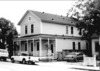 |
1763 Santa Barbara | Railroad HD | 1873 | The oldest wooden commercial building in SLO, once home to several newspapers. |
| 149 | Southern Pacific Warehouse |  |
1940 Santa Barbara | Railroad HD | 1900 | A warehouse from the Southern Pacific Railroad era. |
| 151 | Adriance Court | 1531 Santa Rosa | Old Town HD | 1921 | Housing built for railroad workers. | |
| 155 | Southern Pacific Water Tower |  |
1100 Iris | 1940 | An old water tower used by the Southern Pacific Railroad. | |
| 158 | La Loma De La Nopalera Adobe | 1590 Lizzie | 1780 | A very old adobe building. | ||
| 161 | SLO High School Gymnasium | 1499 San Luis | 1936 | The gymnasium at San Luis Obispo High School. | ||
| 170 | Southern Pacific Roundhouse | 1335 Roundhouse | Railroad HD | 1901-13 | A building used for turning and repairing train engines. |
Historic Neighborhoods (Districts)
San Luis Obispo also has special historic districts, which are areas with many historic buildings that share a common past.
| Name | Image | Boundaries | Description |
| Downtown Historic District | Around Palm, Marsh, Osos, and Nipomo Streets, plus Dana Street | This area includes the oldest parts of SLO, like the Mission, and many commercial buildings from the city's busy years between the 1890s and 1910s. | |
| Old Town Historic District | Around Pacific, Islay, Santa Rosa, and Beach Streets | Created in 1987, this district has many old homes from the 1880s and early 1900s in SLO's first neighborhoods. | |
| Chinatown Historic District | Both sides of Palm Street between Chorro and Morro Streets | Established in 1995, this district honors the important contributions of SLO's Chinese community. | |
| Mill Street Historic District | Around Peach, Palm, Pepper, and Toro Streets | Also created in 1987, this district features tree-lined streets with early 20th-century homes in various styles like Tudor Revival and Craftsman. | |
| Railroad Historic District | Near the railroad tracks, Johnson Avenue, Orcutt Road, Leff Street, and Broad Street | This district was created in 1998 and includes homes and businesses built after the Southern Pacific Railroad arrived in 1894. |
See also
