
Coast Watching Service facts for kids
The Irish Defence Forces created a special group called the Coast Watching Service during World War II. In Ireland, this time was known as The Emergency because the country chose to remain neutral (not picking a side).
Between 1939 and 1942, they built 83 special buildings called Lookout Posts, or LOPs. These were placed in important spots along the Irish coast, usually every 5 to 15 miles. Local volunteers, known as Coastwatchers, worked at these posts. Their job was to watch the sea and sky near their post for any signs of activity from countries involved in the war.
After the war ended, most of these buildings were left empty. Some were even taken down. But many still exist today, and some are in good condition. The ones in more remote places are usually the best preserved.
Contents
Who Were the Coastwatchers?
Coastwatchers were volunteers who worked all day and night. They worked in pairs, taking turns on eight- or twelve-hour shifts. One person would stay inside the LOP, operating the telephone. The other would patrol outside, keeping a close eye on the surroundings.
Their main job was to report everything they saw. This included any ships or planes in their area. Each Lookout Post had its own special number. LOP 1 was in County Louth, and the numbers went up as you moved clockwise around the coast. The last one, LOP 82, was in County Donegal. There was also an LOP 83, located in County Kerry.
Keeping Records: The Logbooks
Every Lookout Post had to keep detailed records of what they observed. These records were written in special books called logbooks. Many of these logbooks have survived over the years. They are now kept safe at the Irish Military Archives. These books give us a glimpse into what the Coastwatchers saw and reported during the war.
The "EIRE" Signs on the Coast

After the Lookout Posts were built, a decision was made to add large signs along the coast. These signs spelled out the word "EIRE" (the Irish name for Ireland). The idea was to help pilots who might have lost their way. If they saw "EIRE," they would know they were over neutral Ireland. This would hopefully stop them from landing by mistake.
According to a book called Guarding Neutral Ireland by Michael Kennedy, these signs were put up because the American authorities asked for them. Some of the first signs, like the one at Cahore Point in County Wexford, were too small. So, bigger signs were built over them later on. Many of these "EIRE" signs can still be seen today, especially along the west coast. Some have even been restored, like the one at Loop Head in County Clare.
Images for kids
-
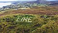
An "EIRE" sign at Glengad Head, Ireland.
See also
