Corozal, Sucre facts for kids
Quick facts for kids
Corozal, Sucre
|
|||
|---|---|---|---|
|
Municipality and town
|
|||
 |
|||
|
|||

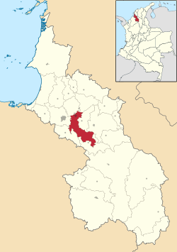
Location of the municipality and town of Corozal, Sucre in the Sucre Department..
|
|||
| Country | |||
| Department | Sucre Department | ||
| Area | |||
| • Municipality and town | 285.9 km2 (110.4 sq mi) | ||
| • Urban | 4.81 km2 (1.86 sq mi) | ||
| Elevation | 142 m (466 ft) | ||
| Population
(2023 census)
|
|||
| • Municipality and town | 70,591 | ||
| • Density | 246.91/km2 (639.49/sq mi) | ||
| • Urban | 52,855 | ||
| • Urban density | 10,989/km2 (28,460/sq mi) | ||
| Demonym(s) | Corozalero | ||
| Time zone | UTC-5 (Colombia Time) | ||
| Area code(s) | 57 + 5 | ||
| Website | Official website: http://www.corozal-sucre.gov.co/ | ||
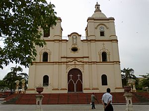
Corozal (pronounced ko-ro-SAL) is a town and a special area called a municipality in northern Colombia. It is located in the Sucre Department. Corozal is an important place for the people living in this part of Colombia.
Contents
Getting Around Corozal
How to Travel to Corozal
Corozal has its own airport, which makes it easy to visit. The airport is called Las Brujas Airport. This airport helps people travel to and from the town.
Famous People from Corozal
Meet a Notable Corozalero
Many interesting people come from Corozal. One famous person is José Serpa. He was born in 1979 and is a professional cyclist. He has competed in many races around the world.
Understanding Corozal's Climate
Weather Patterns in Corozal
Corozal has a warm climate all year round. It is located in a tropical area. This means it usually has high temperatures. The town also experiences a rainy season and a dry season.
| Climate data for Corozal (Las Brujas Airport), elevation 166 m (545 ft), (1981–2010) | |||||||||||||
|---|---|---|---|---|---|---|---|---|---|---|---|---|---|
| Month | Jan | Feb | Mar | Apr | May | Jun | Jul | Aug | Sep | Oct | Nov | Dec | Year |
| Mean daily maximum °C (°F) | 33.7 (92.7) |
34.1 (93.4) |
34.3 (93.7) |
33.5 (92.3) |
32.1 (89.8) |
31.4 (88.5) |
32.2 (90.0) |
32.2 (90.0) |
31.4 (88.5) |
31.1 (88.0) |
31.5 (88.7) |
32.6 (90.7) |
32.5 (90.5) |
| Daily mean °C (°F) | 27.8 (82.0) |
28 (82) |
28.3 (82.9) |
28.2 (82.8) |
27.7 (81.9) |
27.5 (81.5) |
27.6 (81.7) |
27.6 (81.7) |
27 (81) |
26.8 (80.2) |
27 (81) |
27.4 (81.3) |
27.5 (81.5) |
| Mean daily minimum °C (°F) | 22 (72) |
22.6 (72.7) |
23.2 (73.8) |
23.6 (74.5) |
23.2 (73.8) |
22.9 (73.2) |
22.7 (72.9) |
22.6 (72.7) |
22.5 (72.5) |
22.6 (72.7) |
22.5 (72.5) |
22.1 (71.8) |
22.7 (72.9) |
| Average precipitation mm (inches) | 18.1 (0.71) |
19.6 (0.77) |
35.3 (1.39) |
91.6 (3.61) |
150.1 (5.91) |
137.1 (5.40) |
138.7 (5.46) |
140.5 (5.53) |
139 (5.5) |
135 (5.3) |
85.9 (3.38) |
36.9 (1.45) |
1,127.9 (44.41) |
| Average precipitation days (≥ 1.0 mm) | 2 | 3 | 3 | 9 | 14 | 12 | 11 | 13 | 13 | 13 | 9 | 4 | 105 |
| Average relative humidity (%) | 76 | 76 | 76 | 78 | 82 | 83 | 82 | 82 | 84 | 84 | 83 | 80 | 80 |
| Mean monthly sunshine hours | 235.6 | 203.3 | 186 | 144 | 142.6 | 168 | 189.1 | 176.7 | 135 | 148.8 | 153 | 204.6 | 2,086.7 |
| Mean daily sunshine hours | 7.6 | 7.2 | 6 | 4.8 | 4.6 | 5.6 | 6.1 | 5.7 | 4.5 | 4.8 | 5.1 | 6.6 | 5.7 |
| Source: Instituto de Hidrologia Meteorologia y Estudios Ambientales | |||||||||||||
More About Corozal
Explore Other Resources
 If you want to learn even more about Corozal, you can check out this page in Spanish: Corozal (Colombia) para niños
 | Selma Burke |
 | Pauline Powell Burns |
 | Frederick J. Brown |
 | Robert Blackburn |


