
Course of San Juan Creek facts for kids

San Juan Creek is a natural waterway, or creek, located in Orange County, California. It stretches for about 29 miles (47 km) and, together with its main branch, Trabuco Creek, helps drain a large area of 133 square miles (344 km²) in southern Orange County. This article will take you on a journey along San Juan Creek, from where it begins high in the mountains to where it meets the ocean.
Contents
Where the Creek Begins: Headwaters to San Juan Canyon
San Juan Creek starts its journey high up in the southern Santa Ana Mountains, not far from Lake Elsinore. It begins at a very high point, about 5,100 feet (1,554 meters) above sea level!
In its highest parts, the creek often flows in different directions – south, west, and sometimes northwest. It runs alongside the Ortega Highway. Here, the creek is often ephemeral, meaning it only flows when there's enough rain, and can dry up at other times.
A Mountain Stream with Waterfalls
The very first part of the creek is a narrow mountain stream. It has many fast-moving sections called rapids and beautiful waterfalls. One famous spot is San Juan Falls, which is a series of cascades, or small waterfalls, that are about 5 to 15 feet (1.5 to 4.6 meters) tall.
The creek here flows mostly over solid rock, with not much sand or gravel on its bed. You can see a "pool-and-riffle" pattern, where the water flows fast over shallow, rocky areas (riffles) and then slows down into deeper, calmer pools.
Most of this canyon is too narrow for buildings. The main thing that affects the creek in San Juan Canyon is the Ortega Highway, which follows the creek's path.

As the creek leaves its starting point, it winds its way south and west, then mostly west-southwest. It gets water from smaller streams like Long Canyon, Morell Canyon, and Bear Canyon.
The creek then plunges over San Juan Falls, a 15-foot (4.6-meter) drop, followed by more smaller falls. In this area, there are many stream pools that can become still and quiet when the water flow is low. As the valley slowly gets wider, San Juan Creek continues west, dropping over more falls before it finally widens to about 330 feet (100 meters).
The Widening Valley and More Tributaries
About 1 mile (1.6 km) below the main falls, the valley starts to collect more sand and gravel. The creek spreads out, with short sections of fast-moving water between calm pools. After flowing through this wider valley for about 2 miles (3.2 km), the creek narrows again into a steep canyon. Here, it is joined by Lion Canyon.
The creek then goes under its first major bridge, a stone arch bridge that carries the Ortega Highway. After this bridge, Hot Springs Creek joins San Juan Creek. This creek is fed by the San Juan Hot Springs. Cold Springs Creek also joins about 2,000 feet (610 meters) downstream. About 1 mile (1.6 km) further, Lucas Canyon Creek adds its water to San Juan Creek.
From San Juan Canyon to San Juan Capistrano
After San Juan Creek leaves the narrow San Juan Canyon, it spreads out into a wider, braided channel. This means the water flows in many smaller paths over large areas of sand and gravel. The creek bed can be anywhere from 100 to 700 feet (30 to 213 meters) wide! During the dry season, the water often flows *underground* in this section.
In this middle part of the creek, the land is mostly used for farming and ranching. The creek winds in big curves, with many islands and areas of plants.
Meeting Other Creeks
Lucas Canyon Creek joins San Juan Creek at the beginning of this wider valley. A few miles later, Bell Canyon, the second largest branch, flows into San Juan Creek. At almost the same spot, Verdugo Canyon also joins the creek from the other side. Bell Canyon can carry pollution from nearby neighborhoods.
The creek then turns northwest and meets Trampas Canyon. Soon after, two more important branches, Cañada Gobernadora and Cañada Chiquita, join the creek. San Juan Creek then turns south again, flowing past an elementary school.
About 7.5 miles (12.1 km) downstream from Bell Canyon, and 11.3 miles (18.2 km) from San Juan Canyon, San Juan Creek enters the city of San Juan Capistrano. From this point on, the creek flows through a man-made channel for the rest of its journey.
Changes Along the Way
Even though San Juan Creek is not fully channelized between San Juan Canyon and the city, it does have some changes. The Ortega Highway crosses the creek twice in this section. At the first bridge, the creek channel is made narrower, from 500 feet (152 meters) down to 100 feet (30 meters).
Near where Bell Canyon joins, an access road crosses San Juan Creek. Here, the creek's water is sent through large pipes called culverts, which are 36 inches (91 cm) wide. There are also wire cages filled with rocks, called gabions, along parts of the creek. These are mainly found near stream crossings to help control the water flow.
There are also two places in the middle part of the creek where the water drops, but doesn't form a dam. One is a small gabion structure at the entrance of Caspers Wilderness Park. The other is a natural sandstone rock formation under a bridge.
Trabuco Creek to the Ocean Mouth

The last part of San Juan Creek begins after it flows under Interstate 5. After passing under the highway, the creek suddenly enters a special channel built to control floods. This channel has concrete walls and an earthen (dirt) bottom.
The creek flows southwest, slowly curving south. Very soon, El Horno Creek joins it underground. A short distance later, San Juan Creek meets its largest branch, Trabuco Creek.
The Mighty Trabuco Creek
Trabuco Creek starts in the northern part of the watershed and drains most of the northern half of the area. It flows mostly west, then south-southwest, through a valley that has more buildings and development than the main San Juan Creek valley. For much of its lower part, it flows alongside Interstate 5. About 4 miles (6.4 km) from its end, Trabuco Creek receives its own major branch, Oso Creek. Finally, Trabuco Creek flows into a south-flowing flood control channel that meets San Juan Creek inside San Juan Capistrano.
The Final Stretch to the Lagoon
After Trabuco Creek joins, San Juan Creek flows mostly south for about 2.7 miles (4.3 km). It only bends slightly to the southeast in this entire section. The channel is about 300 feet (91 meters) wide and 20 feet (6.1 meters) deep, with a bicycle path running along its west side.
The creek then crosses the border between San Juan Capistrano and the city of Dana Point. Here, its channel gets wider and shallower. It flows under a high bridge for Camino Las Ramblas, and then under two lower bridges for the Pacific Coast Highway.
Right after these last bridges, San Juan Creek flows into a freshwater lagoon. This lagoon is about 900 feet (274 meters) south of the north end of Doheny State Beach. A natural sand barrier blocks the water from reaching the ocean. When the lagoon is full, it forms a small lake that even goes under the highway. Sometimes, the sand barrier breaks open, causing a lot of water to rush into the ocean. Even when the sand blocks the surface water, some water from the creek can still flow through the sand and into the ocean, which means Doheny State Beach and Capistrano Bay can get pollution from the creek.
Images for kids
-
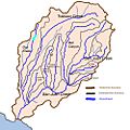
Map of San Juan Creek watershed
-
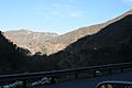
San Juan Canyon viewed from Ortega Highway
-
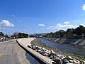
San Juan Creek flows through a flood control channel for its lower 2.7 miles (4.3 km).
