
Diana's Peak facts for kids
Quick facts for kids Diana's Peak |
|
|---|---|
| Highest point | |
| Elevation | 818 m (2,684 ft) |
| Geography | |
| Location | Saint Helena, South Atlantic Ocean |
Diana's Peak is the tallest point on the beautiful island of Saint Helena. This amazing peak reaches about 823 metres (2,700 ft) into the sky! It was formed long ago by a volcano.
In March 1996, Diana's Peak became Saint Helena's very first national park. This means it's a special protected area, home to many unique plants like tall tree ferns.
Where is Diana's Peak?
This peak is located right in the middle of Saint Helena. It's a special spot where three different areas, called districts, meet. These districts are Sandy Bay (to the southwest), Levelwood (to the east), and Longwood (to the north).
The closest small towns or villages to Diana's Peak are Bamboo Hedge (which is the main village in Sandy Bay District), Hutt's Gate (in Longwood District), and Levelwood Village.
Part of a Mountain Range
Diana's Peak is part of a small group of mountains called the Peaks Ridge. This is a narrow and short mountain range found in the very center of the island. Another important peak in this same range is called Mt. Actaeon.
Images for kids
-
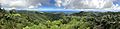
Panoramic view from Diana's Peak
See also
 In Spanish: Pico de Diana para niños
