Dolores, Colombia facts for kids
Quick facts for kids
Dolores, Tolima
|
|||
|---|---|---|---|
|
Municipality and town
|
|||
|
|||

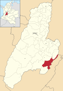
Location of the municipality and town of Dolores, Tolima in the Tolima Department of Colombia.
|
|||
| Country | Colombia | ||
| Department | Tolima Department | ||
| Area | |||
| • Total | 672 km2 (259 sq mi) | ||
| Elevation | 1,445 m (4,741 ft) | ||
| Population
(2017)
|
|||
| • Total | 7,923 | ||
| Time zone | UTC-5 (Colombia Standard Time) | ||
Dolores is a cool town and a special area called a municipality in the Tolima department of Colombia. It's a place where people live and work, surrounded by beautiful nature. In 2017, about 7,923 people lived there.
Contents
What is Dolores Like?
Dolores is located in the Tolima Department, which is a part of Colombia. It's a municipality, which means it's a local government area, kind of like a county or a borough, but it also includes the main town of Dolores. The total area of the municipality is about 672 square kilometers.
Who Leads Dolores?
Like any town, Dolores has a leader! The main leader is called the Mayor. From 2020 to 2023, the Mayor of Dolores was Cesar Giovanny. The Mayor helps make decisions for the town and its people.
How High Up is Dolores?
Dolores is located quite high up! Its elevation is about 1,445 meters (or 4,741 feet) above sea level. This high elevation often means the town has a pleasant climate, not too hot and not too cold.
What's the Weather Like in Dolores?
The climate in Dolores is generally warm and humid, but because it's high up, it's not usually extremely hot. You can expect temperatures to be pretty steady throughout the year, often around 21 degrees Celsius (about 70 degrees Fahrenheit).
It rains quite a bit in Dolores, especially during certain months like October and November. These rainy periods help keep the land green and support the local plant life. Even with the rain, there's still plenty of sunshine to enjoy!
| Climate data for Dolores (Dolores Hda Madron), elevation 1,456 m (4,777 ft), (1981–2010) | |||||||||||||
|---|---|---|---|---|---|---|---|---|---|---|---|---|---|
| Month | Jan | Feb | Mar | Apr | May | Jun | Jul | Aug | Sep | Oct | Nov | Dec | Year |
| Mean daily maximum °C (°F) | 24.6 (76.3) |
24.7 (76.5) |
24.8 (76.6) |
24.4 (75.9) |
24.4 (75.9) |
24.2 (75.6) |
24.3 (75.7) |
25.5 (77.9) |
25.7 (78.3) |
24.5 (76.1) |
23.7 (74.7) |
24.0 (75.2) |
24.6 (76.3) |
| Daily mean °C (°F) | 21.1 (70.0) |
21.3 (70.3) |
21.2 (70.2) |
21.1 (70.0) |
21.1 (70.0) |
20.9 (69.6) |
20.8 (69.4) |
21.5 (70.7) |
21.7 (71.1) |
21.1 (70.0) |
20.6 (69.1) |
20.8 (69.4) |
21.1 (70.0) |
| Mean daily minimum °C (°F) | 17.8 (64.0) |
17.9 (64.2) |
17.9 (64.2) |
17.8 (64.0) |
17.8 (64.0) |
17.6 (63.7) |
17.2 (63.0) |
17.7 (63.9) |
17.8 (64.0) |
17.6 (63.7) |
17.6 (63.7) |
17.7 (63.9) |
17.7 (63.9) |
| Average precipitation mm (inches) | 124.4 (4.90) |
140.4 (5.53) |
201.0 (7.91) |
149.6 (5.89) |
135.5 (5.33) |
64.1 (2.52) |
44.8 (1.76) |
29.5 (1.16) |
70.9 (2.79) |
242.6 (9.55) |
319.4 (12.57) |
235.9 (9.29) |
1,753.1 (69.02) |
| Average precipitation days | 11 | 13 | 16 | 17 | 18 | 14 | 12 | 10 | 13 | 19 | 20 | 17 | 169 |
| Average relative humidity (%) | 79 | 77 | 79 | 80 | 78 | 74 | 71 | 68 | 70 | 79 | 83 | 82 | 77 |
| Mean monthly sunshine hours | 192.2 | 155.3 | 139.5 | 138.0 | 158.1 | 174.0 | 186.0 | 189.1 | 156.0 | 148.8 | 141.0 | 170.5 | 1,948.5 |
| Mean daily sunshine hours | 6.2 | 5.5 | 4.5 | 4.6 | 5.1 | 5.8 | 6.0 | 6.1 | 5.2 | 4.8 | 4.7 | 5.5 | 5.3 |
| Source: Instituto de Hidrologia Meteorologia y Estudios Ambientales | |||||||||||||
See also
 In Spanish: Dolores (Tolima) para niños
 | Mary Eliza Mahoney |
 | Susie King Taylor |
 | Ida Gray |
 | Eliza Ann Grier |


