Eorpeburnan facts for kids
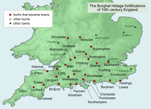
Eorpeburnan was the first place listed in an old document called the Burghal Hidage. This document was made around the late 800s or early 900s. It listed 31 strong, fortified towns in Wessex, a kingdom in ancient England. The Burghal Hidage showed where these forts were. It also explained how big their defenses were and how many soldiers they needed. Eorpeburnan was given a "hidage" of 324. A hide was a way to measure land for taxes. We don't know exactly where Eorpeburnan was located today. But experts have suggested a few possible places.
Contents
Why Were These Forts Built?
Eorpeburnan was one of 31 fortified places, called burhs, in the old Kingdom of Wessex. These burhs were listed in the document known as the Burghal Hidage. Frederic William Maitland gave it this name in 1897.
This network of burhs was part of Alfred the Great's plan. He wanted to protect his kingdom from the Vikings. The Vikings were raiding and invading England often.
The burhs were placed in special spots. They guarded the main roads and rivers that Vikings might use to attack Wessex. They were also safe places for people to go. Most Anglo-Saxon villagers lived no more than 20 miles (32 km) from their closest burh.
These burhs also became busy market towns. People could trade goods safely there. They were also places where coins were made. This was especially true after the year 973. Around that time, new coins were made every five years or so.
What Does the Name Eorpeburnan Mean?
The name Eorpeburnan has two parts. The first part, Eorpe~, might be an old personal name. Or it could mean "dark" in Old English. The second part, ~burnan, most likely means "stream". So, it could mean "Eorpe's stream" or "dark stream".
Where Was Eorpeburnan Located?
We do not know the exact spot of Eorpeburnan today. But the forts in the Burghal Hidage were about 40 miles apart. They were listed in a clockwise direction around Wessex. Eorpeburnan was the very first one listed. This helps us guess its general area.
The Anglo-Saxon Chronicle is an old history book. It says that in 892, a "great host of the Danes" arrived. They came up the Limen river with 250 ships. The chronicle also says they attacked a fort that was not yet finished.
Could It Be Castle Toll?
Some historians think the unfinished fort was Castle Toll. This site is in Newenden, Kent. However, other historians disagree. They have reasons why Castle Toll might not be Eorpeburnan:
- The Burghal Hidage did not plan for the defense of Kent.
- The River Limen might have been too narrow for Viking warships at Castle Toll.
- Castle Toll was hard to reach. It did not offer the usual benefits of a burh.
- Digs at the site showed the fort's building style was not typical of Anglo-Saxon work.
Could It Be Rye?
The town of Rye has also been suggested as the site of Eorpeburnan. Rye is in Sussex. The Burghal Hidage did plan for the defense of Sussex. The second place listed after Eorpeburnan was Hastings, which is west of Rye.
However, there is not much proof of Anglo-Saxon life in Rye. An excavation in the 1980s found an old ditch. But experts could not tell how old it was. A bigger study was done in the 1800s. This was when more old structures were still in place.
Historians have figured out the length of the wall for each burh. They used the numbers given in the Burghal Hidage. The length of the town ditch in Rye matches well with the hidage listed for Eorpeburnan.
 | Shirley Ann Jackson |
 | Garett Morgan |
 | J. Ernest Wilkins Jr. |
 | Elijah McCoy |


