Farmer's Castle facts for kids
Quick facts for kids Farmer's Castle |
|
|---|---|
| Part of the Northwest Territory of the United States | |
| Belpre, Ohio | |

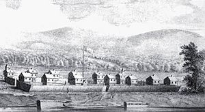
Farmer's Castle fortification at Belpre, Ohio
|
|
| Coordinates | 39°16′17″N 81°34′33″W / 39.271368°N 81.575891°W |
| Site history | |
| Built | 1791 |
| Battles/wars | Northwest Indian War |
| Garrison information | |
| Past commanders |
Nathaniel Goodale, Nathaniel Cushing |
| Occupants | Ohio Company of Associates |
Farmer's Castle was a strong fort built by early American settlers. It stood on the Ohio River, across from the Little Kanawha River. This fort was about 15 miles downriver from Marietta, Ohio. Marietta was the first European-American town in the Northwest Territory.
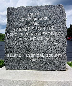
A group of pioneers from the Ohio Company of Associates built the fort. They had explored the land in the winter of 1788-89. In April 1789, they moved from Marietta to their new farms. They named their settlement Belle-prairie, which is now Belpre, Ohio. The settlers started building Farmer's Castle in January 1791. They needed protection during the Northwest Indian War. The fort was built next to an island later called Blennerhassett Island.
Contents
Why Was Farmer's Castle Built?
Farmer's Castle was a very important defensive structure. It protected the pioneers living in Belpre during a time of conflict. The Northwest Indian War was happening, and settlers needed safe places. The fort helped keep families safe from attacks.
Building a Strong Fort
The settlers began building Farmer's Castle in January 1791. They worked very hard and quickly. Their lives depended on finishing the fort. As soon as a blockhouse was ready, families moved in.
The fort had thirteen blockhouses arranged in two rows. There was a wide street between them. Each blockhouse was about 20 feet square at the bottom. The upper part was a bit larger, about 22 feet square. This design meant the top floor hung over the bottom. This helped protect the doors and windows below during an attack.
The blockhouses were made from round logs, about a foot thick. The gaps between the logs were carefully filled with mortar. Doors and window shutters were made of thick oak planks. Strong wooden bars secured them from the inside.
How They Built It
Heavy logs were pulled by ox-teams. Lighter materials for roofs and gates were dragged on hand sleds. Men pulled these sleds with ropes. A few inches of snow on the ground made it easier to move materials.
The fort also had tall fences called palisades. These were made from oak trees about a foot thick. Each picket was 14 feet long and set 4 feet deep in the ground. This left them 10 feet high, too tall for an enemy to climb without a ladder. The smooth side of the pickets faced outward. Strong wooden pieces held them in place from the inside.
The spaces between the blockhouses were filled with these pickets. This created a continuous wall around the settlement. The entire enclosure was about 80 rods long and 6 rods wide. The palisades on the river side extended over the bank. They were sloped to allow air to flow through during hot summers.
Other Forts in the Region
Other fortified settlements were built in the area too. Upriver from Marietta, near the Muskingum River, United States troops built Fort Harmar. The Ohio Company of Associates also built Campus Martius and Picketed Point Stockade. Further up the Muskingum River, other settlers built Fort Frye. This fort later became modern-day Beverly, Ohio. These forts all helped protect settlers during the Northwest Indian War.
 | Percy Lavon Julian |
 | Katherine Johnson |
 | George Washington Carver |
 | Annie Easley |


