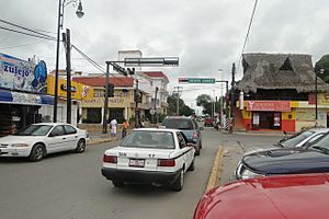
Felipe Carrillo Puerto, Quintana Roo facts for kids
Quick facts for kids
Felipe Carrillo Puerto
|
|
|---|---|
 |
|
| Country | Felipe Santiago Carrillo Puerto |
| State | Quintana Roo |
| Municipality | Felipe Carrillo Puerto |
| Named for | [[]] |
| Elevation | 20 m (70 ft) |
| Population
(2010)
|
|
| • Total | 25,744 |
| Demonym(s) | Carrilloportense |
| Time zone | UTC-5 (Eastern Standard Time) |
| Climate | Aw |
Felipe Carrillo Puerto is an important city in the Mexican state of Quintana Roo. It is the main city and administrative center of the Felipe Carrillo Puerto Municipality. In 2010, about 25,744 people lived there. Most of these people are of Maya descent, meaning they are descendants of the ancient Maya civilization.
Just east of the city, you'll find the Sian Kaʼan Biosphere Reserve. This is a huge natural area protected for its amazing plants and animals.
Contents
History of Felipe Carrillo Puerto
The city of Felipe Carrillo Puerto was started in 1850. It was founded by independent Maya people during a time called the Caste War of Yucatán. This was a big conflict where the Maya people fought for their independence.
At first, the city was known as Chan Santa Cruz. In 1901, Mexican soldiers from the Federal Army took control of the city. After this, its name was changed to "Santa Cruz del Bravo."
Later, in 1930, the city got its current name, "Felipe Carrillo Puerto." This was done to honor a famous Mexican politician named Felipe Carrillo Puerto. He was an important leader who worked to improve life for the people of Yucatán.
Geography and Climate
What is the Climate Like in Felipe Carrillo Puerto?
Felipe Carrillo Puerto has a tropical climate. This means it's generally warm all year round. It also experiences a lot of rain, especially during certain months.
The weather patterns are carefully recorded. You can see details about the temperature, rainfall, and humidity in the table below. These records help scientists understand the local environment.
| Climate data for Felipe Carrillo Puerto, Quintana Roo (1951–2010) | |||||||||||||
|---|---|---|---|---|---|---|---|---|---|---|---|---|---|
| Month | Jan | Feb | Mar | Apr | May | Jun | Jul | Aug | Sep | Oct | Nov | Dec | Year |
| Record high °C (°F) | 37.0 (98.6) |
39.0 (102.2) |
42.0 (107.6) |
44.0 (111.2) |
40.5 (104.9) |
40.0 (104.0) |
39.0 (102.2) |
38.5 (101.3) |
40.0 (104.0) |
38.0 (100.4) |
37.5 (99.5) |
39.5 (103.1) |
44.0 (111.2) |
| Mean daily maximum °C (°F) | 28.8 (83.8) |
29.9 (85.8) |
31.7 (89.1) |
33.2 (91.8) |
34.0 (93.2) |
33.1 (91.6) |
33.2 (91.8) |
33.4 (92.1) |
33.0 (91.4) |
31.8 (89.2) |
30.3 (86.5) |
29.0 (84.2) |
31.8 (89.2) |
| Daily mean °C (°F) | 22.9 (73.2) |
23.6 (74.5) |
25.2 (77.4) |
26.7 (80.1) |
28.0 (82.4) |
27.8 (82.0) |
27.9 (82.2) |
27.8 (82.0) |
27.7 (81.9) |
26.5 (79.7) |
24.8 (76.6) |
23.3 (73.9) |
26.0 (78.8) |
| Mean daily minimum °C (°F) | 17.0 (62.6) |
17.2 (63.0) |
18.7 (65.7) |
20.3 (68.5) |
22.0 (71.6) |
22.5 (72.5) |
22.5 (72.5) |
22.2 (72.0) |
22.4 (72.3) |
21.2 (70.2) |
19.2 (66.6) |
17.7 (63.9) |
20.2 (68.4) |
| Record low °C (°F) | 4.5 (40.1) |
7.0 (44.6) |
8.0 (46.4) |
6.0 (42.8) |
13.5 (56.3) |
5.0 (41.0) |
15.5 (59.9) |
6.0 (42.8) |
17.0 (62.6) |
11.5 (52.7) |
9.0 (48.2) |
7.5 (45.5) |
4.5 (40.1) |
| Average precipitation mm (inches) | 54.4 (2.14) |
50.2 (1.98) |
38.5 (1.52) |
40.4 (1.59) |
117.0 (4.61) |
171.8 (6.76) |
150.2 (5.91) |
160.3 (6.31) |
210.4 (8.28) |
170.8 (6.72) |
84.2 (3.31) |
57.0 (2.24) |
1,305.2 (51.39) |
| Average precipitation days (≥ 0.1 mm) | 8.4 | 5.7 | 4.1 | 3.6 | 7.8 | 13.6 | 13.9 | 14.9 | 17.2 | 15.4 | 10.4 | 8.9 | 123.9 |
| Average relative humidity (%) | 76 | 75 | 71 | 69 | 71 | 77 | 76 | 78 | 79 | 80 | 78 | 78 | 76 |
| Mean monthly sunshine hours | 213 | 245 | 273 | 273 | 258 | 215 | 232 | 232 | 196 | 216 | 215 | 201 | 2,769 |
| Source 1: Servicio Meteorológico National (humidity 1981–2000) | |||||||||||||
| Source 2: Deutscher Wetterdienst (sun, 1961–1990) | |||||||||||||
See also
 In Spanish: Felipe Carrillo Puerto (Quintana Roo) para niños
 | Misty Copeland |
 | Raven Wilkinson |
 | Debra Austin |
 | Aesha Ash |


