
Fitzroy Crossing, Western Australia facts for kids
Quick facts for kids Fitzroy CrossingWestern Australia |
|||||||||
|---|---|---|---|---|---|---|---|---|---|

The former road bridge over the Fitzroy River in Fitzroy Crossing
|
|||||||||

Fitzroy Crossing
Location in Western Australia
|
|||||||||
| Established | 1900s | ||||||||
| Postcode(s) | 6765 | ||||||||
| Elevation | 114 m (374 ft) | ||||||||
| Area | [convert: needs a number] | ||||||||
| LGA(s) | Shire of Derby-West Kimberley | ||||||||
| State electorate(s) | Kimberley | ||||||||
| Federal Division(s) | Durack | ||||||||
|
|||||||||
Fitzroy Crossing is a small town in the Kimberley region of Western Australia. It's about 400 kilometers (250 miles) east of Broome. The town sits on a small hill. It is surrounded by the wide floodplains of the Fitzroy River. The Margaret River also joins the Fitzroy nearby.
In 2016, about 1,300 people lived in Fitzroy Crossing. Many more people live in nearby Aboriginal communities. Most people in the Fitzroy Valley are Indigenous Australians. Important jobs in the area include tourism, working on cattle stations, and mining.
Contents
History of Fitzroy Crossing
The land around Fitzroy Crossing has been home to many Aboriginal language groups for a very long time. The main group when the town was settled was the Bunuba people. They are known as the river and hill people. Their land stretched across the ranges and rivers.
Other groups in the area include the Gooniyandi people. They lived on the other side of the Fitzroy River. The Nyigina people lived on the plains. Further south were the Walmajarri people from the Great Sandy Desert. Other traditional owners are the Njikena, Konejani, and Waladjari peoples.
Early European Exploration and Settlement
One of the first European explorers in the Kimberley area was Alexander Forrest. In 1879, he followed the Fitzroy River. After his trip, the first sheep stations were set up around 1882. Cattle stations soon followed.
The area was settled in 1886 by Dan MacDonald. He started the Fossil Downs cattle station. He brought his cattle on a long journey from New South Wales.
Bridges and Floods
Fitzroy Crossing got its first bridge in 1935. A stronger bridge was built in 1958. However, this bridge often closed for months during the rainy season. In 1974, a new bridge was built about 3 kilometers (1.9 miles) south. This moved the main part of the town.
In January 2023, this bridge was badly damaged by record floods. A new, even stronger bridge was built and opened in December 2023. The town can sometimes flood, as it did in 2002, 2011, and 2023.
The town was officially named in 1975. However, it had been shown on maps since 1903.
Recent Developments
In 2006, the Fitzroy Crossing Bull Sale began. This is an annual cattle auction. People come from all over Australia to take part.
In 2009, the only grocery store in town was destroyed by fire. A new shopping center was built and opened in 2011. Also in 2009, the local school moved. It was renamed Fitzroy Valley District High School.
Community Support and Services
Fitzroy Crossing is an important center for the communities in the Fitzroy Valley. Many people come to town for different activities. They might visit family, go fishing, or play sports. People also come for shopping or appointments at the hospital. The town has many services because it is a central place for these communities.
Community Efforts
From 1951 to 1955, a mission helped set up a basic school and health center. These services were later taken over by the government. They have grown to what they are today.
Community leaders have worked to improve life in Fitzroy Crossing. In 2007, local people asked for rules about selling alcohol. These rules have helped the town. For example, fewer people needed emergency medical care. There was also less family conflict. School attendance also went up.
The government has also supported the community. They have helped people manage their money. This helps families plan for the future. It also helps them get involved in the community. Community projects have also been set up to help families and children.
There has been concern about children being out late at night. Community leaders are working on solutions. They are looking at safe places for children. They also want elders to guide young people. More activities and opportunities for youth are also being planned.
Facilities
Fitzroy Crossing has many useful facilities. There are two roadhouses and a 24-hour diesel station. You can find a supermarket, post office, and newsagent. There are also clothes shops, places to stay, mechanics, and cafes.
The town also has a swimming pool. There are covered basketball courts and a grassed Australian rules football oval. Many grassed areas are available for public use.
Bayulu Community is a nearby community. It is about 12 kilometers (7.5 miles) southeast along the Great Northern Highway.
Sport
The Central Kimberley Football Association is based in Fitzroy Crossing. Six clubs from local communities play in a regular season. This football competition started in 1991.
Media
Fitzroy Crossing is home to Wangki Radio. This is a small Aboriginal community radio station. It broadcasts on 936AM to the town and nearby communities. Wangki Radio shares news, weather, and road reports. It also plays music for people in remote parts of the Kimberley.
The ABC also broadcasts two radio stations in Fitzroy. These are ABC Local Radio 106.1 and ABC Radio National 107.7. Fitzroy Crossing also receives all regional Western Australian digital television stations.
Climate
Fitzroy Crossing has a very hot climate. It is a mix of monsoonal and semi-arid weather. The average highest temperature is around 30°C (86°F) in July. It can reach 41°C (106°F) in November. The hottest day ever recorded was 47.9°C (118.2°F) in January 1969. The coldest night was 0.6°C (33.1°F) in June 1971.
Most of the rain falls between December and March. This is the summer and early autumn. The months from April to October are usually dry. These months are also cooler.
| Climate data for Fitzroy Crossing Comparison/Fitzroy Crossing Aerodrome | |||||||||||||
|---|---|---|---|---|---|---|---|---|---|---|---|---|---|
| Month | Jan | Feb | Mar | Apr | May | Jun | Jul | Aug | Sep | Oct | Nov | Dec | Year |
| Record high °C (°F) | 47.9 (118.2) |
45.0 (113.0) |
43.9 (111.0) |
42.2 (108.0) |
40.1 (104.2) |
37.0 (98.6) |
37.3 (99.1) |
39.0 (102.2) |
42.9 (109.2) |
45.1 (113.2) |
46.1 (115.0) |
46.5 (115.7) |
47.9 (118.2) |
| Mean daily maximum °C (°F) | 37.7 (99.9) |
36.4 (97.5) |
36.9 (98.4) |
36.2 (97.2) |
32.1 (89.8) |
29.9 (85.8) |
29.6 (85.3) |
32.5 (90.5) |
36.2 (97.2) |
39.4 (102.9) |
40.6 (105.1) |
40.1 (104.2) |
35.6 (96.1) |
| Mean daily minimum °C (°F) | 24.7 (76.5) |
24.1 (75.4) |
23.1 (73.6) |
19.6 (67.3) |
15.7 (60.3) |
12.2 (54.0) |
10.7 (51.3) |
12.7 (54.9) |
17.2 (63.0) |
21.4 (70.5) |
24.2 (75.6) |
25.2 (77.4) |
19.2 (66.6) |
| Record low °C (°F) | 16.4 (61.5) |
17.8 (64.0) |
14.8 (58.6) |
10.9 (51.6) |
5.6 (42.1) |
0.6 (33.1) |
1.6 (34.9) |
3.4 (38.1) |
5.0 (41.0) |
11.2 (52.2) |
14.3 (57.7) |
15.6 (60.1) |
0.6 (33.1) |
| Average precipitation mm (inches) | 152.8 (6.02) |
139.1 (5.48) |
81.5 (3.21) |
20.1 (0.79) |
11.1 (0.44) |
8.4 (0.33) |
6.2 (0.24) |
1.4 (0.06) |
1.8 (0.07) |
5.4 (0.21) |
25.7 (1.01) |
87.3 (3.44) |
540.1 (21.26) |
| Average precipitation days | 12.3 | 10.7 | 7.2 | 2.0 | 1.5 | 1.0 | 0.7 | 0.3 | 0.4 | 1.3 | 4.0 | 8.3 | 49.7 |
Images for kids
-
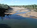
Fitzroy River at Fitzroy Crossing
-
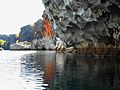
The Fitzroy River at Danggu Gorge


