


- This page was last modified on 17 October 2025, at 11:18. Suggest an edit.
Fort Street–Pleasant Street and Norfolk & Western Railroad Viaduct facts for kids
|
Fort Street—Pleasant Street and Norfolk & Western Railroad Viaduct
|
|

Pleasant Street at Fort, looking north
|
|

Location in Michigan

Location in the United States
|
|
| Location | Detroit, Michigan |
|---|---|
| Built | 1928 |
| Architect | Wayne County Road Commission |
| MPS | Highway Bridges of Michigan MPS |
| NRHP reference No. | 00000116 |
| Added to NRHP | February 18, 2000 |
The Fort Street–Pleasant Street and Norfolk & Western Railroad Viaduct is a large bridge in Detroit, Michigan. It carries six lanes of Fort Street over Pleasant Street. It also crosses over many railroad tracks. These tracks are used by different railway companies.
The bridge is located near the Rouge River. It sits on the edge of the Boynton and Oakwood Heights neighborhoods. This important bridge was added to the National Register of Historic Places in 2000. It had major repairs and construction work in 2010 and 2011. During this time, Fort Street was made a bit narrower north of the bridge.
Contents
Building a Better Bridge: The Fort Street Viaduct Story
The area around Fort Street changed a lot in the early 1900s. It used to be a place with homes. But it slowly became a busy industrial area. One old newspaper said that Fort Street went from a "social center" to a "great business artery." This meant that factories and businesses took over.
Many important factories were built nearby. The Ford River Rouge Complex, for example, is just upstream from the Fort Road river crossing. This made both Fort Road and the railway tracks very important for transportation in Detroit.
Upgrading Roads for More Traffic
In the 1920s, Fort Road was chosen for a big upgrade. It was going to become a "superhighway." The city, county, and state worked together on these upgrades. They made the roads wider and added lights for nighttime driving.
More cars on the road also meant more traffic jams and accidents. This was especially true where roads crossed railroad tracks. In 1928, officials decided to build bridges to separate roads from train tracks. This would make travel safer and smoother. The Fort Road bridge project was the very first one to start.
Designing a Huge Bridge
Building this bridge was a big challenge. It needed to be very long to cross two streets and twelve railroad tracks. It also had to be wide enough for two lanes of traffic, each 40-foot (12 m) wide. This made the project very expensive and took a long time to plan.
Construction finally began in the summer of 1928. The entire structure was finished in 1930. It was a huge achievement for its time.
The Bridge's Look and Features
When it was first built, the bridge had fancy details. It featured an "ornamental concrete handrail" with "ornamental concrete lamp posts." These were meant to make the bridge look beautiful and be well-lit at night.
Over the years, some parts of the railing have changed. The original urn-shaped balusters (small posts) were replaced with solid concrete panels. However, other parts of the railing, like the octagonal lamp posts, are still there. Even with these small changes, the bridge remains a very important and impressive structure.
Why the Fort Street Viaduct is Important
The Fort Street Viaduct is special because of its design and its huge size. Usually, it was cheaper to build a railroad bridge over a street. But at the Fort Road crossing, there were so many train tracks. Building a subway for the road under all those tracks would have been too difficult.
This bridge is 2,800 feet (850 m) long and has an 80-foot (24 m) wide roadway. It was the biggest and most ambitious project in the 1920s plan to separate roads and train tracks. The Fort Street Viaduct shows how important this program was. Planners wanted to make driving safer and reduce traffic delays.
Images for kids
-
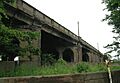
Section of bridge over the Norfolk & Western Railroad
-
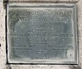
Plaque on Fort St bridge over Pleasant Street
-
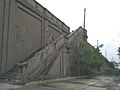
Stairs leading up from Pleasant Street to Fort Street