Gambela Region facts for kids
Quick facts for kids
Gambela Peoples' Region
ጋምቤላ ሕዝቦች ክልል
|
|||
|---|---|---|---|
|
Regional State
|
|||
|
|||

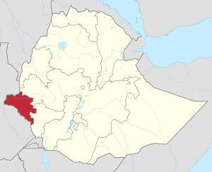
Map of Ethiopia showing Gambela Region
|
|||
| Country | Ethiopia | ||
| Capital | Gambela | ||
| Area | |||
| • Total | 29,782.82 km2 (11,499.21 sq mi) | ||
| Population
(2017)
|
|||
| • Total | 435,999 | ||
| • Density | 14.639279/km2 (37.91556/sq mi) | ||
| ISO 3166 code | ET-GA | ||
Gambela is a special region in Ethiopia, a country in Africa. It is also known as the Gambela Peoples' Region. The main city and capital of this region is also called Gambela.
This region is located between two important rivers, the Baro and the Akobo River. These rivers are very important for the people and wildlife living there.
About Gambela Region
Gambela is one of the eleven regions that make up Ethiopia. Each region has its own government and is designed to represent the different groups of people living in Ethiopia.
Nature and Wildlife
A big part of Gambela is covered by Gambela National Park. This park protects about 15% of the region's land. It is home to many different animals and plants. National parks help keep nature safe for future generations.
How Gambela is Organized
The Gambela region is divided into smaller areas called zones. These zones help manage the region more easily. The main zones in Gambela are:
- Anuak Zone
- Mezhenger Zone
- Nuer Zone
- Itang (woreda)
These zones are named after the main ethnic groups living in those areas.
See also
 In Spanish: Región de Gambela para niños
 | Anna J. Cooper |
 | Mary McLeod Bethune |
 | Lillie Mae Bradford |


