
Gash-Barka Region facts for kids
Quick facts for kids
Gash-Barka Zone
Zoba Gash-Barka
ዞባ ጋሽ ባርካ منطقة القاش وبركا Regione di Gasc-Barca
|
|
|---|---|
|
Zoba
|
|

Gash-Barka Region in Eritrea
|
|
| Country | Eritrea |
| Capital | Barentu |
| Area | |
| • Total | 33,200 km2 (12,800 sq mi) |
| Population | |
| • Total | 1,103,742 |
| • Density | 33.25/km2 (86.10/sq mi) |
| ISO 3166 code | ER-GB |
Gash-Barka is one of the six main regions in Eritrea, a country located in the Horn of Africa. Think of it like a large state or province within a country. Its capital city is Barentu. This region is known for its diverse landscapes and many different communities.
Other important towns in Gash-Barka include Agordat, which used to be the capital, along with Molki, Sebderat, and Teseney.
Contents
What is Gash-Barka?
Gash-Barka is a big region in western Eritrea. It covers a large area of about 33,200 square kilometers (which is about 12,800 square miles). This makes it one of the biggest regions in the country.
The region is named after two important rivers: the Gash River and the Barka River. These rivers are very important for the people living here, especially for farming.
People and Culture
Gash-Barka is home to many different ethnic groups. This means you'll find a rich mix of cultures, languages, and traditions here. People from various backgrounds live and work together, making the region very vibrant.
Many people in Gash-Barka work in farming and raising animals. The land is often fertile, especially near the rivers, which helps with growing crops.
Towns and Subregions
The region is divided into smaller areas called subregions. Each subregion has its own main town or city. This helps manage the different parts of Gash-Barka.
Here are the subregions that make up Gash-Barka:
- Agordat City
- Barentu City
- Dghe
- Forto
- Gogne
- Haykota
- Logo Anseba
- Mensura
- Mogolo
- Molki
- Omhajer
- Shambuko
- Tesseney
- Upper Gash
Geography and Climate
Gash-Barka has a varied landscape. You can find flat plains, rolling hills, and areas with more rugged terrain. The climate is generally hot, especially during the dry season. However, the rivers help to make some areas greener and more suitable for agriculture.
The Gash River, also known as the Mareb River, flows through the region. It's often dry for part of the year but fills up during the rainy season. The Barka River is another major waterway that supports life in the area.
Images for kids
-
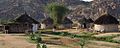
Early morning in a Gash Barka village
-
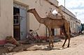
Barentu

See also
 In Spanish: Región de Gash-Barka para niños
