
Gaspésie National Park facts for kids
Quick facts for kids Parc national de la Gaspésie |
|
|---|---|
|
IUCN Category II (National Park)
|
|

Summit of Mount Jacques-Cartier
|
|

Parc national de la Gaspésie
Location in Quebec
|
|
| Location | La Haute-Gaspésie and La Matanie RCMs, Quebec, Canada |
| Nearest city | Sainte-Anne-des-Monts |
| Area | 80,200 hectares |
| Established | November 25, 1981 |
| Governing body | Sépaq |
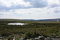
Gaspésie National Park (also known as Parc national de la Gaspésie in French) is a special nature park in Quebec, Canada. It's located in the middle of the Gaspé peninsula, south of the town of Sainte-Anne-des-Monts.
This park is home to some amazing things! It has Mont Jacques-Cartier, which is the highest mountain in the Canadian Appalachian Mountains. It stands tall at 1,270 meters (about 4,167 feet) above sea level. You can also find a unique animal here: the caribou! This park is the only place south of the Saint Lawrence River in Canada where you can see these wild reindeer.

Contents
Mountain Ranges and How They Formed
Gaspésie National Park has two main mountain ranges. Each range formed in a different way, making them unique.
The Ancient Chic-Choc Mountains
To the west of the Sainte-Anne River, you'll find the Chic-Choc Mountains. These mountains are incredibly old, about 600 million years! They were mostly created by volcanoes erupting underwater a very long time ago.
The Younger McGerrigle Mountains
The McGerrigle Mountains are much younger, only about 380 million years old. These mountains formed when hot, melted rock (magma) pushed up from deep inside the Earth. This magma cooled down underground, forming a huge block of granite. Over millions of years, the softer rocks above this granite wore away, leaving the strong granite mountains we see today. Mont Jacques-Cartier is part of this range.
Park Climate and Weather
The weather in Gaspésie National Park is quite different from other parts of Quebec. This is because the park is high up in the mountains and close to the Saint Lawrence River.
Temperatures and Precipitation
For example, Mount Logan, which is 1,150 meters (about 3,773 feet) high, has an average temperature of about -3.6 degrees Celsius (25.5 degrees Fahrenheit) each year. These cold temperatures, along with the lower air pressure at high altitudes, cause a lot of moisture to turn into rain or snow. In fact, these mountains get more rain and snow than any other region in Quebec!
Images for kids
-
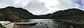
Lac aux Américains
-

Mountains, winter 2008-2009
-
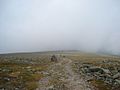
Mount Jacques-Cartier summit
-
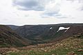
Grande Cuve, Mount Albert
-
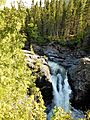
Sainte-Anne waterfall
-
Lake on the plateau at the summit of Mount Albert


