
Geography of Arizona facts for kids


Arizona is a state located in the southwestern part of the United States. It is famous for its amazing and varied landscapes. You can find deep canyons, deserts both high and low, many natural rock formations, and mountains formed by volcanoes. Arizona shares land borders with Utah to the north, the Mexican state of Sonora to the south, New Mexico to the east, and Nevada to the northwest. It also has water borders with California and the Mexican state of Baja California to the southwest along the Colorado River. Arizona is one of the Four Corners states, meaning it meets Colorado at a single point.
Arizona is the sixth largest U.S. state. It covers about 113,998 square miles (295,240 square kilometers). Only a tiny part of this area, about 0.3%, is water. This makes Arizona the state with the second lowest amount of water. Arizona stretches about 335 miles (540 km) at its widest and 390 miles (630 km) at its longest. Its average height above sea level is about 4,000 feet (1,200 meters). The geographic center of Arizona is in Yavapai County. This is about 55 miles (89 km) east-southeast of Prescott.
Contents
Arizona's Counties and Cities

Arizona is divided into 15 main areas called counties. It also has 90 official cities and towns. A large number of people, about 60%, live in Maricopa County. In 2020, over 4.4 million people lived there. Maricopa County is the fourth most populated county in the entire United States. It has more people than 24 other U.S. states! The main city in Maricopa County is Phoenix. Phoenix is Arizona's biggest city and its capital.
The next most populated area is Pima County. In 2020, it had over 1 million people. The main city there is Tucson, where almost everyone in the county lives. Together, nearly 80% of Arizona's people live in Maricopa or Pima counties. These two counties are very important in state decisions because of their large populations.
About 15% of Arizona's land is privately owned. The rest is managed by different groups. These include the Forest Service, National Park Service, and Native American reservations. There are also military areas and wild lands managed by the Bureau of Land Management. Arizona is home to 21 federally recognized tribes. These tribes have their own governments and manage their lands. The largest of these is the Navajo Nation. It covers a huge area in northeastern Arizona, plus parts of New Mexico and Utah. In 2020, it had a population of 165,158.
Arizona's Weather and Climate

Arizona is a big state with many different elevations. This means it has many different local weather conditions. Most of Arizona gets little rain. It is often described as having a dry or partially dry climate. The northern parts of the state and the mountains are usually cooler. The southwestern parts of the state are warm all year round.
Rainfall Patterns

Rainfall in Arizona depends on how high up a place is and the time of year. The most rain falls in early winter. This is when storms from the Pacific Ocean move across the state. More rain also comes in the summer. During summer, moist winds from the southeast bring water from the Gulf of Mexico. Summer rains often come as thunderstorms. These happen when the ground gets very hot and moist air rises along mountains. Thunderstorms can bring strong winds, short dust storms, and sometimes hail. The heaviest rain is in the mountains of central and southeastern Arizona. The driest areas are in southwestern Arizona.
The number of rainy days can be around 70 in Flagstaff but only 15 in Yuma. The highest parts of Arizona get up to 30 inches (760 mm) of rain each year. The southern slopes of the Mogollon Rim and the southeast get between 15 and 20 inches (380 and 510 mm). The driest part of the state is the southwest, with less than 3 inches (76 mm) of rain a year. The northeastern Colorado Plateau is in a rain shadow and gets between 4.5 and 10 inches (110 and 250 mm).
Average humidity changes from 55% in Flagstaff to 23% in Yuma. Because of high temperatures, low humidity, and lots of sunshine, water evaporates quickly in Arizona. Lakes can lose about 80 inches (2,000 mm) of water a year in the southwest. In the northeast, they lose about 50 inches (1,300 mm). During El Niño years, Arizona winters are wetter than usual. This is because the Pacific jet stream moves further south. During La Niña years, winters are drier than normal.
Snow in Arizona
Even though Arizona is known for its warm deserts, snow is common in some parts. From November to March, storms from the Pacific Ocean bring heavy snow to the mountains. This happens in central, northern, and southeastern Arizona. Moderate snow can even fall as far south as Nogales, Arizona. This city is on the border with Mexico. It gets freezing temperatures at night during winter.
The edges of the Grand Canyon also get snow in winter. This is because they are very high up. The South Rim of the Grand Canyon is about 7,000 feet (2,100 meters) high. It gets about 60 inches (1.5 meters) of snow each year. The North Rim is over 8,000 feet (2,400 meters) high. It receives about 144 inches (3.7 meters) of snow.
Arizona's Temperatures
| Climate data for Arizona | |||||||||||||
|---|---|---|---|---|---|---|---|---|---|---|---|---|---|
| Month | Jan | Feb | Mar | Apr | May | Jun | Jul | Aug | Sep | Oct | Nov | Dec | Year |
| Record high °F (°C) | 90 (32) |
98 (37) |
112 (44) |
113 (45) |
121 (49) |
128 (53) |
127 (53) |
126 (52) |
123 (51) |
116 (47) |
102 (39) |
92 (33) |
128 (53) |
| Record low °F (°C) | −40 (−40) |
−37 (−38) |
−27 (−33) |
−16 (−27) |
4 (−16) |
13 (−11) |
25 (−4) |
20 (−7) |
11 (−12) |
−9 (−23) |
−30 (−34) |
−36 (−38) |
−40 (−40) |
| Source: https://www.factmonster.com/math-science/weather/arizona-temperature-extremes | |||||||||||||
Arizona's dry climate and clear skies mean temperatures can change a lot. They vary from day to night and from season to season. Parts of Arizona in the Sonoran Desert are warm during the day all year. Other areas get cold regularly in certain seasons. For example, in Yuma, daily temperatures range from 43 to 67°F (6 to 19°C) in January. In July, they range from 81 to 107°F (27 to 42°C). In Flagstaff, daily temperatures are 14 to 41°F (-10 to 5°C) in January. In July, they are 50 to 81°F (10 to 27°C).
The highest temperature ever recorded in Arizona was 128°F (53°C). This happened in Lake Havasu City on June 29, 1994, and July 5, 2007. The lowest temperature was -40°F (-40°C). This was recorded at Hawley Lake on January 7, 1971.
Detailed Weather for Arizona Cities
| Climate data for Flagstaff Pulliam Airport, Arizona (1981–2010 normals, extremes 1898–present) | |||||||||||||
|---|---|---|---|---|---|---|---|---|---|---|---|---|---|
| Month | Jan | Feb | Mar | Apr | May | Jun | Jul | Aug | Sep | Oct | Nov | Dec | Year |
| Record high °F (°C) | 66 (19) |
71 (22) |
73 (23) |
80 (27) |
89 (32) |
96 (36) |
97 (36) |
93 (34) |
91 (33) |
85 (29) |
74 (23) |
68 (20) |
97 (36) |
| Mean daily maximum °F (°C) | 42.5 (5.8) |
44.8 (7.1) |
50.4 (10.2) |
58.2 (14.6) |
68.1 (20.1) |
77.9 (25.5) |
81.2 (27.3) |
78.4 (25.8) |
72.9 (22.7) |
62.0 (16.7) |
50.5 (10.3) |
42.5 (5.8) |
60.8 (16.0) |
| Mean daily minimum °F (°C) | 17.3 (−8.2) |
19.3 (−7.1) |
23.6 (−4.7) |
28.5 (−1.9) |
35.0 (1.7) |
41.9 (5.5) |
50.9 (10.5) |
50.1 (10.1) |
42.0 (5.6) |
31.5 (−0.3) |
22.9 (−5.1) |
16.8 (−8.4) |
31.7 (−0.2) |
| Record low °F (°C) | −30 (−34) |
−23 (−31) |
−16 (−27) |
−2 (−19) |
7 (−14) |
22 (−6) |
32 (0) |
24 (−4) |
20 (−7) |
−2 (−19) |
−13 (−25) |
−23 (−31) |
−30 (−34) |
| Average precipitation inches (mm) | 2.05 (52) |
2.16 (55) |
2.12 (54) |
1.15 (29) |
0.63 (16) |
0.36 (9.1) |
2.61 (66) |
3.11 (79) |
2.38 (60) |
1.66 (42) |
1.76 (45) |
1.87 (47) |
21.86 (554.1) |
| Average snowfall inches (cm) | 23.2 (59) |
20.9 (53) |
20.7 (53) |
7.1 (18) |
0.7 (1.8) |
0 (0) |
0 (0) |
0 (0) |
trace | 1.5 (3.8) |
10.7 (27) |
16.9 (43) |
101.7 (258) |
| Average precipitation days (≥ 0.01 in) | 7.6 | 8.1 | 8.2 | 5.8 | 4.5 | 2.6 | 11.6 | 14.0 | 7.9 | 5.5 | 4.9 | 7.0 | 87.7 |
| Average snowy days (≥ 0.1 in) | 7.5 | 6.9 | 6.6 | 3.0 | 0.8 | 0 | 0 | 0 | 0 | 0.6 | 3.0 | 6.5 | 34.9 |
| Average relative humidity (%) | 61.9 | 59.5 | 54.9 | 46.5 | 39.4 | 33.6 | 51.1 | 58.1 | 54.7 | 52.6 | 56.9 | 60.6 | 52.5 |
| Mean monthly sunshine hours | 231.7 | 228.6 | 286.3 | 321.0 | 369.5 | 371.8 | 324.2 | 311.9 | 298.5 | 282.8 | 229.3 | 219.8 | 3,475.4 |
| Percent possible sunshine | 74 | 75 | 77 | 82 | 85 | 86 | 73 | 75 | 80 | 81 | 74 | 72 | 78 |
| Source: NOAA (relative humidity 1961–1990, sun 1973–1990) | |||||||||||||
| Climate data for Phoenix Int'l, Arizona (1981–2010 normals, extremes 1895–present) | |||||||||||||
|---|---|---|---|---|---|---|---|---|---|---|---|---|---|
| Month | Jan | Feb | Mar | Apr | May | Jun | Jul | Aug | Sep | Oct | Nov | Dec | Year |
| Record high °F (°C) | 88 (31) |
92 (33) |
100 (38) |
105 (41) |
114 (46) |
122 (50) |
121 (49) |
117 (47) |
116 (47) |
107 (42) |
96 (36) |
87 (31) |
122 (50) |
| Mean maximum °F (°C) | 78.7 (25.9) |
82.8 (28.2) |
90.0 (32.2) |
98.6 (37.0) |
105.9 (41.1) |
112.5 (44.7) |
114.4 (45.8) |
112.5 (44.7) |
108.6 (42.6) |
100.1 (37.8) |
88.1 (31.2) |
77.1 (25.1) |
115.2 (46.2) |
| Mean daily maximum °F (°C) | 67.2 (19.6) |
70.7 (21.5) |
76.9 (24.9) |
85.2 (29.6) |
94.8 (34.9) |
103.9 (39.9) |
106.1 (41.2) |
104.4 (40.2) |
99.8 (37.7) |
88.5 (31.4) |
75.5 (24.2) |
66.0 (18.9) |
86.6 (30.3) |
| Daily mean °F (°C) | 56.4 (13.6) |
59.7 (15.4) |
65.2 (18.4) |
72.7 (22.6) |
82.1 (27.8) |
90.8 (32.7) |
94.8 (34.9) |
93.6 (34.2) |
88.4 (31.3) |
76.7 (24.8) |
64.1 (17.8) |
55.4 (13.0) |
75.1 (23.9) |
| Mean daily minimum °F (°C) | 45.6 (7.6) |
48.7 (9.3) |
53.5 (11.9) |
60.2 (15.7) |
69.4 (20.8) |
77.7 (25.4) |
83.5 (28.6) |
82.7 (28.2) |
76.9 (24.9) |
64.8 (18.2) |
52.7 (11.5) |
44.8 (7.1) |
63.4 (17.4) |
| Mean minimum °F (°C) | 36.2 (2.3) |
39.4 (4.1) |
43.2 (6.2) |
49.5 (9.7) |
58.0 (14.4) |
68.4 (20.2) |
73.7 (23.2) |
73.7 (23.2) |
67.1 (19.5) |
53.6 (12.0) |
40.8 (4.9) |
34.6 (1.4) |
33.5 (0.8) |
| Record low °F (°C) | 16 (−9) |
24 (−4) |
25 (−4) |
35 (2) |
39 (4) |
49 (9) |
63 (17) |
58 (14) |
47 (8) |
34 (1) |
27 (−3) |
22 (−6) |
16 (−9) |
| Average precipitation inches (mm) | 0.91 (23) |
0.92 (23) |
0.99 (25) |
0.28 (7.1) |
0.11 (2.8) |
0.02 (0.51) |
1.05 (27) |
1.00 (25) |
0.64 (16) |
0.58 (15) |
0.65 (17) |
0.88 (22) |
8.03 (204) |
| Average precipitation days (≥ 0.01 in) | 4.1 | 4.4 | 3.9 | 1.7 | 1.0 | 0.5 | 4.2 | 5.0 | 2.8 | 2.5 | 2.6 | 3.9 | 36.6 |
| Average relative humidity (%) | 50.9 | 44.4 | 39.3 | 27.8 | 21.9 | 19.4 | 31.6 | 36.2 | 35.6 | 36.9 | 43.8 | 51.8 | 36.6 |
| Mean monthly sunshine hours | 256.0 | 257.2 | 318.4 | 353.6 | 401.0 | 407.8 | 378.5 | 360.8 | 328.6 | 308.9 | 256.0 | 244.8 | 3,871.6 |
| Percent possible sunshine | 81 | 84 | 86 | 90 | 93 | 95 | 86 | 87 | 89 | 88 | 82 | 79 | 87 |
| Source: NOAA (relative humidity and sun 1961–1990) , Weather.com | |||||||||||||
| Climate data for Tucson, Arizona (Tucson Int'l), 1981–2010 normals, extremes 1894−present | |||||||||||||
|---|---|---|---|---|---|---|---|---|---|---|---|---|---|
| Month | Jan | Feb | Mar | Apr | May | Jun | Jul | Aug | Sep | Oct | Nov | Dec | Year |
| Record high °F (°C) | 88 (31) |
92 (33) |
99 (37) |
104 (40) |
111 (44) |
117 (47) |
114 (46) |
112 (44) |
107 (42) |
102 (39) |
94 (34) |
85 (29) |
117 (47) |
| Mean daily maximum °F (°C) | 65.5 (18.6) |
68.5 (20.3) |
74.1 (23.4) |
82.1 (27.8) |
91.6 (33.1) |
100.3 (37.9) |
99.7 (37.6) |
97.4 (36.3) |
94.5 (34.7) |
84.8 (29.3) |
73.5 (23.1) |
64.8 (18.2) |
83.1 (28.4) |
| Mean daily minimum °F (°C) | 39.8 (4.3) |
42.2 (5.7) |
46.2 (7.9) |
52.0 (11.1) |
60.5 (15.8) |
69.3 (20.7) |
74.4 (23.6) |
73.3 (22.9) |
68.6 (20.3) |
57.3 (14.1) |
46.1 (7.8) |
39.1 (3.9) |
55.7 (13.2) |
| Record low °F (°C) | 6 (−14) |
17 (−8) |
20 (−7) |
27 (−3) |
32 (0) |
43 (6) |
49 (9) |
55 (13) |
43 (6) |
26 (−3) |
19 (−7) |
10 (−12) |
6 (−14) |
| Average precipitation inches (mm) | 0.94 (24) |
0.86 (22) |
0.73 (19) |
0.31 (7.9) |
0.23 (5.8) |
0.20 (5.1) |
2.25 (57) |
2.39 (61) |
1.29 (33) |
0.89 (23) |
0.57 (14) |
0.93 (24) |
11.56 (294) |
| Average snowfall inches (cm) | 0.3 (0.76) |
0.2 (0.51) |
trace | 0 (0) |
0 (0) |
0 (0) |
0 (0) |
0 (0) |
0 (0) |
0 (0) |
0 (0) |
0.1 (0.25) |
0.6 (1.5) |
| Average precipitation days (≥ 0.01 in) | 4.9 | 4.1 | 3.9 | 2.0 | 1.8 | 1.7 | 9.8 | 9.7 | 4.4 | 3.2 | 2.7 | 4.7 | 52.9 |
| Average snowy days (≥ 0.1 in) | 0.2 | 0.2 | 0 | 0 | 0 | 0 | 0 | 0 | 0 | 0 | 0 | 0.1 | 0.5 |
| Average relative humidity (%) | 48.4 | 42.7 | 37.0 | 27.0 | 22.0 | 21.1 | 41.6 | 46.6 | 41.7 | 38.4 | 42.7 | 50.0 | 38.3 |
| Mean monthly sunshine hours | 259.9 | 258.2 | 320.7 | 357.2 | 400.8 | 396.9 | 342.7 | 335.6 | 316.4 | 307.4 | 264.4 | 245.8 | 3,806 |
| Percent possible sunshine | 81 | 84 | 86 | 92 | 94 | 93 | 79 | 81 | 85 | 87 | 84 | 79 | 86 |
| Source: NOAA (relative humidity and sun 1961–1990) The Weather Channel | |||||||||||||
| Climate data for Yuma, Arizona (Yuma Int'l), 1981–2010 normals, extremes 1878–present | |||||||||||||
|---|---|---|---|---|---|---|---|---|---|---|---|---|---|
| Month | Jan | Feb | Mar | Apr | May | Jun | Jul | Aug | Sep | Oct | Nov | Dec | Year |
| Record high °F (°C) | 88 (31) |
97 (36) |
102 (39) |
107 (42) |
120 (49) |
122 (50) |
124 (51) |
120 (49) |
123 (51) |
112 (44) |
98 (37) |
91 (33) |
124 (51) |
| Mean maximum °F (°C) | 79.4 (26.3) |
85.0 (29.4) |
92.9 (33.8) |
100.0 (37.8) |
106.8 (41.6) |
112.6 (44.8) |
114.7 (45.9) |
114.3 (45.7) |
110.8 (43.8) |
102.1 (38.9) |
89.1 (31.7) |
77.8 (25.4) |
116.2 (46.8) |
| Mean daily maximum °F (°C) | 69.6 (20.9) |
73.8 (23.2) |
79.9 (26.6) |
86.4 (30.2) |
95.3 (35.2) |
103.5 (39.7) |
106.8 (41.6) |
106.2 (41.2) |
101.3 (38.5) |
89.9 (32.2) |
77.5 (25.3) |
68.3 (20.2) |
88.2 (31.2) |
| Mean daily minimum °F (°C) | 47.6 (8.7) |
50.1 (10.1) |
54.4 (12.4) |
59.6 (15.3) |
67.3 (19.6) |
74.6 (23.7) |
82.1 (27.8) |
82.3 (27.9) |
76.5 (24.7) |
65.0 (18.3) |
53.9 (12.2) |
46.6 (8.1) |
63.3 (17.4) |
| Mean minimum °F (°C) | 37.3 (2.9) |
39.7 (4.3) |
43.9 (6.6) |
49.1 (9.5) |
56.4 (13.6) |
64.3 (17.9) |
74.1 (23.4) |
73.6 (23.1) |
65.3 (18.5) |
54.2 (12.3) |
43.1 (6.2) |
36.4 (2.4) |
34.6 (1.4) |
| Record low °F (°C) | 22 (−6) |
25 (−4) |
31 (−1) |
38 (3) |
39 (4) |
50 (10) |
61 (16) |
58 (14) |
50 (10) |
35 (2) |
29 (−2) |
22 (−6) |
22 (−6) |
| Average precipitation inches (mm) | 0.36 (9.1) |
0.33 (8.4) |
0.34 (8.6) |
0.12 (3.0) |
0.03 (0.76) |
0.01 (0.25) |
0.26 (6.6) |
0.52 (13) |
0.53 (13) |
0.21 (5.3) |
0.20 (5.1) |
0.45 (11) |
3.36 (85) |
| Average precipitation days (≥ 0.01 in) | 2.3 | 2.0 | 1.8 | .8 | .4 | .2 | .9 | 2.3 | 1.2 | 1.1 | 1.0 | 2.1 | 16.2 |
| Mean monthly sunshine hours | 268.4 | 270.8 | 335.5 | 365.5 | 407.4 | 415.4 | 392.6 | 375.6 | 341.7 | 319.6 | 270.1 | 252.7 | 4,015.3 |
| Percent possible sunshine | 84 | 88 | 90 | 94 | 95 | 97 | 90 | 91 | 92 | 91 | 86 | 81 | 90 |
| Source: NOAA | |||||||||||||
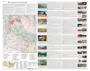
Arizona's Natural Regions


Arizona has two main natural regions. These are the Colorado Plateau and the Basin and Range Province. There is also a special area between them called the Transition Zone.
The Colorado Plateau
The Colorado Plateau is a mostly flat area that is semi-dry. Its height ranges from 5,000 to 8,000 feet (1,524 to 2,438 meters) above sea level. It is centered around the Four Corners region. This plateau covers about 140,000 square miles (360,000 square kilometers). It includes northern Arizona, except for a small part in the northwest. The plateau ends with the steep rock wall of the Mogollon Rim. This rim marks the southern edge of the plateau.
The Colorado Plateau is often called "Red Rock Country." This is because of its bright, colorful sedimentary rocks. These rocks are visible due to the dry climate and erosion. The amazing canyons of the Colorado River show off the geology of this area. The Grand Canyon reveals some of the most unique rock layers in the world. This region has many special natural features. These include the Grand Canyon, Antelope Canyon, Meteor Crater, Painted Desert, and the Petrified Forest.
The Transition Zone
The Transition Zone is a mountainous area in central Arizona. It runs from northwest to southeast. It's where the higher Colorado Plateau meets the lower Basin and Range Province. It's called the Transition Zone because it shares features from both regions. This area has many rugged mountain ranges and valleys. Many of these mountains are part of the Mogollon Rim. This is a dramatic cliff that stretches about 115 miles (185 km). It goes from northern Yavapai County towards the New Mexico border.
Mountain ranges in the Transition Zone include the Mazatzal, Santa Maria, Sierra Ancha, and White ranges. Because the elevation changes a lot here, the weather can be very different over short distances. The Transition Zone often gets more rain because of its mountains. Temperatures also change with altitude.
The Basin and Range Province
The Basin and Range Province covers the southern part of Arizona. It also includes a strip of land in the western part of the state. This region is part of a much larger area. It extends into New Mexico, Utah, Nevada, and northwestern Mexico. The Basin and Range is known for its steep, long mountain ranges. These mountains are separated by wide deserts. The mountain ranges can rise over 9,000 feet (2,700 meters) above the desert plains. They create "biological islands" where cool-climate plants and animals live.
The geology of this area is due to the Earth's crust stretching. This stretching has made the crust under this region very thin. The Basin and Range provides almost all the copper mined in Arizona. It also has other valuable minerals like gold, silver, and barite.
Arizona's Rivers
The main rivers in Arizona are the Colorado River and its major branch, the Gila River. Almost all of Arizona's land is drained by either the Colorado River or one of its branches.
The Colorado River
The Colorado River is very important to Arizona because the region is always dry. The river is famous for creating the Grand Canyon over six million years. Several irrigation systems take water from the Colorado River. The most important one for Arizona is the Central Arizona Project. This project is 336 miles (541 km) long. It moves 1,500,000 acre-feet (1.85 cubic kilometers) of water from Lake Havasu City to central and southern Arizona. The river is also used to make electricity using dams. The dams on the Colorado River, going downstream, are the Glen Canyon Dam, Hoover Dam, Davis Dam, Parker Dam, Imperial Dam, Laguna Dam, and the Morelos Dam.

The Gila River
The Gila River is 650 miles (1,050 km) long. It flows from southwestern New Mexico to where it meets the Colorado River near Yuma. The upper part of the Gila River flows freely. However, the part of the river below the Phoenix area is usually just a trickle or completely dry. This is because its water is used for irrigation. The only major dam on the Gila River is Coolidge Dam. It is located 31 miles (50 km) southeast of Globe, Arizona.
Arizona's Deserts

The Sonoran Desert
The Sonoran Desert covers the southwestern area of Arizona. This includes the cities of Phoenix, Tucson, and Yuma. The Sonoran Desert is one of the hottest deserts in the United States. It stays warm all year round. Even with little rain, this desert has many different plants and animals. This is because it has two rainy seasons each year. Many plants thrive here because they have special ways to adapt to the climate. You can find various types of cactus growing wild. The Sonoran Desert is the only place in the world where the saguaro cactus grows naturally. The fishhook, prickly pear, and organ pipe are other types of cactus found here.
The Mojave Desert
Northwestern Arizona contains part of the Mojave Desert. This desert is at a higher altitude than the Sonoran Desert. You can tell where the Mojave Desert begins by finding the Yucca brevifolia (Yucca palm). This plant grows only in this desert. Unlike the Sonoran Desert, the Mojave Desert has fewer trees and less variety of tree species.
The Painted Desert
The Painted Desert is a large area of badlands in Northern Arizona. It is located on the Colorado Plateau. It covers at least 146 square miles (378 square kilometers). It stretches from about 30 miles (48 km) north of Cameron, near the Grand Canyon. It ends just past the Petrified Forest. The Painted Desert gets its name from the many colored sediments and clay visible there. These come from its Chinle rock formation, exposed by erosion. In the southern part of the desert, you can find fossilized remains of a Triassic period coniferous forest. These have turned to stone over millions of years. Most of the Painted Desert is within the Navajo Nation and can only be reached by walking.
The Chihuahuan Desert
A small part of southeastern Arizona is within the Chihuahuan Desert. Because it is at a higher elevation than the Sonoran Desert, it usually has milder temperatures during the summer.
Arizona's Islands
Arizona is the third largest state without an ocean coastline. Only Montana and New Mexico are larger. Even though it's landlocked, Arizona does have islands. The state has the third lowest amount of water, only 363.73 square miles (942 square kilometers). Arizona's 0.3% water area is the second lowest percentage after New Mexico's 0.2%. Most of Arizona's islands are in the Colorado River, especially in Lake Mead. Lake Roosevelt also has several islands.
Arizona's Mountains

Arizona is a fairly mountainous state with rugged terrain. It is home to the world's largest continuous ponderosa pine forest. Many mountain ranges are over 9,000 feet (2,700 meters) high. Some of these can keep snow all summer long.
Arizona has 194 named mountain ranges. The highest ones are along the southwest edge of the Colorado Plateau. These include the volcanic San Francisco Peaks just north of Flagstaff and the White Mountains of the Mogollon Rim. The Basin and Range region in southern and western Arizona has many rugged ranges. These appear as "sky islands" in the Sonoran and Chihuahuan deserts.
Arizona's Ten Highest Mountain Peaks
Humphreys Peak
Humphreys Peak is the highest point in Arizona. It is located in the Coconino National Forest. It is part of the San Francisco Peaks, a volcanic mountain range 9 miles (14 km) north of Flagstaff. It reaches 12,633 feet (3,851 meters) above sea level. It is one of the most prominent peaks in the United States outside the Rocky Mountains. The mountain is high enough to keep snow cover in summer. Temperatures there may not go above 40°F (4°C) even then. The only maintained path to the top is the Humphreys Trail. This is a challenging hike that starts at Arizona Snowbowl. Near the top, Humphreys Peak has the only area of subarctic tundra south of the Rocky Mountains.
Agassiz Peak
Simply called "Agassiz," Agassiz Peak is a sister peak to Mount Humphreys. It is one of the San Francisco Mountains' "Big 4," or the top five highest peaks in Arizona. Its summit is 12,356 feet (3,766 meters) above sea level. This mountain is closed to climbers in the summer. This helps protect its delicate tundra environment. This peak usually loses its snow by late May but has been known to keep snow until June.
Fremont Peak
At 11,946 feet (3,641 meters) above sea level, Fremont Peak is also in the San Francisco Mountains. This summit is not very well known to visitors or locals. It is located along the Doyle Saddle, where it doesn't stand out much. It is more of a high point on the Doyle Saddle than a distinct summit. The Humphreys Trail runs along this ridge and over Fremont Peak.
Aubineau Peak
Aubineau Peak is the fourth highest summit in Arizona. It reaches 11,818 feet (3,602 meters) above sea level. This is a fairly steep peak. It was the site of an avalanche in 2005. This mountain is on the north side of the San Francisco Mountains and is next to Abineau Canyon.
Ree's Peak
Ree's Peak is much smaller than most of the summits in the San Francisco mountains. At 11,444 feet (3,488 meters), it forms the northeastern tip of the range. This peak does not have alpine tundra. However, it is home to the famous bristlecone pine. The peak is only easy to spot if you look directly at it. Otherwise, the other summits make it hard to see.
Doyle Peak
Doyle Peak is listed at 11,440 feet (3,487 meters). You can see it as the peak furthest to the right when looking at the San Francisco Mountains from the Flagstaff area. The peak is best viewed from Shultz Pass road. It is known for its continuous aspen forest. This peak is the starting point of the Doyle Saddle, which connects Doyle Peak with Agassiz Peak.
Mount Baldy
Mount Baldy is in Arizona's White Mountains. It is located on the Fort Apache Indian Reservation. This is an eroded mountain peak whose summit is 11,391 feet (3,472 meters) above sea level. Locals gave it its name because it lacks trees on its upper ridge, making it look "bald." Mount Baldy is home to the Sunrise Ski Area. The mountain is a single prominent peak, not part of a range. Its sides are gentle, and its peak is rounded, not rugged. This is true for most of the White Mountains. They are a geologically old range that was once as high as the Alaska Range. However, they have been worn down over millions of years. Mount Baldy has a bristlecone pine forest. Some people consider the White Mountains an extension of the Rocky Mountains. This is because they have similar average elevations, tree species, animals, and weather.
Mount Ord
At 11,348 feet (3,459 meters), Mount Ord is part of the White Mountains. It is located in Apache County on the Fort Apache Indian Reservation. Snow often stays on this mountain the longest during summer. This is due to its high elevation and gentle north slope. Snow can stick at 3 to 6 inches (7.6 to 15 cm), sometimes more, until June. Only then does it melt into patches.
Paradise Butte
At 11,148 feet (3,398 meters), Paradise Butte is found in the White Mountains. It is near Mount Baldy and Mount Ord, close to Sunrise Ski Park.
Mount Thomas
In Apache County, Mount Thomas reaches 11,121 feet (3,390 meters).
Gallery
-
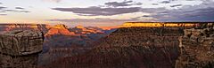
Grand Canyon South Rim at Sunset.
-
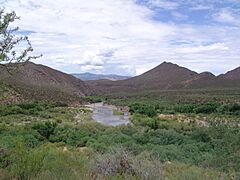
Upper Salt River (Arizona) with the Sierra Ancha in the background.
-
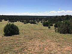
Pinyon-juniper woodland near Heber-Overgaard, Arizona.
-
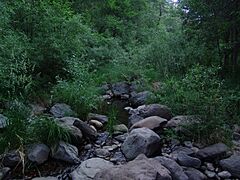
Riparian forest along upper Oak Creek Canyon


.jpg)

See also
- List of regions of Arizona
- List of volcanic craters in Arizona
