Greenview No. 6 Precinct, Menard County, Illinois facts for kids
Quick facts for kids
Greenview No. 6 Precinct
|
|
|---|---|

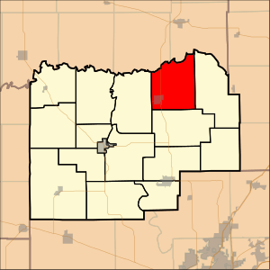
Location in Menard County
|
|
| Country | United States |
| State | Illinois |
| County | Menard |
| Area | |
| • Total | 22.74 sq mi (58.88 km2) |
| • Land | 22.63 sq mi (58.61 km2) |
| • Water | 0.11 sq mi (0.28 km2) 0.48% |
| Elevation | 515 ft (157 m) |
| Population
(2000)
|
|
| • Total | 1,038 |
| • Density | 45.9/sq mi (17.7/km2) |
| GNIS feature ID | 1928513 |
Greenview No. 6 Precinct is a special area in Menard County, Illinois, a state in the United States. It's like a small neighborhood or district. In the year 2000, about 1,038 people lived here.
Contents
What is a Precinct?
A precinct is a small area used for voting. When people vote, they go to a specific polling place in their precinct. This helps manage elections smoothly. Greenview No. 6 is one of these important voting areas.
Why Precincts Matter
Precincts make sure that everyone can vote easily. They help organize voters into smaller groups. This way, elections are fair and orderly for everyone.
Where is Greenview Precinct?
Greenview No. 6 Precinct is found in Menard County, which is in the central part of Illinois. Illinois is a large state in the Midwest region of the United States.
Location in Illinois
Menard County is known for its rich history. It is close to the state capital, Springfield. Greenview Precinct is part of this interesting area.
People of Greenview
According to the 2000 census, 1,038 people called Greenview No. 6 Precinct home. This number helps us understand the size of the community.
Population Details
The population density was about 17.7 people per square kilometer. This means that for every square kilometer, there were roughly 18 people living there.
Greenview's Geography
Greenview No. 6 Precinct covers an area of about 58.88 square kilometers (or 22.74 square miles). Most of this area is land, with a small amount of water.
Land and Water
About 58.61 square kilometers (22.63 square miles) of the precinct is land. The remaining 0.28 square kilometers (0.11 square miles) is water. This means it's mostly land, with a few small water features.
Elevation
The precinct is located at an elevation of about 157 meters (515 feet) above sea level. This tells us how high up the land is compared to the ocean.
See also
 In Spanish: Distrito electoral de Greenview n.º 6 para niños
 | John T. Biggers |
 | Thomas Blackshear |
 | Mark Bradford |
 | Beverly Buchanan |

