Guatapurí River facts for kids
Quick facts for kids Guatapurí River |
|
|---|---|

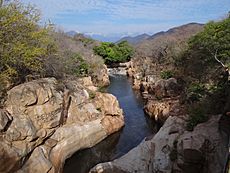
Guatapurí River in the outskirts of Valledupar
|
|
| Country | Colombia |
| Physical characteristics | |
| Main source | Curiba Lake 4,400 m (14,400 ft) |
| River mouth | Cesar River |
| Length | 80 km (50 mi) |
The Guatapurí River is a beautiful river in northern Colombia. In Spanish, it's called Río Guatapurí. It flows from the eastern side of the Sierra Nevada de Santa Marta mountains. This river joins the Cesar River near the city of Valledupar.
The name Guatapurí comes from the Chimila language. It means "cold water," which is perfect for this cool mountain river! Its main source is Curiba Lake, located very high up. This lake is about 4,400 metres (14,400 ft) above sea level. The Guatapurí River is approximately 80 kilometres (50 mi) long. Many smaller rivers join it, like the Donachui, Capitanejo, and Los Mangos rivers.
About the Guatapurí River
The Guatapurí River is an important part of the landscape in the Cesar Department of Colombia. It provides fresh water to the region. The river's journey starts high in the mountains. It then flows down towards the lower lands.
Where the River Flows
The river begins its journey in the high Sierra Nevada de Santa Marta. This is a very tall mountain range. The water from Curiba Lake feeds the river. As it flows, other small rivers add their water to it. Finally, the Guatapurí River meets the Cesar River. This happens close to the city of Valledupar.
The River's Importance
The Guatapurí River is very important for the people living nearby. It is a source of water for drinking and farming. It also offers a place for people to relax and enjoy nature. The river is a natural landmark for the city of Valledupar.
See also
 In Spanish: Río Guatapurí para niños
 | Chris Smalls |
 | Fred Hampton |
 | Ralph Abernathy |

