Cesar River facts for kids
Quick facts for kids Cesar River |
|
|---|---|

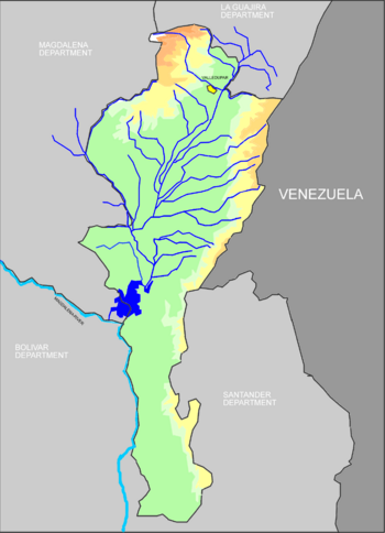
The Cesar River basin, Cesar Department in color
|
|
| Country | Colombia |
| Physical characteristics | |
| Main source | Colombia |
| River mouth | Magdalena River |
The Cesar River (called Río Cesar in Spanish) is an important river in northern Colombia. It's part of the larger Magdalena River system. This river flows through a special area called the Cesar-Ranchería Basin. It acts like a natural border, separating the tall Sierra Nevada de Santa Marta mountains from the Serranía del Perijá mountain range. The Serranía del Perijá is actually a part of the big Eastern Mountain Range of Colombia.
The Cesar River starts high up in the Sierra Nevada de Santa Marta mountains, in the Guajira Department. It then flows south into the Cesar Department. Eventually, it reaches the Zapatosa Marsh, a large wetland. From there, it turns southwest and empties its waters into the mighty Magdalena River. The city of Valledupar is the main city located along the Cesar River's path.
What Rivers Join the Cesar?
A tributary is a smaller river or stream that flows into a larger river. The Cesar River gets water from several tributaries, including:
- Badillo River
- Guatapuri River
- Ariguani River
- Villanueva River, which is about 43 kilometers (27 miles) long and comes from the Cerro Pintao area.
The Cesar River also connects with many streams and wetlands around the Zapatosa Marshes, such as:
- Bartolazo wetlands
- Pancuiche wetlands
- Pancuichito wetlands
- La Palma wetlands
- Santo Domingo wetlands
- Tiojuancho wetlands
See also
 In Spanish: Río Cesar para niños
 | Audre Lorde |
 | John Berry Meachum |
 | Ferdinand Lee Barnett |

