
La Guajira Department facts for kids
Quick facts for kids
La Guajira Department
|
|||
|---|---|---|---|
|
|||
| Anthem: Himno de La Guajira. | |||
.svg)
La Guajira shown in red
|
|||

Topography of the department
|
|||
| Country | |||
| Region | Caribbean Region | ||
| Established | July 1, 1965 | ||
| Capital | Riohacha | ||
| Area | |||
| • Total | 20,848 km2 (8,049 sq mi) | ||
| Area rank | 25th | ||
| Population
(2018)
|
|||
| • Total | 880,560 | ||
| • Rank | 20th | ||
| • Density | 42.2371/km2 (109.394/sq mi) | ||
| Time zone | UTC-05 | ||
| ISO 3166 code | CO-LAG | ||
| Municipalities | 15 | ||
| HDI (2019) | 0.695 medium · 31st of 33 |
||
| Website | www.laguajira.gov.co/ | ||


La Guajira is a department in Colombia. It covers most of the Guajira Peninsula in the country's northeast. This area is located on the Caribbean Sea and shares a border with Venezuela. It is the northernmost tip of South America. The main city and capital of the department is Riohacha.
Many different indigenous tribes lived in this dry region long before Europeans arrived. In 1498, Alonso de Ojeda sailed around the peninsula. The first European to actually land in La Guajira was the Spanish explorer Juan de la Cosa in 1499. During the time of Spanish rule, the land of La Guajira was often fought over. This was because it had valuable pearl deposits. Even English pirates, Frenchmen, and Germans tried to take control of the area.
Martin Fernandez de Enciso started the first colonial village here, called Nuestra Señora Santa María de los Remedios del Cabo de la Vela. In 1535, Nikolaus Federmann moved and renamed the settlement to Riohacha. This happened because of constant attacks from the Wayuu people. In 1544, the town was moved again to where the city is today. In 1871, La Guajira became its own national territory, separate from the Department of Magdalena. It was made an Intendance in 1898.
In 1911, the Colombian government created the Commissary of La Guajira. In the 1930s, many immigrants arrived from the Middle East. These included Christian Arabs, Maronites, and Shi'i Muslims from Lebanon, Syria, Palestine, and Jordan. They mostly settled in the city of Maicao. In 1954, La Guajira was again made an Intendance, and Riohacha became a municipality. Finally, in 1964, the Department of La Guajira was officially created.
The department's economy relies on money from coal mining at Cerrejón. It also depends on natural gas and salt mines. A popular place for ecotourism is Cabo de la Vela. This is a small fishing village in the Guajira desert.
Contents
Understanding the Name: Etymology
The name Guajira comes from the Cariban languages. The word Guajiros was first used around the year 1600. It described about 200 indigenous families living near Riohacha. These families were known for having many goats. The Spanish then used this term for all indigenous people on the peninsula who herded goats. Some records show the term Guajiro first appeared in 1626.
Exploring the Land: Geography

The northern part of La Guajira has dry plains called the Guajira-Barranquilla xeric scrub. These areas are dry because the Sierra Nevada de Santa Marta mountains block the rain. These mountains reach 5,775 metres (18,947 ft) high in the south. The Sinú Valley dry forests are located between these areas. In the far south, the Cesar River begins and flows south towards the Magdalena River.
The Ranchería River also starts in the Sierra Nevada de Santa Marta. It flows from south to north across the Guajira Peninsula and into the Caribbean Sea. The Serranía del Perijá and the Montes de Oca mountains are in the southeast, along the border with Venezuela.
The department is divided into three main areas based on their geography: Upper, Middle, and Southern Guajira.
- Upper Guajira is the northernmost part of the peninsula. It has mostly dry, desert-like plants. It also has a small mountain range called the Serranía de Macuira, which is 865 meters above sea level.
- Middle Guajira is mostly flat with some hills. It is also a dry area.
- Southern Guajira includes the Montes de Oca and Serranía del Perijá mountain ranges, which border Venezuela. It also has a valley formed by the Sierra Nevada de Santa Marta mountains. Southern Guajira has more green plants, wetlands, and rivers.
Natural Areas: Ecoregions
La Guajira is part of the Colombian Caribbean region. This is one of the five natural regions of Colombia.
Serranía de Macuira

The Serranía de Macuira mountains are in the northwest of the Guajira Peninsula. They cover about 35,000 hectares (86,000 acres), with 25,000 ha (62,000 acres) inside the Macuira National Park. This mountain range is like an isolated island of life in the middle of the La Guajira Desert. It acts as a barrier, catching humid winds from the northeast.
Sierra Nevada de Santa Marta
The Sierra Nevada de Santa Marta mountain range is on the Caribbean Sea. It is shared with the departments of Magdalena and Cesar. Most of La Guajira's water comes from this mountain range. This includes the Ranchería River, which flows through most of the department. UNESCO has declared the Sierra Nevada de Santa Marta a Biosphere Reserve.
Cerro Pintao
The Cerro Pintao (meaning "Painted Hill") is a mountain that gives rise to about 13 rivers in Colombia. It covers an area of 25,000 hectares (62,000 acres). Its altitudes range from 1,600 to 3,688 metres (5,249 to 12,100 ft). It forms a Páramo ecosystem, which is a unique high-altitude grassland.
Flamingos Fauna and Flora Sanctuary
The Santuario de Flora y Fauna los Flamencos (Flamingos Fauna and Flora Sanctuary) is on the coast near Riohacha. It covers 7,000 hectares (17,000 acres). The sanctuary has four lagoons and many streams. These provide a home for flamingos and many other unique animals and plants.
Flamingos Protection Area
This area is in the village of Musichi, within the municipality of Manaure. It has many lagoons that local people use to make salt by hand.
Weather Patterns: Climate
| Climate data for Riohacha | |||||||||||||
|---|---|---|---|---|---|---|---|---|---|---|---|---|---|
| Month | Jan | Feb | Mar | Apr | May | Jun | Jul | Aug | Sep | Oct | Nov | Dec | Year |
| Record high °C (°F) | 39.2 (102.6) |
36.7 (98.1) |
39.8 (103.6) |
38.4 (101.1) |
38.0 (100.4) |
38.6 (101.5) |
38.1 (100.6) |
38.8 (101.8) |
39.4 (102.9) |
36.6 (97.9) |
35.8 (96.4) |
38.6 (101.5) |
39.8 (103.6) |
| Mean daily maximum °C (°F) | 32.4 (90.3) |
32.5 (90.5) |
32.5 (90.5) |
32.6 (90.7) |
33.2 (91.8) |
34.2 (93.6) |
34.8 (94.6) |
34.8 (94.6) |
33.4 (92.1) |
32.4 (90.3) |
32.1 (89.8) |
32.3 (90.1) |
33.1 (91.6) |
| Mean daily minimum °C (°F) | 21.8 (71.2) |
21.9 (71.4) |
22.9 (73.2) |
24.2 (75.6) |
24.8 (76.6) |
25.3 (77.5) |
25.2 (77.4) |
25.0 (77.0) |
24.4 (75.9) |
23.7 (74.7) |
23.3 (73.9) |
22.5 (72.5) |
23.8 (74.7) |
| Record low °C (°F) | 17.2 (63.0) |
17.0 (62.6) |
17.0 (62.6) |
17.2 (63.0) |
20.8 (69.4) |
20.0 (68.0) |
17.2 (63.0) |
19.8 (67.6) |
19.2 (66.6) |
20.0 (68.0) |
18.8 (65.8) |
16.8 (62.2) |
16.8 (62.2) |
| Average rainfall mm (inches) | 0.5 (0.02) |
0.8 (0.03) |
2.6 (0.10) |
25.8 (1.02) |
75.5 (2.97) |
37.1 (1.46) |
16.2 (0.64) |
52.3 (2.06) |
115.9 (4.56) |
142.8 (5.62) |
59.2 (2.33) |
17.3 (0.68) |
546 (21.49) |
| Average rainy days | 1 | 1 | 1 | 3 | 7 | 3 | 2 | 5 | 9 | 10 | 5 | 2 | 49 |
| Average relative humidity (%) | 70 | 70 | 71 | 74 | 75 | 68 | 66 | 71 | 76 | 79 | 79 | 74 | 73 |
| Mean monthly sunshine hours | 259.3 | 229.8 | 235.4 | 195.0 | 193.5 | 230.3 | 249.4 | 236.5 | 198.1 | 211.7 | 217.5 | 238.2 | 2,694.7 |
| Source: INSTITUTO DE HIDROLOGIA METEOROLOGIA Y ESTUDIOS AMBIENTALES | |||||||||||||
A Look Back: History
Ancient Times: Pre-Columbian Era

Before Christopher Columbus arrived, La Guajira was mainly home to indigenous tribes. In the dry northern lowlands, groups like the Wayuu and Cocina lived. In the south, you would find the Kogui, Arhuaco, Guanebucan, and Chimila peoples. Archeologists have found signs of fishing communities using pottery from as far back as 10th century BC.
These groups lived together on the Guajira Peninsula. The northern indigenous peoples were nomads. They traveled the peninsula, hunting, fishing, and gathering fruits. The southern groups were semi-settled. They farmed and used resources from the coast.
Spanish Arrival and Rule

In 1498, Spanish explorers led by Alonso de Ojeda first saw the Guajira Peninsula. They sailed along the coast but did not land. In 1502, a Spanish expedition led by Juan de la Cosa was the first to step ashore at Cabo de la Vela.
In 1524, Rodrigo de Bastidas created the government of Santa Marta. This area stretched from Cabo de la Vela to the mouth of the Magdalena River.
In 1535, Martín Fernández de Enciso founded the first Spanish settlement in La Guajira. It was a village near present-day Cabo de la Vela, named Nuestra Señora Santa María de los Remedios del Cabo de la Vela. In 1544, the village was moved to present-day Riohacha. This was because of constant attacks from indigenous people and from other Spanish groups. Nikolaus Federmann refounded the town.
Between 1609 and 1640, the Spanish brought over 800 African slaves. Many of these slaves later escaped and formed their own free communities called palenques. In 1679, the government of Santa Marta offered these communities freedom. In return, they had to help protect the area from English pirates and the Venezuelan government, who wanted the Guajira Peninsula for its pearls.
La Guajira was a unique territory in Colombia. It remained isolated for a long time during the Spanish colonization of the Americas. This was due to the strong resistance of the indigenous peoples, especially the Wayuu. It wasn't until the 18th century that the Spanish monarchy ordered a full conquest of the region. Conflicts between the colonizers and indigenous groups continued throughout the 19th century.
The Guajira Rebellion

The Wayuu people were never fully controlled by the Spanish. The two groups were almost always at war. There were many rebellions. For example, in 1701, the Wayuu destroyed a mission. In 1727, over 2,000 indigenous people attacked the Spanish. Other uprisings happened in 1741, 1757, 1761, and 1768. In 1718, Governor Soto de Herrera called the Wayuu "barbarians" and "worthy of death." The Wayuu were unique among Colombian indigenous groups because they learned to use firearms and horses.
.jpg)
In 1769, the Spanish captured 22 Wayuu people. They planned to make them work on building forts in Cartagena. The Wayuu's reaction was unexpected. On May 2, 1769, at El Rincón, near Río de la Hacha, they set the village on fire. They burned the church and two Spaniards who were hiding inside. They also captured the priest. The Spanish quickly sent a force to capture the Wayuu. This force was led by José Antonio de Sierra, a mixed-race man who had captured the 22 Wayuu earlier. The Wayuu recognized him and forced his group to hide in a house, which they then set on fire. Sierra and eight of his men were killed.
News of this success spread quickly to other Wayuu areas. More men joined the revolt. At its peak, there were an estimated 20,000 Wayuu fighters. Many had firearms they got from English and Dutch traders, and sometimes even from the Spanish. These weapons helped the rebels capture and burn almost all the settlements in the region. Authorities reported that over 100 Spaniards were killed, and many others were taken prisoner. The rebels also took many cattle. The Wayuu rebels were not completely united themselves. Sierra's relatives among the Wayuu fought against the rebels to get revenge for his death. This, along with the arrival of Spanish reinforcements, helped calm the rebellion. However, the Wayuu had already taken back much of their land.
Modern Era: Republican Period
In 1846, the new government of the Republic of New Granada created the "Guajiro territory." This was part of the State of Magdalena. However, the indigenous people were involved in a lot of illegal trade. Problems with the authorities continued, and the territory was again put under the government of Santa Marta.
In 1871, La Guajira was again given its own separate administration and became a national territory. It became an intendencia in 1898 and a commissary in 1911. In 1954, it was changed back to an intendencia. Finally, in 1964, the Department of La Guajira was officially created.
Spreading the Faith: Evangelization of Indigenous Peoples

The effort to teach the Christian faith to the Wayuu people began again in 1887. This was led by Capuchin friars. In 1905, Pope Pius X created the Vicariate of La Guajira. The first vicar, Friar Atanasio Vicente Soler y Royo, tried to "civilize" the Wayuu people.

In 1903, the Capuchin Friars started building orphanages for Wayuu children. The first was the La Sierrita Orphanage in the Sierra Nevada de Santa Marta mountains. The San Antonio Orphanage was built in 1910, and the Nazareth Orphanage in 1913. These orphanages influenced many Wayuu communities. The friars often visited settlements, inviting people to church. Wayuu children in the orphanages learned European customs. Conflicts between the Wayuu people and the Colombian government have become less frequent since then. In 1942, Uribia celebrated Christmas and New Year's Eve for the first time.
How La Guajira is Governed: Politics
The Department of La Guajira is governed by local versions of Colombia's three government branches.
- The executive branch is led by the Governor of the Department of La Guajira. The governor is elected every four years by popular vote.
- The legislative branch is the Department Assembly of La Guajira.
- The judicial branch includes regional courts under the Superior Tribunal of Riohacha. Its members are chosen by the Supreme Court of Colombia.
Control institutions also have local representatives. These institutions oversee the 15 municipalities. Each municipality is run by an elected mayor, a town council, and local courts.
Local Divisions: Administrative Divisions
The Department of La Guajira is made up of 15 municipalities. Each one has an elected mayor and a city council, plus local courts. Twelve of these municipalities are part of a special government program for border areas. These include San Juan del Cesar, La Jagua del Pilar, Barrancas, El Molino, Fonseca, Hatonuevo, Maicao, Uribia, Urumita, Villanueva, Manaure, and Riohacha. The municipalities of Dibulla, Albania, and Distracción are not part of this program. La Guajira also has 126 corregimientos (local magistrate areas), 49 inspecciones de policía (police districts), and 10 caseríos (villages).
List of Municipalities

 Albania
 Barrancas
 Dibulla
 Distracción
 El Molino
 Fonseca
 Hatonuevo
 La Jagua del Pilar
 Maicao
 Manaure
 Riohacha
 San Juan del Cesar
 Uribia
 Urumita
 Villanueva
Keeping the Peace: Defense
The Colombian National Police has a regional command center in La Guajira. It is usually led by a colonel and based in Riohacha. The Colombian National Army has two units in the department. Both are part of the 1st Division. These are the 2nd Mechanized Cavalry Battalion in Distracción and the 6th Mechanized Battalion in Riohacha. The Colombian Air Force serves La Guajira from its base in Barranquilla, Atlántico. They use the Almirante Padilla Airport as their airstrip.
Who Lives Here: Demographics

| Historical population | ||
|---|---|---|
| Year | Pop. | ±% |
| 1973 | 181,771 | — |
| 1985 | 299,995 | +65.0% |
| 1993 | 433,361 | +44.5% |
| 2005 | 681,575 | +57.3% |
| 2018 | 880,560 | +29.2% |
| Source: | ||
According to the DANE (Colombia's statistics office) 2005 Census, 44.9% of La Guajira's population was indigenous. Most of these belonged to the Arhuaco, Koguis, Wiwa, and Wayuu tribes. About 7.5% of the population was of Afro-Colombian descent. The remaining 47.6% did not identify with a specific ethnic group, except for people of Middle Eastern descent who moved there in the 20th century.
La Guajira had the largest indigenous population of any Colombian department. The municipalities with the most indigenous people were Uribia (95.9%), Manaure (88.2%), and Maicao (40.1%).
The total population of 623,250 made up 1.5% of Colombia's total population. It was also 7% of the Caribbean Region of Colombia's population. La Guajira had about 29.9 people per square kilometer. Of the total inhabitants, 50.6% were female and 49.4% were male.

| Municipality | Population | Percentage |
|---|---|---|
| Riohacha | 169,311 | 27.2% |
| Uribia | 116,674 | 18.7% |
| Maicao | 103,124 | 16.5% |
| Manaure | 68,578 | 11% |
| San Juan del Cesar | 25,587 | 4.1% |
| Fonseca | 22,220 | 3.6% |
| Barrancas | 22,207 | 3.6% |
| Dibulla | 21,098 | 3.4% |
| Albania | 20,898 | 3.4% |
| Villanueva | 18,804 | 3% |
| Hatonuevo | 9,797 | 1.6% |
| Urumita | 8,545 | 1.4% |
| Distraccion | 8,274 | 1.3% |
| El Molino | 5,937 | 1% |
| La Jagua del Pilar | 2,196 | 0.4% |
| TOTAL (2005) | 623,250 | 100% |
Learning and Growth: Education
The University of La Guajira has its main campus in Riohacha. It also has smaller campuses in Fonseca, Maicao, Manaure, Albania, and Villanueva. The university offers programs in science, engineering, economics, education, business, and humanities.
Making a Living: Economy


_2014-09-21_(3).jpg)
La Guajira's economy mainly relies on mining. This includes coal from the Cerrejón mines, natural gas, and salt from mines in Manaure. In 2005, these minerals made up 53.48% of all income.
The service industry is next, providing 11.06% of the total income. This includes electricity, gas, drinking water, transport, and communication. Education, health, community services, and home services make up 9.60%.
Farming, silviculture (growing trees), and fishing account for 7.99% of the total. Trade, hotels, and restaurants together make up 6.65% of the income. Public administration is 5.47%, construction is 3.01%, real estate is 2.21%, and industrial activities are 0.52%.
Farming and Crops: Agriculture
In 2005, La Guajira mainly grew tobacco, coffee, yuca, plantain, coconuts, ñame, arracacha, oil palm, and sugar cane. There were 1,211 temporary farms and 59,830 permanent farms.
People and Traditions: Culture
The culture in La Guajira is mostly shaped by the traditions of the Wayuu people. It is also influenced by European culture, especially Roman Catholic traditions, and by Afro-Colombian culture. Since the mid-20th century, Middle Eastern culture, including Islamic traditions, has also played a role. There is also a strong influence from Venezuela, as the traditional Wayuu land is shared by both countries.
How People Talk: Language
There are three main languages in La Guajira. The most common is Spanish language. The next most common is the Wayuu language. The growing number of Middle Eastern immigrants has also brought the Arabic language to the region. The Koguis and Wiwas speak their own dialects, which are related to Chibchan languages.
Spanish in La Guajira has also developed its own unique style, often using words from the Wayuu language. Wayuu and other indigenous groups receive education in both their native language and Spanish. Companies like Microsoft and Ubuntu have even created products in the Wayuu language.
There is also a small but important number of English speakers. They live in the Cerrejón mining community because of the bilingual school there.


| Group | Language | Population |
|---|---|---|
| Mestizo | Spanish | 300,000 |
| Wayuu | Wayuunaiki | 150,000 |
| Koguis | Koguian/Tezhuan | 7,100 |
| Wiwas | Dámana/Terruna shayama | 3,100 |
| Middle Eastern | Arabic | 3,061 |
| Ika | Ikan | 800 |
| Inga or Kingui | Ingan | 200 |
Sounds and Rhythms: Music
Music in La Guajira is connected to indigenous peoples, and also influenced by Afro-Colombian and European cultures. For example, vallenato music is thought to have started in the area between Riohacha and Valledupar. Some say it covers a larger area from Riohacha to central Cesar. The accordions and guitars used in vallenato music were supposedly brought into La Guajira illegally from the nearby island of Aruba.
The Wayuu people have their own traditional music and instruments. Their culture connects their economy and social life with music. For instance, they sing to their animals when raising cattle. They also use music for gatherings, celebrations, and even funerals. The Yonna is the traditional dance of the Wayuu. It is performed to welcome and honor guests.
The Wayuus created many simple musical instruments. These include the Kashi, Sawawa (a type of flute), ma'asi, totoy, and the taliraai (tubular flute), wootoroyoi (a type of clarinet), among others. The Majayura is a special ritual dance for young Wayuu women. A female dances towards a male she might marry, while other males play rhythms with their instruments, until the chosen male falls to the ground.
Delicious Dishes: Gastronomy
Food in La Guajira is linked to the traditional cooking of the indigenous Wayuu. It uses local animals and plants, and is also influenced by Spanish cuisine. The most famous dish from Guajira is friche. This is a fried or stewed goat dish seasoned with salt and its own blood and organs. Other dishes include Arroz con camarones (rice with shrimp), where the rice is cooked with shrimp that have been boiled and dried in the sun. There is also iguana stew with coconuts. Iguaraya is a fruit from the cactus that the Wayuus use to make juice or wine. You can also find turtles, deer, and capybaras cooked in different ways, often with rice, in soup, or as a stew.
Images for kids
-
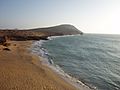
Cabo de la Vela was one of the first sites that Spanish explorers first sighted upon their arrival to the continental Americas.
-
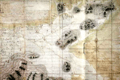
Map of La Guajira in 1769.
-
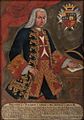
Pedro Messía de la Cerda, Viceroy of the Viceroyalty of New Granada.
-
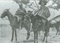
Wayuu riding on horses. 1928.
-
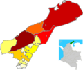
Map of La Guajira by population
-
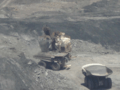
Trucks loaded with coal at the Cerrejón coal mine.
-
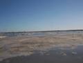
Manaure salt mine. Manaure provides approximately 80% of the Colombian market with salt.
-

Jepírachi wind farm in the Guajira Peninsula.
-
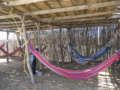
Typical Wayuu rectangular "day house" with hammocks by the Caribbean Sea. The Chinchorros hammocks are one of the most traditional items in the culture of La Guajira
-
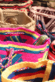
Wayuu handcrafted mochilas woolen bags have also transcended through cultures and fashion in Colombia.
See also
 In Spanish: La Guajira para niños
