
Urumita facts for kids
Quick facts for kids
Urumita
|
|||
|---|---|---|---|
|
Town
|
|||
|
|||
| Nickname(s):
"The Garden of La Guajira"
(Spanish: El Jardin de La Guajira) |
|||

Location of the town and municipality of Urumita in the Department of La Guajira.
|
|||
| Country | Colombia | ||
| Region | Caribbean | ||
| Department | La Guajira | ||
| Foundation | October 3, 1785 by Juan Bautista Canalete | ||
| Area | |||
| • Total | 329 km2 (127 sq mi) | ||
| Elevation | 255 m (837 ft) | ||
| Population
(Census 2018)
|
|||
| • Total | 10,198 | ||
| Time zone | UTC-5 | ||
| Climate | Aw | ||
| Website | urumita-guajira.gov.co/ |
||
| * | |||
.svg)

Urumita is a cool town and a municipality (which is like a local government area) in the La Guajira region of Colombia. It's often called "The Garden of La Guajira" because of its beautiful nature.
Contents
Exploring Urumita: Where is it?
Urumita is located in a special spot in Colombia. Part of it sits on the Serranía del Perijá mountain range. Another part stretches into the valley of the Cesar River.
The main town of Urumita is on a flat area. It's about 45 kilometers (28 miles) from Valledupar. This is the capital city of the Department of Cesar. It's also about 175 kilometers (109 miles) from Riohacha, the capital of La Guajira.
Urumita's Neighbors
Urumita shares its borders with several places. To the north, it borders Villanueva for about 36 kilometers (22 miles). To the south, it borders La Jagua del Pilar for about 50 kilometers (31 miles).
To the east, Urumita shares a 10-kilometer (6-mile) border with Venezuela. To the west, it borders Valledupar for about 15 kilometers (9 miles). The total area of Urumita is 329 square kilometers (127 square miles).
Urumita's Weather: Hot and Humid
The weather in Urumita is usually very warm or hot. The average temperature all year round is about 28°C (82°F). It doesn't change much throughout the year.
Urumita has a long rainy season. This lasts from April to November. There's a slightly drier time in the middle of the year. The shortest and driest season is from mid-December to March. Urumita's climate is known as a tropical savanna climate. This means it's warm all year with wet and dry seasons.
| Climate data for Urumita, elevation 255 m (837 ft), (1981–2010) | |||||||||||||
|---|---|---|---|---|---|---|---|---|---|---|---|---|---|
| Month | Jan | Feb | Mar | Apr | May | Jun | Jul | Aug | Sep | Oct | Nov | Dec | Year |
| Mean daily maximum °C (°F) | 33.6 (92.5) |
34.6 (94.3) |
34.9 (94.8) |
34.3 (93.7) |
33.1 (91.6) |
33.1 (91.6) |
34.1 (93.4) |
34.1 (93.4) |
33.0 (91.4) |
31.9 (89.4) |
31.7 (89.1) |
32.1 (89.8) |
33.4 (92.1) |
| Daily mean °C (°F) | 27.4 (81.3) |
28.0 (82.4) |
28.5 (83.3) |
28.4 (83.1) |
27.8 (82.0) |
27.9 (82.2) |
28.4 (83.1) |
28.3 (82.9) |
27.5 (81.5) |
27.0 (80.6) |
26.9 (80.4) |
26.8 (80.2) |
27.8 (82.0) |
| Mean daily minimum °C (°F) | 21.0 (69.8) |
21.4 (70.5) |
22.0 (71.6) |
22.8 (73.0) |
22.8 (73.0) |
22.7 (72.9) |
22.6 (72.7) |
22.7 (72.9) |
22.3 (72.1) |
22.0 (71.6) |
22.0 (71.6) |
21.5 (70.7) |
22.2 (72.0) |
| Average precipitation mm (inches) | 4.4 (0.17) |
13.1 (0.52) |
35.0 (1.38) |
111.3 (4.38) |
172.6 (6.80) |
123.5 (4.86) |
90.2 (3.55) |
112.8 (4.44) |
147.5 (5.81) |
187.3 (7.37) |
119.6 (4.71) |
47.7 (1.88) |
1,165 (45.9) |
| Average precipitation days | 1 | 1 | 3 | 8 | 15 | 13 | 10 | 15 | 16 | 17 | 10 | 3 | 113 |
| Average relative humidity (%) | 66 | 65 | 64 | 65 | 69 | 69 | 67 | 67 | 70 | 72 | 72 | 70 | 68 |
| Mean monthly sunshine hours | 266.6 | 231.5 | 226.3 | 174.0 | 170.5 | 174.0 | 207.7 | 195.3 | 162.0 | 176.7 | 192.0 | 229.4 | 2,406 |
| Mean daily sunshine hours | 8.6 | 8.2 | 7.3 | 5.8 | 5.5 | 5.8 | 6.7 | 6.3 | 5.4 | 5.7 | 6.4 | 7.4 | 6.6 |
| Source: Instituto de Hidrologia Meteorologia y Estudios Ambientales | |||||||||||||
Urumita's Past: A Look at its History
Before the Spanish arrived, the area where Urumita is now was home to the Chimila indigenous groups. In the early 1500s, when the Spanish came, a local leader called cacique Uruma governed the area.
After some time, on October 3, 1785, a person named Juan Bautista Canalete officially founded the village of Urumita. It became part of the larger area controlled by the municipality of Villanueva. This was all within the Government of Santa Marta. Later, it became part of the Province of Padilla.
Urumita slowly grew and gained more independence. In 1972, it became an "autonomous corregimiento." This means it had more control over its own local affairs. Then, in 1978, Urumita officially separated from Villanueva and became its own municipality. Its borders were confirmed again in 1982.
Urumita's Culture: The Calaguala Plant
Urumita has a special plant called Calaguala. This plant is very important to the local people. They believe it has medicinal properties and use it in many ways. It's a big part of their local traditions and beliefs.
To honor this special plant, the people of Urumita celebrate the Festival y Reinado de las Flores y la Calaguala. This festival is a big event where they celebrate flowers and the Calaguala plant. It's a time for fun, music, and showing off their culture.
Images for kids
-

The flag of Urumita.
-
The coat of arms of Urumita.
-
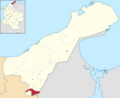
Map showing Urumita's location in La Guajira.
See also

- In Spanish: Urumita para niños
