Villanueva, La Guajira facts for kids
Quick facts for kids
Villanueva
|
|||
|---|---|---|---|
|
Municipality and town
|
|||
 |
|||
|
|||

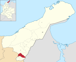
Location of the municipality and town of Villanueva in La Guajira Department.
|
|||
| Country | |||
| Region | Caribbean | ||
| Department | La Guajira | ||
| Foundation | January 16, 1662 by Roque de Alba | ||
| Area | |||
| • Municipality and town | 260.1 km2 (100.4 sq mi) | ||
| • Urban | 5.41 km2 (2.09 sq mi) | ||
| Elevation | 250 m (820 ft) | ||
| Population
(2018 census)
|
|||
| • Municipality and town | 28,346 | ||
| • Density | 108.981/km2 (282.26/sq mi) | ||
| • Urban | 26,488 | ||
| • Urban density | 4,896/km2 (12,681/sq mi) | ||
| Time zone | UTC-5 | ||
| Climate | Aw | ||
| Website | villanueva-guajira.gov.co | ||
Villanueva is a lively town and municipality in the northern part of La Guajira, Colombia. It's famous in Colombia for being the birthplace of many talented vallenato singers and composers. The town's economy mainly depends on farming and agriculture.
Contents
Geography of Villanueva
The municipality of Villanueva is located in the southern part of the Department of La Guajira. It sits in the valley of the Cesar River, nestled between two mountain ranges. These are the Sierra Nevada de Santa Marta and the Serranía del Perijá.
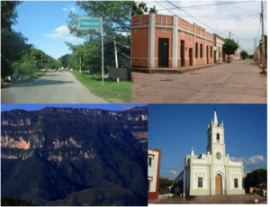
The Villanueva River flows through the municipality. This river eventually joins the Cesar River. The town itself is near a special hill called Cerro Pintao, which means "Painted Hill." This hill is also shared with other nearby towns.
Where Villanueva is Located
Villanueva shares its northern border with the municipality of El Molino. To the east, it borders the country of Bolivarian Republic of Venezuela. To the south, it is next to Urumita and San Juan del Cesar. To the west, it borders the Department of Cesar.
The total area of Villanueva is about 265 square kilometers. It is located about 250 meters above sea level. More than half of the municipality's land is part of the Serranía del Perijá mountains. The rest of the area is flat, forming part of the river valley.
Climate in Villanueva
The weather in Villanueva changes depending on how high up you are and how much rain falls. The average temperature in the municipality is around 28 degrees Celsius all year. Villanueva experiences two rainy seasons and two dry seasons throughout the year.
History of Villanueva
Before the Spanish explorers arrived in the early 1500s, the area of Villanueva was home to the Chimila people. A tribe called the Itotos lived here. Their leader was named cacique Canopan. Their village was known as Timiriguaco, which meant "great village." Don Roque de Alba is believed to have officially founded the village in 1662.
A Challenging Time
Like many places in Colombia, Villanueva faced a difficult period in its history. In the late 1990s, the town experienced some serious events. These events caused sadness and challenges for the community. The people of Villanueva have worked hard to overcome these past difficulties and build a peaceful future.
Economy of Villanueva
The main ways people earn money in Villanueva are through agriculture and trade. Farmers grow crops, and people buy and sell goods with other towns in Southern Guajira. They also trade with the city of Valledupar in the Department of Cesar.
Out of the total land, about 7,300 hectares are used for growing plants. Another 8,000 hectares are used for raising cattle. Some areas are not used, and about 454 hectares are covered by urban areas like homes and businesses. In the lower parts of the Serranía del Perijá mountains, there are deposits of limestone. People dig up this limestone using traditional methods.
Culture and Festivals
Villanueva is famous for its culture, especially its music. Every September, the town celebrates the Cradle of Accordions Festival. This is a big musical competition where vallenato artists show off their skills. It's also a religious celebration honoring Saint Thomas. This festival brings a lot of joy and visitors to the town.
See also
 In Spanish: Villanueva (La Guajira) para niños
 | Frances Mary Albrier |
 | Whitney Young |
 | Muhammad Ali |


