El Molino, La Guajira facts for kids
Quick facts for kids
El Molino
|
|||
|---|---|---|---|
|
town
|
|||
|
|||

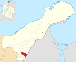
Location of the town and municipality of El Molino in the Department of La Guajira.
|
|||
| Country | Colombia | ||
| Region | Caribbean | ||
| Department | La Guajira | ||
| Foundation | 1595 | ||
| Area | |||
| • town | 190 km2 (70 sq mi) | ||
| • Urban | 1.5 km2 (0.6 sq mi) | ||
| Elevation | 240 m (790 ft) | ||
| Population
(2005)
|
|||
| • town | 5,937 | ||
| Time zone | UTC-5 | ||
| Climate | Aw | ||
| Website | elmolino-laguajira.gov.co/ |
||
| * | |||
El Molino (which means "The Mill" in English) is a small town and a municipality in Colombia. It is located in the La Guajira Department.
This town is famous for its old church, Ermita de San Lucas. This church is so important that it's considered a National Monument of Colombia. El Molino also hosts a fun event called the Festival del Cantante, which means "Festival of the Singer." The town became its own municipality in 1989.
Contents
Exploring El Molino's Geography
The municipality of El Molino is nestled in a valley. This valley is formed by two mountain ranges: the Sierra Nevada de Santa Marta and the Serranía del Perijá. The Cesar River also flows through this area.
El Molino is located on the lower slopes of the Serranía del Perijá mountains. It covers an area of 190 square kilometers and sits about 240 meters (787 feet) above sea level.
Where is El Molino Located?
You can find El Molino in the southern part of the La Guajira Department.
- To the west and north, it shares borders with the municipality of San Juan del Cesar.
- To the south, it borders the municipality of Villanueva.
- To the east, it is next to the country of Venezuela.
The El Molino River is very important for the town. It flows down from the Serranía del Perijá mountains and eventually joins the Cesar River, providing water for the area.
Understanding El Molino's Climate
The average temperature in El Molino throughout the year is around 28 degrees Celsius (82 degrees Fahrenheit). The region experiences two rainy seasons and two dry seasons each year.
The weather can change depending on how high up you are. It ranges from a dry, steppe-like climate to more mountainous conditions. Temperatures can vary between 16 degrees Celsius (61 degrees Fahrenheit) and 34 degrees Celsius (93 degrees Fahrenheit), offering warm, temperate, and sometimes colder weather.
A Glimpse into El Molino's History
The town of El Molino was first established in 1595. It was founded as "Villa del Rosario" by a Spanish colonizer named Pedro Beltrán Valdés. At that time, it was part of the Government of Santa Marta. Later, its name was changed to "Población de San Lucas de El Molino" and then simply to El Molino.
Who Lived Here First?
Before the Spanish arrived, the area was home to indigenous people from the Cariachiles group. Friars (religious brothers) from the Capuchin order gave the village the name "Población de San Lucas de El Molino." This name came from a Wheat mill that used to be there, but it was later taken down. Besides Spanish families, some people from Portugal, France, and Germany also settled in El Molino, though in smaller numbers.
Becoming a Municipality
For a while, El Molino was a smaller division (called a corregimiento) of the municipality of Villanueva. Then, in 1989, it officially became its own municipality. El Molino was formally separated from the municipality of San Juan del Cesar in 2001, after the people voted for it in a special referendum.
See also
 In Spanish: El Molino (La Guajira) para niños
 | Frances Mary Albrier |
 | Whitney Young |
 | Muhammad Ali |


