Fonseca, La Guajira facts for kids
Quick facts for kids
Fonseca
|
|||
|---|---|---|---|
|
Municipality and town
|
|||
|
|||
| Motto(s):
"Volver a ti es repetir la dicha de nacer"
|
|||

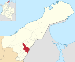
Location of the town and municipality of Fonseca in the Department of La Guajira.
|
|||
| Country | Colombia | ||
| Region | Caribbean | ||
| Department | La Guajira | ||
| Area | |||
| • Municipality and town | 473.5 km2 (182.8 sq mi) | ||
| • Urban | 5.46 km2 (2.11 sq mi) | ||
| Elevation | 11.8 m (38.7 ft) | ||
| Population
(2020 est.)
|
|||
| • Municipality and town | 44,544 | ||
| • Density | 94.074/km2 (243.650/sq mi) | ||
| • Urban | 39,662 | ||
| • Urban density | 7,264/km2 (18,814/sq mi) | ||
| Time zone | UTC-5 | ||
| Climate | Aw | ||
| Website | fonseca-guajira.gov.co/ |
||
| * | |||
Fonseca is a town and a municipality (like a county or district) in Colombia. It's located in the La Guajira Department, which is a region in Colombia. Fonseca is famous for its yearly celebration, the Festival del Retorno. This festival honors Saint Augustine with religious events and lively vallenato music.
Contents
Geography of Fonseca
The municipality of Fonseca covers an area of about 622 square kilometres or 240 square miles. The main town is located about 11 metres or 36 feet above sea level. Fonseca sits in a low area within the valley of the Ranchería River. This river flows through the municipality from west to east. The area is surrounded by two mountain ranges: the Sierra Nevada de Santa Marta and the Serranía del Perijá.
Fonseca shares its borders with several places. To the north, it borders the municipality of Riohacha and the Sierra Nevada de Santa Marta mountains. To the south, it borders the Bolivarian Republic of Venezuela and the Serranía del Perijá mountains. To the east, it borders the municipality of Barrancas. Finally, to the west, it has a narrow border with the municipality of San Juan del Cesar.
The average temperature in Fonseca throughout the year is about 28 °C or 82.4 °F. This temperature changes only a little, mostly due to how high up a place is in the mountains. The climate in the municipality varies. Some parts have a hot semi-arid climate, which means it's hot and dry. Other parts have a tropical savanna climate, which is also hot but gets more rain. There is a long rainy season from April to November, but the rain is not very heavy. The dry season is from December to March, with very little or no rain.
Climate in Fonseca
| Climate data for Fonseca (Paulina La), elevation 170 m (560 ft), (1981–2010) | |||||||||||||
|---|---|---|---|---|---|---|---|---|---|---|---|---|---|
| Month | Jan | Feb | Mar | Apr | May | Jun | Jul | Aug | Sep | Oct | Nov | Dec | Year |
| Mean daily maximum °C (°F) | 33.2 (91.8) |
34.1 (93.4) |
34.2 (93.6) |
34.2 (93.6) |
34.0 (93.2) |
34.9 (94.8) |
35.3 (95.5) |
35.0 (95.0) |
34.5 (94.1) |
33.8 (92.8) |
33.0 (91.4) |
32.4 (90.3) |
34.1 (93.4) |
| Daily mean °C (°F) | 27.3 (81.1) |
27.7 (81.9) |
28.1 (82.6) |
28.3 (82.9) |
28.1 (82.6) |
28.6 (83.5) |
29.0 (84.2) |
28.8 (83.8) |
28.0 (82.4) |
27.6 (81.7) |
27.1 (80.8) |
26.9 (80.4) |
28.1 (82.6) |
| Mean daily minimum °C (°F) | 22.1 (71.8) |
22.1 (71.8) |
22.4 (72.3) |
22.9 (73.2) |
23.5 (74.3) |
24.0 (75.2) |
24.0 (75.2) |
23.7 (74.7) |
23.1 (73.6) |
22.9 (73.2) |
23.0 (73.4) |
22.4 (72.3) |
23.0 (73.4) |
| Average precipitation mm (inches) | 7.4 (0.29) |
1.7 (0.07) |
11.0 (0.43) |
68.5 (2.70) |
93.9 (3.70) |
96.4 (3.80) |
70.2 (2.76) |
99.9 (3.93) |
138.2 (5.44) |
111.0 (4.37) |
87.1 (3.43) |
27.0 (1.06) |
812.2 (31.98) |
| Average precipitation days | 1 | 0 | 2 | 6 | 9 | 8 | 8 | 10 | 13 | 12 | 9 | 3 | 74 |
| Average relative humidity (%) | 70 | 69 | 69 | 70 | 75 | 73 | 70 | 73 | 77 | 80 | 78 | 78 | 73 |
| Mean monthly sunshine hours | 291.4 | 259.7 | 254.2 | 204.0 | 201.5 | 219.0 | 248.0 | 229.4 | 198.0 | 198.4 | 234.0 | 263.5 | 2,801.1 |
| Mean daily sunshine hours | 9.4 | 9.2 | 8.2 | 6.8 | 6.5 | 7.3 | 8.0 | 7.4 | 6.6 | 6.4 | 7.8 | 8.5 | 7.7 |
| Source: Instituto de Hidrologia Meteorologia y Estudios Ambientales | |||||||||||||
History of Fonseca
Long ago, the area where Fonseca is now was home to several different groups of native people. These included the Chimila, Tupe, Wayuu, Cariachile people, and Motilon.
There are two main ideas about how Fonseca was founded. One idea says that around the year 1750, a colonizer from Catalonia named Agustín Fonseca and an Italian named José Agustín Parodi started the village.
Agustín Fonseca led a group of explorers who settled near the Ranchería River. However, during a rainy season, the river flooded, causing illnesses. So, they moved to a drier spot. This new place is believed to be where Fonseca's main plaza is today. José Agustín Parodi was a captain working for the Spanish monarchy and arrived there by their orders.
In 1773, Fonseca was officially part of the Province of Santa Marta. Later, in 1967, the region of La Guajira became separate from the Magdalena Department. On June 13, 1829, Fonseca officially became a municipality of the Intendencia of La Guajira. This was made official by a special rule called Decree 1954. Finally, in 1954, Fonseca became a municipality within the Department of La Guajira.
Impact of Conflict in Fonseca
Since the 1970s, Fonseca has been affected by a period of internal conflict in Colombia. This is because of its important location. It lies between the Sierra Nevada de Santa Marta and Serranía del Perijá mountains, and it's also close to the border with Venezuela.
Different groups were active in the area. The Revolutionary Armed Forces of Colombia (FARC) and the National Liberation Army (ELN) were present. Later, a group called the United Self-Defense Forces of Colombia (AUC) appeared in the early 2000s. After being active in the area, the AUC group stopped its activities and officially disbanded in 2006.
Population of Fonseca
Demographics means studying the population of a place, like how many people live there and how that number changes. Here is information about the population of Fonseca from the year 2000 to 2004. The numbers show how many people lived in the town (urban) and in the surrounding countryside (rural).
| Year | Urban | Rural | Total |
|---|---|---|---|
| 2000 | 22,923 | 3,126 | 26,049 |
| 2001 | 23,702 | 3,232 | 26,934 |
| 2002 | 24,508 | 3,342 | 27,580 |
| 2003 | 25,341 | 3,456 | 28,797 |
| 2004 | 26,203 | 3,547 | 29,777 |
Culture and Traditions
Fonseca celebrates the Festival del Retorno every year. The name means "Festival of the Return." This special event celebrates people from Fonseca who have moved away to other towns, regions, or even countries. It's a time to welcome them back home and celebrate their return to the town.
See also
 In Spanish: Fonseca (La Guajira) para niños
 | Laphonza Butler |
 | Daisy Bates |
 | Elizabeth Piper Ensley |


