
Dibulla, La Guajira facts for kids
Quick facts for kids
Dibulla
|
|||
|---|---|---|---|
|
town
|
|||
|
|||
| Motto(s):
The ideal place for rebirth
|
|||

Location of the town and municipality of Dibulla in La Guajira Department.
|
|||

Dibulla, La Guajira
Location in Colombia
|
|||
| Country | |||
| Region | Caribbean | ||
| Department | La Guajira | ||
| Area | |||
| • Total | 1,847 km2 (713 sq mi) | ||
| Elevation | 2 m (7 ft) | ||
| Population
(2020 est.)
|
|||
| • Total | 39’069 | ||
| Time zone | UTC-5 | ||
| Climate | Aw | ||
.svg)

Dibulla (sometimes also called Dibuya) is a town and a special area (called a municipality) in Colombia. It is located in the La Guajira Department.
This town sits right by the Caribbean Sea and is close to the Sierra Nevada de Santa Marta mountains. It became its own municipality in 1995.
Dibulla is known as the hometown of Carlos Huertas. He was a famous vallenato composer. Vallenato is a popular type of folk music from Colombia. His song "El Cantor de Fonseca" is very well-known.
Contents
Geography of Dibulla
Dibulla is located in the northern part of Colombia. To its west is the Magdalena Department. To the north, it meets the Caribbean Sea at the base of the Sierra Nevada de Santa Marta mountains.
The town is about 74 kilometers away from Riohacha. Riohacha is the capital city of La Guajira. Dibulla is also crossed by two rivers: the Dibulla River and the Jérez River.
Size and Climate
The entire municipality of Dibulla covers an area of 1,847 square kilometers. It is very close to sea level, only about 2 meters high.
The average temperature in Dibulla is around 28 degrees Celsius. One of its main attractions is a fun beach spot called Maziruma. It's a great place for people to relax and enjoy the coast.
History of Dibulla
The area where Dibulla is today has a long history. Before Europeans arrived, it was home to indigenous groups. These included the Koguis and Guanebucanes tribes. They were descendants of the ancient Tairona civilization. The Wayuu people also had a strong influence here.
Early European Contact
In 1502, Spanish explorers first saw the indigenous village of Yaharo. This was when they reached the coasts of the Guajira Peninsula. Later, in 1525, a Spanish explorer named Rodrigo de Bastidas visited Yaharo. He wrote down what he saw about the village.
A year before, in 1524, Bastidas had set up the "Government of Santa Marta." This was a large area that stretched along the coast.
Changes Over Time
Between 1609 and 1640, many people from Africa were brought to the area. Many of them managed to escape and formed their own free communities. These communities were called Palenques.
In 1679, the government of Santa Marta made a deal with these Palenques. They offered them official freedom. In return, the Palenques would help protect the land from English pirates.
In 1846, the President of Colombia, Gen. Tomas Cipriano de Mosquera, made some changes. After a civil war, he ordered the government to be reorganized. The village of Yaharo was then renamed Dibuya. This new name means "lagoon by the sea" in the old Guanebucan language.
Becoming a Municipality
In 1872, Dibuya officially became a municipality or district. This was by a law passed that year. It was part of the Department of Magdalena at the time.
However, this status was removed in 1886. The area then became a "Corregimiento" of Riohacha. A Corregimiento is a smaller administrative area.
Finally, on December 5, 1995, Dibulla became its own municipality again. This was decided by the Assembly of La Guajira. Cristian Montero Córdoba was chosen as its first mayor.
Climate
| Climate data for Dibulla (Termoguajira), elevation 5 m (16 ft), (1981–2010) | |||||||||||||
|---|---|---|---|---|---|---|---|---|---|---|---|---|---|
| Month | Jan | Feb | Mar | Apr | May | Jun | Jul | Aug | Sep | Oct | Nov | Dec | Year |
| Mean daily maximum °C (°F) | 30.9 (87.6) |
30.8 (87.4) |
30.5 (86.9) |
30.9 (87.6) |
31.6 (88.9) |
32.4 (90.3) |
32.9 (91.2) |
32.6 (90.7) |
31.6 (88.9) |
31.1 (88.0) |
30.9 (87.6) |
30.6 (87.1) |
31.4 (88.5) |
| Daily mean °C (°F) | 26.1 (79.0) |
26.0 (78.8) |
26.1 (79.0) |
26.6 (79.9) |
27.0 (80.6) |
27.5 (81.5) |
27.8 (82.0) |
27.5 (81.5) |
26.8 (80.2) |
26.5 (79.7) |
26.3 (79.3) |
26.3 (79.3) |
26.7 (80.1) |
| Mean daily minimum °C (°F) | 19.4 (66.9) |
19.0 (66.2) |
19.8 (67.6) |
20.6 (69.1) |
21.2 (70.2) |
21.7 (71.1) |
21.6 (70.9) |
21.2 (70.2) |
21.1 (70.0) |
21.2 (70.2) |
21.4 (70.5) |
20.7 (69.3) |
20.9 (69.6) |
| Average precipitation mm (inches) | 28.9 (1.14) |
17.0 (0.67) |
34.3 (1.35) |
87.7 (3.45) |
135.0 (5.31) |
100.2 (3.94) |
59.6 (2.35) |
149.2 (5.87) |
227.6 (8.96) |
300.2 (11.82) |
256.7 (10.11) |
90.1 (3.55) |
1,437.3 (56.59) |
| Average precipitation days | 1 | 2 | 3 | 6 | 8 | 7 | 4 | 9 | 14 | 14 | 12 | 5 | 82 |
| Average relative humidity (%) | 84 | 83 | 83 | 83 | 84 | 83 | 82 | 82 | 84 | 85 | 85 | 85 | 84 |
| Mean monthly sunshine hours | 232.5 | 175.0 | 186.0 | 156.0 | 145.7 | 186.0 | 210.8 | 192.2 | 159.0 | 164.3 | 168.0 | 198.4 | 2,173.9 |
| Mean daily sunshine hours | 7.5 | 6.2 | 6.0 | 5.2 | 4.7 | 6.2 | 6.8 | 6.2 | 5.3 | 5.3 | 5.6 | 6.4 | 5.9 |
| Source: Instituto de Hidrologia Meteorologia y Estudios Ambientales | |||||||||||||
Images for kids
-
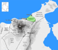
This map shows the Guanebucanes Province (in green) in the Government of Santa Marta, created in 1524.

See also
 In Spanish: Dibulla para niños
