Manaure, La Guajira facts for kids
Quick facts for kids
Manaure
|
|||
|---|---|---|---|
|
Town
|
|||

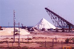
Salt mines in Manaure, La Guajira
|
|||
|
|||

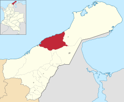
Location of the town and municipality of Manaure in the Department of La Guajira.
|
|||
| Country | |||
| Region | Caribbean | ||
| Department | La Guajira | ||
| Founded | 1723 | ||
| Area | |||
| • Total | 1,971 km2 (761 sq mi) | ||
| Elevation | 3 m (10 ft) | ||
| Population
(2019 est.)
|
|||
| • Total | 120,417 | ||
| • Density | 61.094/km2 (158.23/sq mi) | ||
| Demonym(s) | Manaurero | ||
| Time zone | UTC-5 | ||
| Area code(s) | 57 + 5 | ||
| Climate | BWh | ||
| Website | Official website: http://manaure-laguajira.gov.co/ | ||
| * | |||
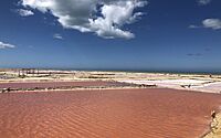
Manaure, also known as Salinas de Manaure, is a town and municipality in Colombia. It is located in the La Guajira Department. The most important activity in Manaure is collecting and processing salt. There are huge amounts of salt found here!
Contents
Where is Manaure?
Manaure is in the very north of South America. It sits on dry, flat lands called the Guajira Peninsula. This area is part of Colombia's Caribbean region. To the north, it touches the Caribbean Sea. To the east is Uribia, to the south is Maicao, and to the west is Riohacha.
Manaure is in a dry area with special plants and animals. This type of land is called a "xeric scrub." Water flows through the area only during the rainy seasons. The town of Manaure is crossed by the Limón Creek. This creek eventually flows into the Caribbean Sea. The coastline here has a lot of salt, rocks, and clay. The land is mostly flat, with some small hills.
Manaure's Climate
Manaure has a very hot and dry climate. It is known as a "hot arid climate" or desert climate. This is because a lot of water evaporates, even though it gets some rain. On average, Manaure receives about 375 millimeters (15 inches) of rain each year.
The weather is hot and dry all year long. Temperatures usually stay between 28°C (82°F) and 38°C (100°F). Strong winds blow from the northeast constantly. This means there is a lot of evaporation and humidity in the air.
Manaure has a main rainy season from August to November. About three-quarters of the yearly rain falls during these months. There is also a shorter period of light rains in May. Very little rain falls during the rest of the year.
| Climate data for Manaure, elevation 1 m (3.3 ft), (1981–2010) | |||||||||||||
|---|---|---|---|---|---|---|---|---|---|---|---|---|---|
| Month | Jan | Feb | Mar | Apr | May | Jun | Jul | Aug | Sep | Oct | Nov | Dec | Year |
| Mean daily maximum °C (°F) | 32.3 (90.1) |
32.4 (90.3) |
32.6 (90.7) |
32.7 (90.9) |
33.4 (92.1) |
34.6 (94.3) |
35.0 (95.0) |
34.7 (94.5) |
33.8 (92.8) |
33.0 (91.4) |
32.6 (90.7) |
32.5 (90.5) |
33.3 (91.9) |
| Daily mean °C (°F) | 28.1 (82.6) |
28.0 (82.4) |
28.1 (82.6) |
28.5 (83.3) |
29.1 (84.4) |
29.9 (85.8) |
30.1 (86.2) |
29.4 (84.9) |
29.2 (84.6) |
28.7 (83.7) |
28.7 (83.7) |
28.3 (82.9) |
28.8 (83.8) |
| Mean daily minimum °C (°F) | 23.9 (75.0) |
24.0 (75.2) |
24.4 (75.9) |
24.3 (75.7) |
24.7 (76.5) |
25.3 (77.5) |
25.0 (77.0) |
25.0 (77.0) |
25.1 (77.2) |
24.7 (76.5) |
24.4 (75.9) |
24.1 (75.4) |
24.6 (76.3) |
| Average precipitation mm (inches) | 3.7 (0.15) |
2.9 (0.11) |
6.1 (0.24) |
19.1 (0.75) |
39.9 (1.57) |
14.1 (0.56) |
11.4 (0.45) |
33.6 (1.32) |
58.4 (2.30) |
114.1 (4.49) |
68.1 (2.68) |
22.2 (0.87) |
382.2 (15.05) |
| Average precipitation days | 1 | 1 | 1 | 2 | 3 | 2 | 1 | 3 | 6 | 8 | 6 | 4 | 36 |
| Average relative humidity (%) | 74 | 74 | 75 | 74 | 73 | 69 | 67 | 71 | 73 | 76 | 74 | 75 | 73 |
| Mean monthly sunshine hours | 235.6 | 203.3 | 217.0 | 186.0 | 201.5 | 231.0 | 235.6 | 248.0 | 213.0 | 195.3 | 201.0 | 207.7 | 2,575 |
| Mean daily sunshine hours | 7.6 | 7.2 | 7.0 | 6.2 | 6.5 | 7.7 | 7.6 | 8.0 | 7.1 | 6.3 | 6.7 | 6.7 | 7.1 |
| Source: Instituto de Hidrologia Meteorologia y Estudios Ambientales | |||||||||||||
Manaure's Salt History
Long ago, Spanish explorers wrote about the Coanaos, an indigenous group. These people traveled between Cabo de la Vela and Valledupar. They traded salt for gold. In the 1800s, people started collecting salt from natural lagoons in Manaure. These lagoons were in Honda Bay and Quebrada Bay.
In 1777, the Spanish government decided to manage the salt mines. Then, in 1824, the Colombian government said the salt mines were a national treasure. They also set a price for the salt. Later, in 1932, the Bank of the Republic took over managing the salt mines. This included mines in Manaure, Zipaquirá, Nemocón, and Sesquilé.
Big-scale salt production in Manaure started in the 1920s. The government allowed private investors to collect salt. By the 1940s, salt collection changed from small-scale to industrial. This happened when the Bank of the Republic took control of the Manaure salt mines. By 1948, Manaure was producing between 20,000 and 30,000 tons of salt each year. In 1970, a company called IFI-Concesión Salinas took over. They increased production to one million tons a year!
The Wayuu People and Salt Mines
The Wayuu people, who are native to the area, began to say that Manaure was their ancestral land. They claimed they were the historical owners of the salt mines. In 1991, the government agreed with the Wayuu's claim. They decided to change how salt was produced and how people worked. This new plan was a "mixed economy." It meant the Wayuu people would own 25% of the salt company.
However, these agreements were not fully met. So, in 1994, the Wayuus sued the government. The court then ordered a new company to be created. It was called Sociedad Salinas de Manaure, SAMA. This company was based on the original agreement. The Wayuu were supposed to own 25% of it. But again, there were legal problems, and the agreements were not fully kept.
In 2002, a new law (Law 773) was passed. This law officially created SAMA again. It divided the company's earnings among three groups:
- The Ministry of Development (51%)
- The indigenous Association "Sumain Ichi" (25%)
- The municipality of Manaure (25%)
This new plan aimed to make sure the Wayuu people had a fair share in the salt production.
See also
 In Spanish: Manaure (La Guajira) para niños
 | James Van Der Zee |
 | Alma Thomas |
 | Ellis Wilson |
 | Margaret Taylor-Burroughs |


