Hınıs facts for kids
Quick facts for kids
Hınıs
|
|
|---|---|
|
Settlement
|
|
 |
|

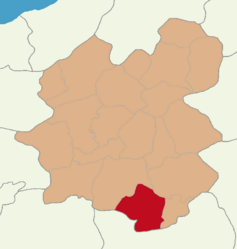
Map showing Hınıs District in Erzurum Province
|
|
| Country | Turkey |
| Province | Erzurum |
| Area | 1,367 km2 (528 sq mi) |
| Population
(2022)
|
24,680 |
| • Density | 18.054/km2 (46.760/sq mi) |
| Time zone | TRT (UTC+3) |
| Postal code |
25600
|
| Area code | 0442 |
Hınıs (which is pronounced Hee-nis) is a town and district in the Erzurum Province of Turkey. Its name comes from the Kurdish word Xinûs and the Armenian word Khnus. The district covers an area of 1,367 square kilometers (about 528 square miles). In 2022, about 24,680 people lived there.
Hınıs has some important historical buildings. These include an old castle and the Ulu Cami Mosque. People say the mosque was built in 1734 by Alaeddin, who was a leader from Muş. Most people living in Hınıs are Kurds.
The Hınıs district is about 150 kilometers (93 miles) from the city of Muş. It is also very close to Hamurpert Lake, which has a special place in history. Hınıs is surrounded by mountains. The Ak Dağ mountains are to the north. The Bingöl Mountains are to the west and south. The Akdoğan Mountains are to the south and east.
Hınıs shares borders with other districts. To the north are Tekman and Karayazı. To the east is Karaçoban. To the south are Varto, Bulanık, and Malazgirt, which are all in Muş Province. The town of Varto is only 40 kilometers (25 miles) away from Hınıs.
Hınıs is mostly a flat area, known as the Hınıs Plain. This plain is one of the most fertile areas in the region. Because of this, farming and raising animals are the main ways people earn money here. The weather in Hınıs is similar to Erzurum. Winters are very cold and snowy. Summers are usually cool. Hınıs is generally a bit warmer than Erzurum, by about 5-6 degrees Celsius (9-11 degrees Fahrenheit).
Contents
Geography of Hınıs
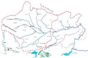
The Hınıs Plain is a high plain. It is located around a small river that flows into the Murat River. A line of hills to the south separates the Hınıs plain from the Murat River itself. The biggest river in Hınıs is Kocasu Creek. This creek flows through the center of the district. It then joins the Murat River in the Bulanık District.
To the southwest, hills and steep valleys separate the Hınıs plain from the Varto plain. To the north, there are pyramid-shaped hills called Ak Dağ, or White Mountains. These mountains connect to the Bingöl Mountains further west. This connection happens through a high flat area called Menge Dağ. The Menge Dağ forms the northwest edge of the Hınıs plain. From its base, you can see Mount Süphan in the distance.
The Hınıs plain has two main parts. Both parts are gently rolling and sometimes have small hills. The valley has very rich soil. For a long time, it has been a good place for raising sheep and horses.
The town of Hınıs itself is located near the upper part of this valley. It sits on a high area made of volcanic rock. More than 20 smaller streams come together here. They form the main river of the plain, the Kocasu Creek.
Climate and Weather
Hınıs has a climate called a dry-summer humid continental climate. This means it has very cold and snowy winters. Temperatures often stay below freezing. Summers are dry, with warm days and cool nights.
| Climate data for Hınıs (1991–2020) | |||||||||||||
|---|---|---|---|---|---|---|---|---|---|---|---|---|---|
| Month | Jan | Feb | Mar | Apr | May | Jun | Jul | Aug | Sep | Oct | Nov | Dec | Year |
| Mean daily maximum °C (°F) | −2.9 (26.8) |
−1.3 (29.7) |
4.2 (39.6) |
12.6 (54.7) |
18.6 (65.5) |
24.2 (75.6) |
29.2 (84.6) |
29.5 (85.1) |
24.6 (76.3) |
17.6 (63.7) |
8.3 (46.9) |
0.3 (32.5) |
13.8 (56.8) |
| Daily mean °C (°F) | −8.2 (17.2) |
−7.1 (19.2) |
−1.1 (30.0) |
6.4 (43.5) |
11.6 (52.9) |
16.6 (61.9) |
21.1 (70.0) |
21.1 (70.0) |
16.0 (60.8) |
9.8 (49.6) |
2.1 (35.8) |
−4.7 (23.5) |
7.0 (44.6) |
| Mean daily minimum °C (°F) | −13.1 (8.4) |
−12.3 (9.9) |
−5.8 (21.6) |
1.1 (34.0) |
5.1 (41.2) |
9.2 (48.6) |
13.5 (56.3) |
13.3 (55.9) |
8.1 (46.6) |
3.3 (37.9) |
−3.0 (26.6) |
−9.1 (15.6) |
0.9 (33.6) |
| Average precipitation mm (inches) | 46.7 (1.84) |
59.5 (2.34) |
71.39 (2.81) |
75.16 (2.96) |
67.15 (2.64) |
24.13 (0.95) |
14.28 (0.56) |
10.77 (0.42) |
14.95 (0.59) |
47.98 (1.89) |
47.76 (1.88) |
56.13 (2.21) |
535.9 (21.10) |
| Average precipitation days (≥ 1.0 mm) | 7.5 | 7.4 | 9.2 | 9.7 | 10.8 | 5.1 | 2.7 | 2.6 | 2.6 | 7.0 | 6.4 | 7.6 | 78.6 |
| Average relative humidity (%) | 78.6 | 77.7 | 73.8 | 65.1 | 61.3 | 52.0 | 44.8 | 43.6 | 48.9 | 61.6 | 69.0 | 77.8 | 62.9 |
| Source: NOAA | |||||||||||||
History of Hınıs
The Hınıs plain was once a big part of an old Armenian region. This was during the early Middle Ages (from about the 4th to the 7th centuries). Back then, Hınıs was likely a strong town with a market. It was a place where people traded goods and felt safe.
Later, after the Arabs took over Armenia, the area split into several smaller kingdoms. Hınıs was almost certainly the main city of one of these kingdoms. This kingdom was called Sermatz in Greek writings. Sermatz seemed to cover the old Hınıs region and the Varto plain. The rulers of Sermatz were probably under the control of the Kaysite leaders from Malazgirt.
During the time of the Kara Koyunlu (a group of Turkish tribes), Hınıs was the capital of a small Kurdish kingdom. This kingdom was connected to the emirate of Bitlis. The Bitlis emirate was itself connected to the Kara Koyunlu. The Hınıs kingdom was mainly on the Hınıs plain. But it also reached south of the Murat River to include Lake Nazik and the area around Bulanık. Later, under the Ottoman Empire, Hınıs became a sanjak (a type of administrative division) of Erzurum Eyalet.
Historical Buildings
Hınıs has two important historical buildings: a castle and a mosque.
Hınıs Castle
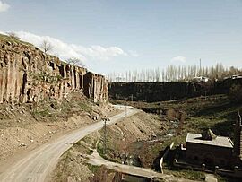
Hınıs's old castle sits on a small rocky hill. This hill sticks out from a dip in the middle of the flat area. You can only reach the castle rock from one side. This side has a raised "neck" of land that connects it to the rest of the plateau. This "neck" was where the walls that once surrounded the town began. Today, only a few towers of the castle are still standing.
Ulu Cami Mosque
The Ulu Cami (which means "Great Mosque") is located below the castle rock. It is just outside the town. The mosque was built in 1734. People believe it was built by Ala ed-Din. He was a leader from Muş who also made the Mercimekkale stronger on the Muş Plain.
The mosque is shaped mostly like a cube. It has one small pyramid-shaped roof in the center. Eight smaller domes surround this main roof. The mosque also has one minaret (a tall tower where calls to prayer are made). This minaret has black and white stripes and is on the northwest corner of the building.
Neighbourhoods of Hınıs
There are 98 different neighbourhoods in the Hınıs District. These are:
- Acarköy
- Akbayır
- Akçamelik
- Akgelin
- Akgöze
- Akören
- Alaca
- Alagöz
- Alikırı
- Alınteri
- Altınpınar
- Arpadere
- Aşağı Kayabaşı
- Avcılar
- Bahçe
- Başköy
- Bayırköy
- Bellitaş
- Beyyurdu
- Burhanköy
- Çakmak
- Çamurlu
- Çatak
- Çilligöl
- Dağçayırı
- Demirci
- Derince
- Dervişali
- Dibekli
- Dikili
- Divanhüseyin
- Elbeyli
- Elmadalı
- Erduran
- Erence
- Esenli
- Göller
- Güllüçimen
- Gülüstan
- Gürçayır
- Güzeldere
- Halilçavuş
- Hayran
- Ilıcaköy
- İsmail
- Kalecik
- Karaağaç
- Karabudak
- Karakula
- Karamolla
- Kazancı
- Ketenci
- Kısık
- Kızılahmet
- Kızmusa
- Kolhisar
- Kongur
- Köprübaşı
- Meydanköy
- Mezraa
- Mollacelil
- Mollakulaç
- Mutluca
- Ortaköy
- Ovaçevirme
- Ovakozlu
- Parmaksız
- Pınarbaşı
- Pınarköy
- Şahabettinköy
- Şahverdi
- Şalgamköy
- Saltepe
- Sanayi
- Sarılı
- Sıldız
- Söğütlü
- Sultanlı
- Suvaran
- Tanır
- Tapuköy
- Taşbulak
- Tellitepe
- Tipideresi
- Toprakkale
- Toraman
- Uluçayır
- Ünlüce
- Uyanık
- Yamanlar
- Yaylakonak
- Yelpiz
- Yenikent
- Yeniköy
- Yeşilbahçe
- Yeşilyazı
- Yolüstü
- Yukarı Kayabaşı
 | Roy Wilkins |
 | John Lewis |
 | Linda Carol Brown |


