Hưng Yên province facts for kids
Quick facts for kids
Hưng Yên province
Tỉnh Hưng Yên
|
|
|---|---|
| Nickname(s):
Idyllic Prosperity
|
|

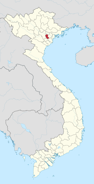
Location of Hưng Yên within Vietnam
|
|
| Country | |
| Region | Red River Delta |
| Capital | Hưng Yên |
| Subdivision | 1 city, 8 rural districts, one town |
| Government | |
| • Type | Province |
| • Body | Hưng Yên Provincial People's Council |
| Area | |
| • Province | 930.22 km2 (359.16 sq mi) |
| Population
(2021)
|
|
| • Province | 1,269,090 |
| • Density | 1,364.290/km2 (3,533.50/sq mi) |
| • Urban | 209,726 |
| Ethnic groups | |
| • Vietnamese | 99.1% |
| • Tày | 0.2% |
| • Thái | 0.2% |
| • Mường | 0.2% |
| • Others | 0.3% |
| Time zone | UTC+07:00 (ICT) |
| Area codes | 221 |
| ISO 3166 code | VN-66 |
| License plate | 89 |
| Climate | Cwa |
Hưng Yên is a province located in the Red River Delta region of northern Vietnam. It covers an area of about 930 square kilometers (359 square miles). As of 2019, over 1 million people live there.
The province includes one main city, eight rural districts, and one district-level town. Hưng Yên sits along the Red River. It shares borders with five other provinces and cities: Bắc Ninh province, Hải Dương province, Hà Nội, Thái Bình province, and Hà Nam province.
Contents
History of Hưng Yên Province
Early History and Dynasties
People have lived in the Hưng Yên area for thousands of years. In ancient times, during the Hồng Bàng dynasty, this land was part of a region called Giao Chỉ. Over many centuries, its name and administrative divisions changed several times.
For example, under the Ngô dynasty, it was known as Dang Chau. Later, during the Lý dynasty and Trần Dynasty, it had names like Thái Bình phủ and Long Hung lo. These names show how the area was organized by different rulers.
Forming Hưng Yên Province
The name Hưng Yên officially appeared in 1831. This was when the Nguyễn dynasty made big changes to how the country was governed. They created new provinces, and Hưng Yên was one of them.
Several smaller districts were combined to form Hưng Yên Province. The main center of the province was first in An Vu and Luong Dien. It later moved to Nhi Tan in Xích Đằng commune, which is now Hưng Yên city. This area became a busy trading hub because of its good location and many markets.
French Colonial Period
From 1831 until 1945, Hưng Yên's borders changed several times. In 1883, French troops arrived in Hưng Yên. They tried to control the area and set up military bases. However, they faced strong resistance from local people, especially during the Bãi Sậy uprising.
To make it easier to control the revolts, the French created a special Bãi Sậy area in 1890. After the rebellion ended, some districts were moved between Hưng Yên and other provinces like Hải Dương province. Also, the Luộc River became a natural border between Hưng Yên and Thái Bình province.
Modern Administrative Changes
After Vietnam gained independence in 1945, the district borders in Hưng Yên mostly stayed the same. However, some smaller areas within the districts changed names.
In 1968, Hưng Yên and Hải Dương provinces were combined to form Hải Hưng province. Then, in the 1970s, many districts within Hải Hưng were merged together. For example, Văn Giang and Yên Mỹ became Văn Yên district.
However, in 1996, the National Assembly decided to split Hải Hưng back into two separate provinces: Hải Dương and Hưng Yên. After this, the merged districts in Hưng Yên were also split back into their original administrative units.
Today, Hưng Yên has ten main administrative areas. These include Hưng Yên city, one district-level town (Mỹ Hào), and eight rural districts. These are Văn Lâm, Văn Giang, Yên Mỹ, Khoái Châu, Ân Thi, Kim Động, Tiên Lữ, and Phù Cừ. Together, they have 161 smaller communes, wards, and towns.
Geography and Climate
Location and Landscape
Hưng Yên is located in the northern part of Vietnam, within the Red River Delta. The land here is mostly flat, with some low hills mixed in with wide plains.
The province is like an eastern gateway to Hanoi, the capital city. It has important roads like National Highway 5A and a railway line connecting Hanoi and Haiphong. Other national highways also pass through Hưng Yên city, linking it to other provinces in the Northern Delta. This makes Hưng Yên an important transport hub.
Hưng Yên is also close to major seaports like Haiphong and Cái Lân. It is also near Noi Bai International Airport. The province borders Hanoi and the provinces of Bắc Ninh, Hà Nam, Thái Bình, and Hải Dương.
Hưng Yên's Climate
Like other areas in the Red River Delta, Hưng Yên has a hot and humid tropical monsoon climate. This means it has two main seasons each year: a hot, wet season and a cooler, drier season.
On average, the sun shines for about 1,519 hours each year. The average temperature is about 23.2°C (73.8°F) in summer and 16°C (60.8°F) in winter.
The province receives a lot of rain, usually between 1,450 mm and 1,650 mm (57 to 65 inches) per year. Most of this rain, about 70%, falls between May and October. The air is quite humid, with an average humidity of 86%.
Natural Resources
Hưng Yên is a flat delta province with no large mountains. It has a lot of land used for farming, about 61,037 hectares (150,826 acres). Most of this land is used for growing crops every year. The rest is for growing plants that live for many years, raising fish, or other special farming. There is also some unused land that can be developed for agriculture.
The province has plenty of fresh water. This is because it is surrounded by the Hồng River and Luộc River. There is also a large supply of underground water. Near National Highway 5A, there are huge underground water sources. These can provide water for factories, cities, and even nearby areas.
Hưng Yên also has a large amount of lignite, which is a type of brown coal. This coal is part of a massive reserve in the Red River Delta, estimated at 30 billion tonnes. While it hasn't been mined yet, it has great potential to provide energy for Vietnam and for export.
Administrative Divisions
Hưng Yên is divided into 10 main areas. These are further split into 161 smaller areas, including communes, wards, and towns.
| Subdivisions of Hưng Yên | |||||||||||||||||||||||||||||||||||||||||||||||
|---|---|---|---|---|---|---|---|---|---|---|---|---|---|---|---|---|---|---|---|---|---|---|---|---|---|---|---|---|---|---|---|---|---|---|---|---|---|---|---|---|---|---|---|---|---|---|---|
|
|
||||||||||||||||||||||||||||||||||||||||||||||
Workforce and Education
Hưng Yên has a growing population, with a natural growth rate of 1% each year. A large part of its population, about 57,000 people, are young and ready for work. This group makes up 51% of the province's total population.
Many of these workers have received training. About 25% of the working population has attended training courses. These include graduates from universities, colleges, and high schools, as well as skilled technical workers. This shows that Hưng Yên has a well-educated and capable workforce.
See also
 In Spanish: Provincia de Hưng Yên para niños
 | James Van Der Zee |
 | Alma Thomas |
 | Ellis Wilson |
 | Margaret Taylor-Burroughs |


