Helena Valley Southeast, Montana facts for kids
Quick facts for kids
Helena Valley Southeast, Montana
|
|
|---|---|

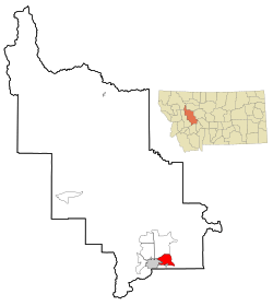
Location of Helena Valley Southeast, Montana
|
|
| Country | United States |
| State | Montana |
| County | Lewis and Clark |
| Area | |
| • Total | 22.41 sq mi (58.04 km2) |
| • Land | 21.47 sq mi (55.61 km2) |
| • Water | 0.94 sq mi (2.44 km2) |
| Elevation | 3,810 ft (1,160 m) |
| Population
(2020)
|
|
| • Total | 9,168 |
| • Density | 427.01/sq mi (164.87/km2) |
| Time zone | UTC-7 (Mountain (MST)) |
| • Summer (DST) | UTC-6 (MDT) |
| Area code(s) | 406 |
| FIPS code | 30-35634 |
Helena Valley Southeast is a special kind of community in Lewis and Clark County, Montana, United States. It's called a "census-designated place" (CDP). This means it's an area that looks like a town but isn't officially a city.
In 2010, about 8,227 people lived here. By 2020, the population grew to 9,168 people. Helena Valley Southeast is also part of the larger Helena area.
Contents
Where is Helena Valley Southeast?
Helena Valley Southeast is located in the southern part of Lewis and Clark County. You can find its exact spot using these coordinates: 46°36′41″N 111°55′24″W / 46.61139°N 111.92333°W.
It shares borders with some other places. To the southwest, it's next to Helena, which is the capital city of Montana. To the south, it borders East Helena. To the north, you'll find the Helena Valley Northeast CDP.
The main road that goes from east to west through the community is Canyon Ferry Road. Downtown Helena is about 7 miles (11 km) southwest from the center of Helena Valley Southeast.
Land and Water
The United States Census Bureau says that Helena Valley Southeast covers a total area of about 22.41 square miles (58.04 square kilometers). Most of this area is land. Only a small part, about 0.94 square miles (2.44 square kilometers), is water.
Who Lives Here?
| Historical population | |||
|---|---|---|---|
| Census | Pop. | %± | |
| 2020 | 9,168 | — | |
| U.S. Decennial Census | |||
In 2000, there were 7,141 people living in Helena Valley Southeast. These people lived in 2,495 homes, and 1,941 of those were families. The population density was about 441 people per square mile (170 people per square kilometer).
Many homes had children under 18 living there. Most households were married couples. Some homes were led by a single parent, often a mother. A smaller number of homes had people living alone, including some who were 65 or older.
The average age of people living in Helena Valley Southeast in 2000 was 31 years old. About 34% of the population was under 18.
Schools in the Area
Students in Helena Valley Southeast go to different school districts depending on where they live.
- If you live in the northern and western parts, you would attend schools in the Helena Elementary School District and the Helena High School District.
- If you live in the southern and eastern parts, you would go to schools in the East Helena K-12 school district. This district covers all grades from kindergarten to 12th grade.
See also
 In Spanish: Helena Valley Southeast para niños

