Hidalgo, Tamaulipas facts for kids
Quick facts for kids
Villa Hidalgo
Hidalgo
|
||
|---|---|---|
|
||

Municipality of Villa Hidalgo
|
||
| Country | ||
| State | Tamaulipas | |
| Founded | May 19 1752 | |
| Area | ||
| • Total | 2,142.43 km2 (827.20 sq mi) | |
| Elevation | 400 m (1,300 ft) | |
| Population
(2000)
|
||
| • Total | 24,281 | |
| Time zone | UTC-6 (Central Standard Time) | |
| • Summer (DST) | UTC-5 (Central Daylight Time) | |
| Postal Code |
87800
|
|
| Website | http://www.vhidalgo.gob.mx | |
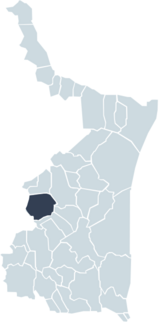
Hidalgo Municipality, also known as Villa Hidalgo, is a special area in the Mexican state of Tamaulipas. Think of a municipality like a county or a local district. It's a way to organize land and people for local government.
Hidalgo is home to El Chorrito, a place many people visit for religious reasons. It's an important spot for pilgrims.
Exploring Hidalgo's Geography
Hidalgo Municipality is located in the state of Tamaulipas, Mexico. It covers a large area of about 2,142 square kilometers. The land here is quite varied.
Understanding Hidalgo's Climate
The weather in Hidalgo is generally warm and a bit humid. This means it can feel sticky sometimes. The average amount of rain each year is about 700 millimeters.
The temperatures in Hidalgo can change a lot. The coldest it gets is around 2 degrees Celsius. The hottest temperature can reach up to 41 degrees Celsius. This wide range means people living here experience both cool and very hot days.
Images for kids
See also
 In Spanish: Municipio de Hidalgo (Tamaulipas) para niños
 | James B. Knighten |
 | Azellia White |
 | Willa Brown |


