Horizontal coordinate system facts for kids
The horizontal coordinate system is a special way to find things in the sky, like stars, planets, or even airplanes. It's also called the topocentric coordinate system because "topo" means "place" and "centric" means "centered," so it's all about your specific location on Earth.
This system uses your local horizon as its main starting point. Think of your horizon as the flat line where the sky meets the Earth all around you.
The horizontal coordinate system is always based on where you are standing. This means that the position of an object in the sky, like its height, will change as time passes. This happens because Earth is always spinning, making objects appear to move across the sky.
Contents
What is the Horizontal Coordinate System?
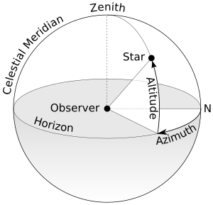
The horizontal coordinate system helps us describe exactly where something is in the sky from our point of view. It's like having a personal sky map that moves with you! This system uses two main measurements to pinpoint objects: altitude and azimuth.
Understanding Altitude and Azimuth
These two measurements work together to give an object's exact spot in the sky.
What is Altitude?
Altitude is how high an object appears above your horizon. Imagine drawing a line from your eye to the object. The altitude is the angle between that line and your flat horizon. If an object is directly overhead, its altitude is 90 degrees. If it's right on the horizon, its altitude is 0 degrees.
What is Azimuth?
Azimuth tells you the direction an object is located around your horizon. It's measured as an angle starting from true north. We usually measure azimuth clockwise (to the right) from north. So, north is 0 degrees, east is 90 degrees, south is 180 degrees, and west is 270 degrees.
Why Do Measurements Change?
Unlike some other sky maps, the horizontal coordinate system is fixed to your spot on Earth, not to the stars themselves. This is why the altitude and azimuth of a star or planet are always changing. As Earth rotates, the sky appears to move above us. This means an object that was high in the sky a few hours ago might now be closer to the horizon.
How We Use This System
This system is very useful for observers on Earth. For example, it helps astronomers plan their observations from a specific observatory. It's also used in navigation and for tracking satellites. If you want to point a telescope at a specific object, you need to know its altitude and azimuth from your location at that exact time.
Images for kids
See also
 In Spanish: Coordenadas horizontales para niños
 | Frances Mary Albrier |
 | Whitney Young |
 | Muhammad Ali |


