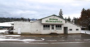
Huson, Montana facts for kids
Quick facts for kids
Huson, Montana
|
|
|---|---|
 |
|
| Country | United States |
| State | Montana |
| County | Missoula |
| Area | |
| • Total | 0.78 sq mi (2.01 km2) |
| • Land | 0.77 sq mi (1.98 km2) |
| • Water | 0.01 sq mi (0.03 km2) |
| Elevation | 3,012 ft (918 m) |
| Population
(2020)
|
|
| • Total | 256 |
| • Density | 334.64/sq mi (129.21/km2) |
| Time zone | UTC-7 (Mountain (MST)) |
| • Summer (DST) | UTC-6 (MDT) |
| ZIP code |
59846
|
| Area code(s) | 406 |
| GNIS feature ID | 785180 |
| FIPS code | 30-38275 |
Huson is a small community in Missoula County, Montana, USA. It's called a "census-designated place" because the government counts its population separately. This happens even though it's not a city or town with its own local government. In 2020, about 256 people lived there. This was a bit more than the 210 people who lived there in 2010.
History of Huson
Huson started as a train station around 1894. It first had a post office named Glaude in 1897. But about a year later, its name was changed to Huson.
Where is Huson?
Huson is located in the northwest part of Missoula County. It sits in the valley of the Clark Fork River, which runs along the community's southern edge.
You can reach Huson from Exit 85 on Interstate 90. This highway goes about 20 miles (32 km) southeast to the city of Missoula. It also goes about 38 miles (61 km) northwest to Superior.
According to the U.S. Census Bureau, the Huson area covers about 0.78 square miles (2.01 km²). Most of this area is land, with only a small part, about 0.01 square miles (0.03 km²), being water.
How Many People Live in Huson?
The number of people living in Huson has changed over time.
| Historical population | |||
|---|---|---|---|
| Census | Pop. | %± | |
| 2010 | 210 | — | |
| 2020 | 256 | 21.9% | |
| U.S. Decennial Census | |||
Schools in Huson
Students in Huson attend Frenchtown Public Schools. This school district serves students from kindergarten all the way through 12th grade.
See also
 In Spanish: Huson (Montana) para niños


