
Image: 1710 moll

Size of this preview: 800 × 491 pixels. Other resolutions: 320 × 196 pixels | 3,845 × 2,359 pixels.
Original image (3,845 × 2,359 pixels, file size: 11.03 MB, MIME type: image/jpeg)
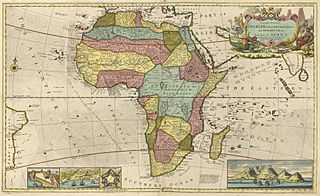
Description: Early map of Africa depicting a region named Biafra
Title: 1710 moll
Credit: http://libweb5.princeton.edu/visual_materials/maps/websites/africa/maps-continent/1710%20moll.jpg
Author: Herman Moll
Usage Terms: Public domain
License: Public domain
Attribution Required?: No
Image usage
The following page links to this image:

All content from Kiddle encyclopedia articles (including the article images and facts) can be freely used under Attribution-ShareAlike license, unless stated otherwise.