
Image: 1852 Stansbury Map of Utah and the Great Salt Lake - Geographicus - GreatSaltLake-stansbury-1852
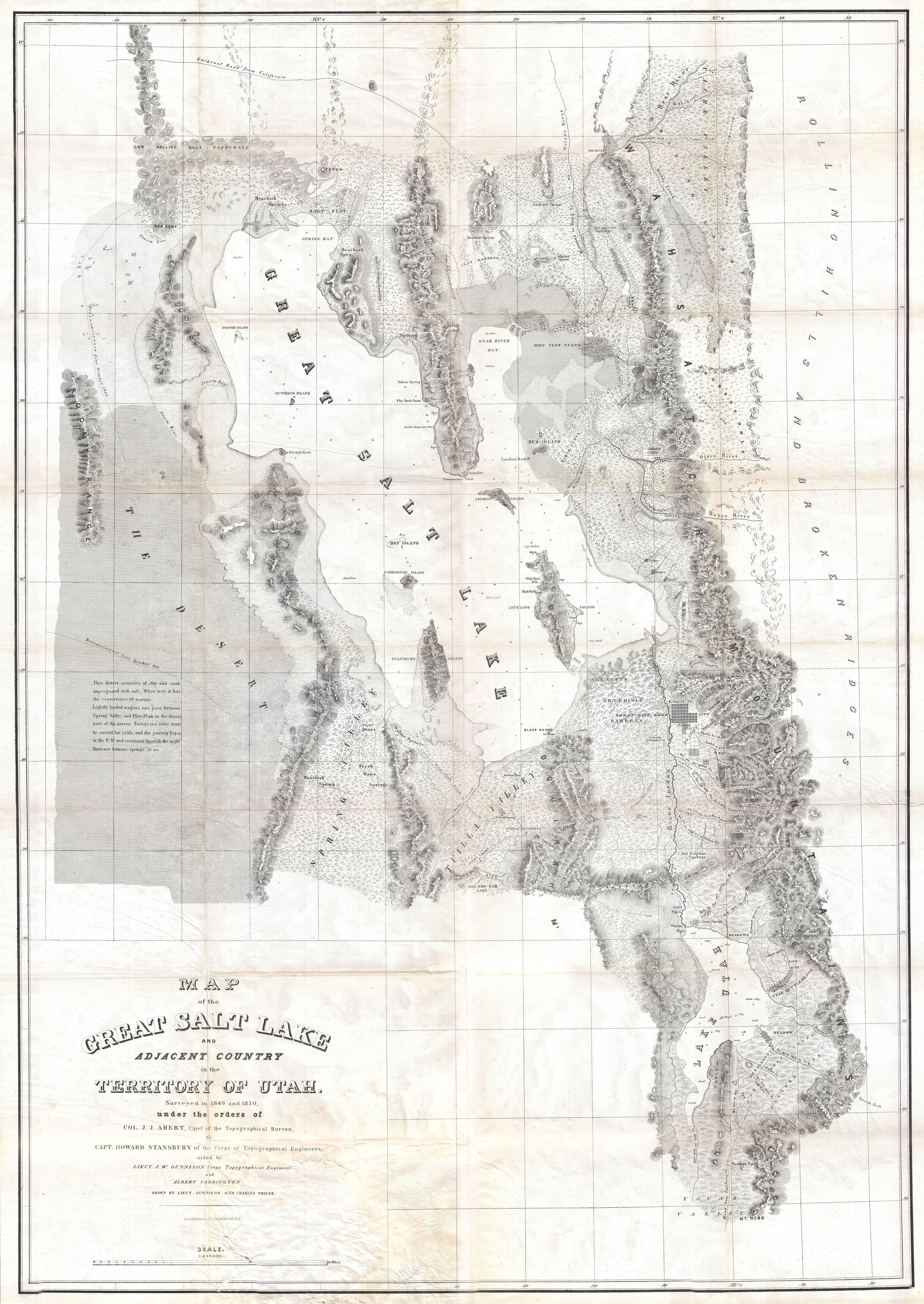
Description: It had been a daring feat of exploration, succeeding where the mountain men had all failed, and by means of his map of the western portion of the lake, Stansbury had painted at least one more bold stroke into the unfinished portrait of the national landscape. - William Goetzmann This is Stansbury's seminal 1852 map of the Great Salt Lake region in Utah. It is considered to be the first accurate survey of the Great Basin as well as a cornerstone achievement in the mapping of the American West. The first westerner to visit the Great Basin was most likely Silvestre Vélez de Escalante in the 1776, however, Escalante, who visited Utah Lake to the south, never truly laid eyes on Great Salt Lake. That honor would fall to unnamed trappers and mountain men traveling the region in search of furs and other tradable commodities. Unfortunately, few of these men were literate and did not record their discoveries. The first scientific expedition to this area was headed up by Fremont in 1843. Daunted by the season and climate, Fremont never circumnavigated the lake. That task fell to Howard Stansbury who, in 1849, was assigned by Congress to survey the Great Salt Lake, the Utah Valley, and the emigrant roads passing through the region. Stansbury, working with Gunnison, Carrington, and others, took about two years to complete his survey before presenting it to Congress in 1852. This map was part of that presentation. Covering the region of the Great Basin from the Bear River in the north to Mount Nebo in the south, and from the Rocky Mountains in the west to the Great Plains in the east, Sansbury's map is the result of a monumental feat of exploration and scientific tenacity. The detail throughout is extraordinary, identifying springs, rivers, passes, important buildings, American Indian settlements, canals, etc. Stansbury's work and this map are responsible for creating much of the region's nomenclature, but where it is not, both Mormon and American Indian names are provided. This is also one of the earliest maps to delineate the street plan of Salt Lake City. Stansbury attempts to provide useful information for the traveler. Both the Emigrant Road from California (passing north of the lake) and the Road From California (Passing South of the Lake) are shown. He also provides useful notations for the traveler, such as this one in the lower left quadrant This desert consists of clay and sand impregnated with salt. When wet, it has the consistency of mortar. Lightly loaded wagons can pass between Spring Valley and Pilot Peak in the driest part of the season. Forage and water must be carried for cattle, and the journey begun in the P. M. and continued through the night. Distance between springs 70 ms. . As much as possible, Stansbury includes nautical details and depth sounding for both Great Salt Lake and Utah Lake. In the process of creating a marine survey of the Lake, the Stansbury team was also the first to identify and chart many of Great Salt Lake's Islands ,as might be deduced form their names: Stansbury Island, Carrington Island, Gunnison Island, and Fremont Island. Wheat, in his classic study of American exploration, Mapping the Transmississippi West , devotes considerable attention to this important map, Obviously a major production...an illuminating map of Great Salt Lake, Utah Lake, their respective valleys, and a portion of ‘Youab’ (Juab) Valley to the south.... This map permanently established the cartography and many place names of northwestern Utah.... One of its most attractive features is that it gives the Indian as well as the Mormon names of the various creeks draining from the mountains. For Great Salt Lake itself the map was definitive, of course, permanent names being given to all the islands and shoreline features....
Title: Map of the Great Salt Lake and Adjacent Country in the Territory of Utah.
Credit: This file was provided to Wikimedia Commons by Geographicus Rare Antique Maps, a specialist dealer in rare maps and other cartography of the 15th, 16th, 17th, 18th and 19th centuries, as part of a cooperation project.
Author: http://www.geographicus.com/mm5/cartographers/stansbury.txt
Permission: This is a faithful photographic reproduction of a two-dimensional, public domain work of art. The work of art itself is in the public domain for the following reason: Public domainPublic domainfalsefalse This work is in the public domain in its country of origin and other countries and areas where the copyright term is the author's life plus 70 years or fewer. You must also include a United States public domain tag to indicate why this work is in the public domain in the United States. Note that a few countries have copyright terms longer than 70 years: Mexico has 100 years, Jamaica has 95 years, Colombia has 80 years, and Guatemala and Samoa have 75 years. This image may not be in the public domain in these countries, which moreover do not implement the rule of the shorter term. Côte d'Ivoire has a general copyright term of 99 years and Honduras has 75 years, but they do implement the rule of the shorter term. Copyright may extend on works created by French who died for France in World War II (more information), Russians who served in the Eastern Front of World War II (known as the Great Patriotic War in Russia) and posthumously rehabilitated victims of Soviet repressions (more information). This file has been identified as being free of known restrictions under copyright law, including all related and neighboring rights. https://creativecommons.org/publicdomain/mark/1.0/PDMCreative Commons Public Domain Mark 1.0falsefalse The official position taken by the Wikimedia Foundation is that "faithful reproductions of two-dimensional public domain works of art are public domain". This photographic reproduction is therefore also considered to be in the public domain in the United States. In other jurisdictions, re-use of this content may be restricted; see Reuse of PD-Art photographs for details. Template:PD-Art template without license parameter: please specify why the underlying work is public domain in both the source country and the United States (Usage: Template:PD-Art, where parameter #1 can be PD-old-auto, PD-old-auto-expired, PD-old-auto-1996, PD-old-100 or similar. See Commons:Multi-license copyright tags for more information.)
Usage Terms: Public domain
License: Public domain
Attribution Required?: No
Image usage
The following page links to this image:
