
Image: 1870 Knapp Map of Northern Manhattan ( New York City ), Harlem, Washington Heights, Inwood - Geographicus - NorthernManhattan-knapp-1870

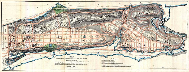
Description: A rare and unusual map of upper Manhattan, New York City, prepared and printed for inclusion in the 1870 Thirteenth Annual Report of the Board of Commissioners of the Central Park. Depicts the island of Manhattan north of 155th street including the districts of Inwood, Harlem, and Washington Heights. The plan for much of Manhattan, south of 155th street, was originally laid out by John Randel in his 1811 Map of the City of New York or as it is otherwise known the “Commissioner’s Plan”. This ambitions project transformed nearly 12,000 acres of wilderness into a massive urban grid. Nonetheless, by 1860, New York City’s development had exceeded even Randel’s expectations. The Central Park Commission was granted the responsibility of laying out the systematic street gird and public areas of the undeveloped parts of Manhattan northwards of 155th street. Consequently the 1870 13th Annual Commissioner’s Report included this map which offers considerable detail regarding proposed street layouts, waterways, and public areas, both proposed and developed. Also depicts the suggested bulkhead development extending the shoreline along both the eastern and western parts of Manhattan Island. When this map was made much of this region remained undeveloped farmland and semi-suburban properties, as is reflected by some of the topography and buildings indicated, especially in the western part of the city. Numerous individual buildings are sketched in if not specifically described. Also apparent is the newly developed 11th Avenue, a critical artery connecting lower Manhattan with the Harlem and Hudson waterways in the northern part of the city. A rare and important map regarding the development of modern New York City.
Title: Map of that Part of the City of new York North of 155th Street Showing the progress made in laying out Streets, Roads, Public Squares, and Places, by the Commissioners of the Central Park, under Chap. 565 of Laws of 1865 and of new Pier and Bulkhead lines under Chap. 697 of Laws of 1867.
Credit: This file was provided to Wikimedia Commons by Geographicus Rare Antique Maps, a specialist dealer in rare maps and other cartography of the 15th, 16th, 17th, 18th and 19th centuries, as part of a cooperation project.
Author: http://www.geographicus.com/mm5/cartographers/sarony.txt
Permission: This is a faithful photographic reproduction of a two-dimensional, public domain work of art. The work of art itself is in the public domain for the following reason: Public domainPublic domainfalsefalse This work is in the public domain in its country of origin and other countries and areas where the copyright term is the author's life plus 70 years or fewer. You must also include a United States public domain tag to indicate why this work is in the public domain in the United States. Note that a few countries have copyright terms longer than 70 years: Mexico has 100 years, Jamaica has 95 years, Colombia has 80 years, and Guatemala and Samoa have 75 years. This image may not be in the public domain in these countries, which moreover do not implement the rule of the shorter term. Côte d'Ivoire has a general copyright term of 99 years and Honduras has 75 years, but they do implement the rule of the shorter term. Copyright may extend on works created by French who died for France in World War II (more information), Russians who served in the Eastern Front of World War II (known as the Great Patriotic War in Russia) and posthumously rehabilitated victims of Soviet repressions (more information). This file has been identified as being free of known restrictions under copyright law, including all related and neighboring rights. https://creativecommons.org/publicdomain/mark/1.0/PDMCreative Commons Public Domain Mark 1.0falsefalse The official position taken by the Wikimedia Foundation is that "faithful reproductions of two-dimensional public domain works of art are public domain". This photographic reproduction is therefore also considered to be in the public domain in the United States. In other jurisdictions, re-use of this content may be restricted; see Reuse of PD-Art photographs for details. Template:PD-Art template without license parameter: please specify why the underlying work is public domain in both the source country and the United States (Usage: Template:PD-Art, where parameter #1 can be PD-old-auto, PD-old-auto-expired, PD-old-auto-1996, PD-old-100 or similar. See Commons:Multi-license copyright tags for more information.)
Usage Terms: Public domain
License: Public domain
Attribution Required?: No
Image usage
The following page links to this image:

,_Harlem,_Washington_Heights,_Inwood_-_Geographicus_-_NorthernManhattan-knapp-1870.jpg)