
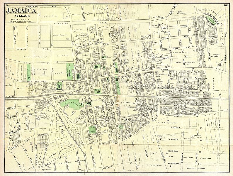
Image: 1873 Beers Map of Jamaica Village, Queens, New York City - Geographicus - JamaicaVillage-beers-1873

Description: A scarce example of Frederick W. Beers’ map of the town of Jamaica Village, Queens, New York. Published in 1873. Covers roughly from modern day Highland Avenue to Atlantic Avenue, and from Myrtle Avenue to Franklin Avenue. Detailed to the level of individual buildings and properties with land owners noted. This is probably the finest atlas map of the town of Jamaica Queens, to appear in the 19th century. Prepared by Beers, Comstock & Cline out of their office at 36 Vesey Street, New York City, for inclusion in the first published atlas of Long Island, the 1873 issue of Atlas of Long Island, New York.
Title: Jamaica Village, Queens Co. L.I.
Credit: This file was provided to Wikimedia Commons by Geographicus Rare Antique Maps, a specialist dealer in rare maps and other cartography of the 15th, 16th, 17th, 18th and 19th centuries, as part of a cooperation project.
Author: http://www.geographicus.com/mm5/cartographers/beers.txt
Permission: Public domain works must be out of copyright in both the United States and in the source country of the work in order to be hosted on the Commons. If the work is not a U.S. work, the file must have an additional copyright tag indicating the copyright status in the source country. Note: This tag should not be used for sound recordings.PD-1923Public domain in the United States//commons.wikimedia.org/wiki/File:1873_Beers_Map_of_Jamaica_Village,_Queens,_New_York_City_-_Geographicus_-_JamaicaVillage-beers-1873.jpg
Usage Terms: Public domain
License: Public domain
Attribution Required?: No
Image usage
The following page links to this image:
