
Queens directories facts for kids

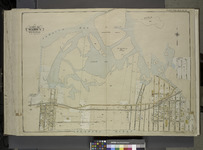
Map of Queens
|
Queens Directories are like old phone books and history guides for Queens, New York City. Before 1898, Queens was much larger and mostly farmland, with many small towns and villages. These directories were separate books for each village or for the whole Queens County. Sometimes, parts of Queens were even included in New York City directories.
In 1898, a big change happened! About 30% of western Queens County became part of New York City. The eastern 70% of the old Queens County became Nassau County. Today, Queens County and the Borough of Queens are the same place. Both Queens and Brooklyn are located on Long Island. This article will help you learn about the history of Queens and its people.
Key Moments in Queens History
Queens has a long and interesting history! Here are some important events and facts.
Early Towns and Communities (Before 1898)
Before Queens became part of New York City, it had many small towns and communities.
| Communities Before 1898 | ||
|---|---|---|
| Year | Place | What Happened |
| Long Island | Native Americans called Long Island "Paumanok," meaning "The Island that Pays Tribute." European settlers later called it "Nassau Island" and then "Island of Stirling." Over time, different groups claimed ownership. In 1641, much of the eastern part was sold to the New Haven and Connecticut Colonies. | |
| 1645: | Flushing | The original land grant for Flushing was signed on October 10, 1645. Several people received this land from Willem Kieft, who was the Director-General of New Netherland. |
| 1652: | Elmhurst | Elmhurst, Queens was first called Middelburgh in 1652 by English settlers. When the British took over in 1664, its name changed to Hastings, then New Towne (Newtown) in 1665. In 1896, it was renamed Elmhurst. |
| 1683: | Province of New York | On November 1, 1683, the British colony of New York was divided into twelve counties. Queens was one of them, and it included what is now Nassau County. |
| 1683: | New York City Wards | New York City was split into "wards" from 1683 to 1938. These wards were used for elections. Before 1898, different parts of what is now New York City had their own ways of dividing up areas. |
| 1785 | New-York Manumission Society | This group was formed in 1785 to fight against slavery. In 1788, New York State passed a law allowing slave owners to free enslaved people. This process was called "manumit." Owners needed a certificate saying the person was under 50 and could support themselves. |
| 1799 | Gradual Emancipation Act | In 1799, New York passed a law to slowly end slavery. It didn't free anyone right away. Instead, children born to enslaved mothers after this date had to work for their mother's owner until they were 28 (for boys) or 25 (for girls). The last enslaved people were freed by this law on July 4, 1827. African Americans celebrated with a parade. |
| 1836: | College Point | In 1836, a priest named William Augustus Muhlenberg started St. Paul's College here. Before that, a man named William Lawrence owned a lot of land in the area. Later, parts of the land were sold and developed into villages like Strattonport and Flammersburg. By 1856, these areas were all known as College Point. Many German immigrants moved here, so it was sometimes called "Little Heidelberg." |
| 1837: | Village of Flushing | The Village of Flushing officially became a village on April 15, 1837. |
| 1861–1865: | Civil War | No big battles happened on Long Island during the Civil War. However, New York State lost about 39,000 people, more than any other state. Directories from this time, like one by William Andrew Boyd in 1864, listed people in Astoria, Flushing, Jamaica, and Newtown. |
| 1865: | Blissville | Blissville was named after Neziah Bliss, who bought land in the area in 1837. His son, Archibald Meserole Bliss, later became a U.S. Congressman. |
| 1870: | Long Island City | People predicted that the area around Hunters Point would become a city. On May 4, 1870, Long Island City was officially created. It combined the village of Astoria and several smaller communities. It had between 12,000 and 15,000 residents. |
| 1882: | Ozone Park | This neighborhood was named "Ozone Park" to suggest fresh air. Developers Benjamin W. Hitchcock and Charles C. Denton bought farmland here after a railroad opened in 1880. They wanted to promote the idea of cool, clean breezes from the ocean. |
| 1886: | Bowery Bay Beach | Bowery Bay Beach, later called North Beach, opened in 1886. It was a popular spot known as the "Coney Island of Queens." |
| 1889: | Murray Hill | Murray Hill in Queens is named after William King Murray, a local plant expert. He sold land to a real estate company. The original Murray Hill in Manhattan is named after Robert Murray, a merchant. |
| 1890: | Trow Settlement | In 1890, John Libby and three others bought a block in Beechhurst. This area was settled by employees of the Trow City Directory Company and was known as the "Trow Settlement." |
| 1897: | Consolidation Authorized | The creation of the New York City borough of Queens was approved on May 4, 1897. This happened after people voted for it in 1894. The eastern part of Queens, which became Nassau County, was separated on January 1, 1899. Queens Borough officially started on January 1, 1898. |
| 1898: | Consolidation Occurred | On January 1, 1898, New York City grew much larger. It took in the East Bronx, Brooklyn, western Queens County, and Staten Island. From Queens, this included Flushing, Jamaica, Long Island City, Newtown, and part of the Rockaway Peninsula. The rest of Queens County became Nassau County in 1899. |
Where Names Come From
Many places in Queens have interesting stories behind their names!
| Name Origins | |
|---|---|
| Place | Meaning or Story |
| Hunters Point | This area was first called Dominie's Hoek, named after Everardus Bogardus. Later, the land became a large farm owned by Jacob Bennett. After he died, it went to his daughter and son-in-law, Anne and George Hunter, which is where "Hunters Point" comes from. |
| Jamaica | The name "Jamaica" comes from the "Jameco" Native American tribe. In their language, Algonquin, "Jameco" means "place of beaver." This is because the Jameco people lived near what became known as Jamaica Bay and Beaver Stream, where beavers were common. |
New Neighborhoods (After 1898)
After Queens joined New York City, many new neighborhoods were developed.
| Neighborhoods After 1898 | ||
|---|---|---|
| 1901: | Auburndale | Auburndale, located east of Flushing, was once a 117-acre farm. In 1901, it was sold to a company that divided it into lots and streets, renaming it Auburndale. The Long Island Rail Road opened a station here in May 1901. The name comes from Auburndale, Massachusetts, where the company's president lived. |
| 1909: | Jackson Heights | Before 1909, this area was known as Trains Meadow. |
| 1925: | Rego Park | Rego Park and Middle Village were settled by Dutch farmers in 1653 and called Whitepot. The name "Rego" is a mix of "Real Good Construction Company," which started building homes in the area in 1925. |
| 1970: | Flushing | Flushing is home to one of New York City's largest Asian American communities. The first wave of immigrants from Taiwan arrived in the 1970s, helping the area grow. Other Asian communities are found in Manhattan and Brooklyn. |
Connecting Queens: Bridges and Tunnels
Queens is connected to other parts of New York City by many bridges and tunnels. These are very important for travel!
Bridges Over Dutch Kills
Dutch Kills is a waterway in Long Island City. Here are some bridges that cross it.
| Dutch Kills Bridges | |
|---|---|
| 1893: | The Dutch Kills Swing Bridge, in Long Island City, opened in 1893. It was designed to swing open for boats, but now it's fixed in place. It carries one freight track for the Long Island Railroad. |
| 1908: | The Borden Avenue Bridge opened on March 25, 1908. It's a special bridge that slides back to let boats pass. It carries cars and people across Dutch Kills. |
| 1910: | The Hunters Point Avenue Bridge is 500 feet long and opened in 1910. It carries Hunters Point Avenue. |
| 1910: | The Cabin M Bridge is a railroad bridge over Dutch Kills Creek. It was built in 1910 and used to have more tracks. "Cabin M" was the name of an old train control tower. |
Bridges Over the East River
The East River separates Queens from Manhattan and the Bronx. Many famous bridges cross it.
| East River Bridges | |
|---|---|
| 1883: | The Brooklyn Bridge opened on May 24, 1883. It was the first bridge to connect Brooklyn to Lower Manhattan. |
| 1909: | The Queensboro Bridge (also called the 59th Street Bridge) opened on March 30, 1909. It connects Long Island City with the Upper East Side of Manhattan, passing over Roosevelt Island. It used to have train tracks on its upper level. |
| 1909: | The Manhattan Bridge opened on December 31, 1909. It also connects Brooklyn to Lower Manhattan. |
| 1917: | The Hell Gate Bridge, for trains, opened on March 9, 1917. It connects Astoria in Queens with Randalls and Wards Islands in Manhattan, linking Manhattan, the Bronx, and Queens. |
| 1936: | The Triboro Bridge, which connects Manhattan, the Bronx, and Queens, opened on July 11, 1936. |
| 1939: | The Bronx–Whitestone Bridge opened on April 29, 1939. |
| 1955: | The Roosevelt Island Bridge, connecting Roosevelt Island with Long Island City, opened on May 18, 1955. |
| 1961: | The Throgs Neck Bridge opened on January 11, 1961. It carries six lanes of traffic over the East River, connecting the Bronx with Bay Terrace, Queens in Queens. |
Tunnels Under the East River
Tunnels also connect Queens to other boroughs, especially for trains and cars.
| East River Tunnels | |
|---|---|
| 1910: | The East River Tunnels opened on September 8, 1910. These four tunnels carry trains from Penn Station in Manhattan to Long Island City. They are used by the Long Island Rail Road and Amtrak. |
| 1915: | The Steinway Tunnel opened on June 13, 1915. It carries the IRT Flushing Line subway under the East River, connecting Manhattan and Long Island City. |
| 1940: | The Queens–Midtown Tunnel opened on November 15, 1940. It goes under the East River, connecting Midtown Manhattan to Long Island City. |
Bridges Over Newtown Creek
Newtown Creek forms part of the border between Queens and Brooklyn.
| Newtown Creek Bridges | |
|---|---|
| 1830s: | Penny Bridge crossed Newtown Creek, connecting Newtown (now Elmhurst) with Bushwick. It was named "Penny Bridge" because pedestrians had to pay one penny to cross. It was taken down in 1939. |
| 1852: | In 1852, Neziah Bliss opened the first drawbridge, called the Blissville Bridge. It crossed Newtown Creek, connecting Greenpoint, Brooklyn with Blissville, Queens. This bridge helped Greenpoint grow as an industrial area. |
| 1902: | The Grand Street Bridge opened in 1902. It's a swing bridge that connects Brooklyn and Queens over Newtown Creek. |
| 1933: | The Metropolitan Avenue Bridge, a drawbridge, opened on March 27, 1933. It crosses English Kills, a part of Newtown Creek. |
| 1939: | The Pulaski Bridge opened on September 10, 1954. It crosses Newtown Creek, connecting Long Island City to Greenpoint, Brooklyn. |
| 1987: | The Greenpoint Avenue Bridge (also called J. J. Byrne Memorial Bridge) opened in 1987. It carries Greenpoint Avenue across Newtown Creek, connecting Blissville, Queens, with Greenpoint, Brooklyn. |
| 2017: | The new Kosciuszko Bridge opened in April 2017. It connects Greenpoint, Brooklyn to Maspeth in Queens. |
Bridges Over Flushing River
The Flushing River also has important bridges and crossings.
| Flushing River Bridges | |
|---|---|
| 1938: | The Long Island Rail Road's Port Washington Branch has a trestle (a type of bridge) here. |
| 1938: | The Porpoise Bridge is a vehicle bridge over Flushing Creek. It was built in 1938 as a "tidal gate" to control water flow. |
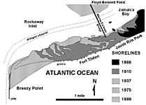
Bridges Over Jamaica Bay
Jamaica Bay is a large bay on the southern side of Queens.
| Jamaica Bay Bridges | |
|---|---|
| 1970: | The Cross Bay Veterans Memorial Bridge opened on May 28, 1970. It's a toll bridge that carries Cross Bay Boulevard across Jamaica Bay, connecting Broad Channel and the Rockaway Peninsula. |
| 1988: | The Joseph P. Addabbo Memorial Bridge opened on October 25, 1988. This six-lane bridge carries Cross Bay Boulevard across Jamaica Bay, connecting Howard Beach and Broad Channel. |
| 1956: | The North Channel Swing Bridge opened between 1956 and 1958. It carries the A train from Howard Beach to Broad Channel. |
| 1956: | The Beach Channel Drawbridge opened between 1956 and 1958. It carries a subway line over Jamaica Bay into the Rockaways. |
Rockaway Inlet Bridge
The Rockaway Inlet is another important waterway.
| Rockaway Inlet Bridge | |
|---|---|
| 1937: | The Marine Parkway–Gil Hodges Memorial Bridge opened on July 3, 1937. It's a vertical-lift bridge that crosses the Rockaway Inlet, connecting the Rockaway Peninsula in Queens with Brooklyn. |
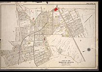
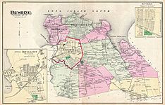
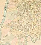
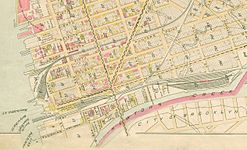
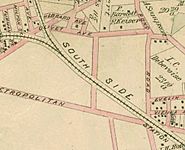
Map Gallery
Here are some historical maps that show how Queens has changed over time.


- Maps of Queens neighborhoods, villages, and towns
-
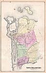
Borough of Queens
(1909) -
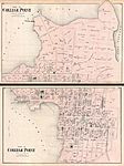
College Point, Queens
(1873) -
Flushing, College Point, Whitestone, Bayside, Douglaston–Little Neck
(1873) -
Flushing
(1891) -
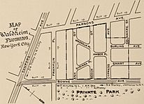
Waldheim
(1917) -
Whitestone Village
(1873) -
Astoria and Long Island City
(1873) -
Long Island City
(1896) -
Hunters Point
(1891) -
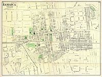
Jamaica Village
(1873) -
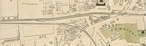
Jamaica railroad stations
(1873) -
Fresh Pond
(1891) -
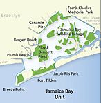
Jamaica Bay Wildlife Refuge
(2010) -
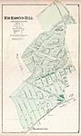
Richmond Hill
(1873) -
Richmond Hill Station
(1891) -
Woodhaven
(1873) -
Edgemere
(1907) -
Breezy Point
(n.d.) -
Jamaica Bay Unit
(2010)

_-_Geographicus_-_CollegePoint-beers-1873.jpg)


_(14759686276).jpg)


.jpg)


Queens Neighborhoods Today
Queens is a very diverse borough with many unique neighborhoods. Here's a look at some of them.
Keep in mind that neighborhoods don't have official borders, so their exact edges can vary.
Northwestern Queens
- Astoria
- Astoria Heights
- Ditmars
- Little Egypt
- Norwood Gardens
- Ravenswood
- Jackson Heights
- Long Island City
- Sunnyside
- Sunnyside Gardens
- Sunnyside Yard
Northeastern Queens
- Bayside
- Bayside Gables
- Bay Terrace
- Bayside Hills
- Fort Totten
- Oakland Gardens
- Lawrence Cemetery
- Bellerose
- College Point
- Douglaston–Little Neck
- Douglaston
- Douglas Bay
- Douglas Manor
- Douglaston Hill
- Douglaston Park
- Winchester Estates
- Douglaston Historic District
- Douglaston Hill Historic District
- Little Neck
- Douglaston
- Flushing
- Flushing Chinatown
- Auburndale
- Broadway-Flushing
- Chinatown
- Downtown Flushing
- Kew Gardens Hills
- Linden Hill
- Murray Hill
- Koreatown
- Kissena Corridor Park (south of Murray Hill)
- Willets Point
- Flushing Meadows–Corona Park
- Shea Stadium
- Citi Field
- 1939 New York World's Fair
- USTA Billie Jean King National Tennis Center
- 1964 New York World's Fair
- New York Hall of Science
- Flushing Meadows Natatorium
- Corona Ash Dumps (1920s)
- Pomonok
- Floral Park, Queens
- Fresh Meadows
- Glen Oaks
- Whitestone
- Beechhurst
- Clearview
- Malba
Central Queens
- Briarwood
- Corona
- East Elmhurst
- Lent Homestead and Cemetery
- LaGuardia Airport
- Elmhurst
- Forest Hills
- Forest Hills Gardens
- West Side Tennis Club
- Forest Hills Co-op
- Forest Hills Gardens
- Glendale
- Kew Gardens
- Maspeth
- Mount Olivet Cemetery
- Middle Village
- Juniper Park
- Remsen Cemetery
- Rego Park
- Ridgewood
- Wyckoff Heights
- Fresh Pond
- Fresh Pond–Traffic Historic District
- Woodside
- Little Manila
- Boulevard Gardens
- Moore-Jackson Cemetery
Southeastern Queens
- Brookville (also known as Springfield Gardens)
- Cambria Heights
- Hollis
- Jamaica
- Jamaica Estates
- Jamaica Hills
- Rochdale Village
- John F. Kennedy International Airport
- Prospect Cemetery
- Laurelton
- Meadowmere
- Queens Village
- Rosedale
- St. Albans
- South Jamaica
- Baislely Park
- South Jamaica Houses
Southwestern Queens
- The Hole
- Howard Beach
- Hamilton Beach
- Howard Park
- Lindenwood
- Old Howard Beach
- Ramblersville
- Rockwood Park
- Jamaica Bay Wildlife Refuge (south of Howard Beach)
- Ozone Park
- Centreville
- South Ozone Park
- Aqueduct Racetrack
- Tudor Village
- Richmond Hill
- Little Pubjab
- Woodhaven
The Rockaways
- Rockaway Peninsula
- Far Rockaway
- Wavecrest
- Bayswater
- Edgemere
- Arverne
- Somerville
- Hammels
- Rockaway Beach
- Seaside
- Rockaway Park
- Belle Harbor
- Neponsit
- Breezy Point
- Roxbury
- Broad Channel (next to the Rockaways)
Old Queens Communities and Land Names
Many places in Queens used to have different names or were part of smaller communities that no longer exist.
Northwestern Queens
- Astoria
- Astoria Village
- Hallet's Cove
- Steinway Village
- Jackson Heights
- Trainsmeadow (Trains Meadow)
- Long Island City
- Arleigh Gardens
- Norwood Gardens
- The German Settlement (starting in the 1870s)
Northeastern Queens
- College Point
- Tew's Neck
- Lawrence's Neck
- Flammersburg
- Strattonport
- Flushing
- Waldheim
- Hinsdale
- Flushing Highlands neighborhoods
- Bowne Park
- Ingleside
- Flushing Park
- Whitestone
- Beechhurst
- Trow Settlement
- Beechhurst
Central Queens
- Elmhurst (Newtown)
- Middelburgh (1652–1664)
- New Towne (1665–1896)
- Steinway (a small community that joined Long Island City in 1870)
- Bowery Bay (a small community that joined Long Island City in 1870)
- Middleton (a small community that joined Long Island City in 1870)
- Mussel Island
- West Maspeth
- Melvina (a small community)
- Laurel Hill / West Maspeth
- Berlinville (started in the 1870s)
- Woodside
- Ridgewood
- Linden Hill
- Middle Village
- Whitepot
Southeastern Queens
- Hollis
- Holliswood
- Terrace Heights
- Holliswood
- Jamaica
- Springfield
- Queens Village
- Creedmoor
Southwestern Queens
- Howard Beach
- Ramblersville (became Howard Beach in 1916)
The Rockaways
- Rockaway, Queens
- Somerville (now called Arverne)
- Far Rockaway
- Wave Crest
- The Village of Creedmoor (now part of Queens Village and Glen Oaks) was once a famous rifle range. In 1872, New York State bought 70 acres of land from Bernardus Hendrickson Creed to create it. The name "Creedmoor" came from "Creed's Moor," referring to Creed's land. The Central Railroad of Long Island opened a branch to Creedmoor in 1873. The rifle range hosted international competitions. However, due to less public interest and noise complaints, the land was given back to the state in 1892. In 1908, it became part of a state hospital, which later became the Creedmoor Psychiatric Center. Some of the land is now part of the Queens County Farm Museum.
- Mussel Island was a small, marshy piece of land where Maspeth Creek and Newtown Creek met. No one ever lived there.
Wikimedia Commons
- Old maps of Queens
- Maps of Queens
- Beers maps of Long Island (1873)
- Bromley maps of Queens (1909)
- Travel maps of Queens
- Neighborhoods in Queens, New York City
