
Juniper Valley Park facts for kids

Juniper Valley Park is a large public park in Middle Village, Queens, New York. It covers about 55 acres (22 hectares). The park is surrounded by Juniper Boulevard North, Juniper Boulevard South, Lutheran Avenue, and Dry Harbor Road. It is also split into two parts by 80th Street.
The park has many sports areas, including courts for tennis, handball, paddleball, basketball, and bocce. There are also seven baseball fields and a running track that is a quarter-mile long. This track goes around a field used for football and soccer. The New York City Department of Parks and Recreation has managed the park since the 1930s. You can get to the park using the Q29, Q38, Q47 buses.
Contents
How Juniper Valley Park Was Formed
The park sits on what used to be Juniper Swamp. This swamp was a low area created by water from melting glaciers. These glaciers formed Long Island about 10,000 to 20,000 years ago. Before the 1900s, Juniper Swamp covered a large area. The cool climate after the glaciers melted helped create peat bogs. These bogs had acidic soil, which was perfect for special plants unique to New York City. Wild blueberry plants also grew there, and early settlers used to pick them.
The Park's History
Early Days of the Area

During the American Revolutionary War in the 1700s, British soldiers cut down most of the trees in the area. Some of the swamp's peat was dug up and burned for heat. Later, white cedar and eastern red cedar trees (which are a type of juniper) grew there. These trees gave the swamp its name. In the winter, when the swamp's ponds froze, people would go ice skating there. This was one of the first fun uses of the area.
In 1822, a farmer named Thomas Pullis bought about 32 acres (13 hectares) of land on the eastern side of the swamp. By 1846, he started a family cemetery on his farm. This cemetery is still inside Juniper Valley Park today. It is one of the few old farm burial grounds left in New York City.
In 1916, the New York Connecting Railroad built a deep cut through the eastern part of the swamp for a new train route. This helped drain a lot of the swamp's water. Since then, this railroad has been the western edge of the park.
In the 1920s, the area east of the railroad and west of where the tennis courts are now was called Metropolitan Heights Fairground. It was used as a race track for horses, dogs, cars, and motorcycles. The track was about 0.875 miles (1.4 kilometers) long.
How the Park Was Developed
A person named Arnold Rothstein was involved in the swamp becoming a park. In the 1920s, he tried to sell the swamp to New York City to build an airport. He even built fake houses to make the land seem more valuable. However, he passed away in 1928 before he could sell it.
In 1927, Herbert Hoover, who was then the United States Secretary of Commerce, helped create a committee to find good places for an airport in New York. This committee suggested Juniper Valley as the best spot for an airfield. However, the city's engineer, Clarence D. Chamberlin, chose a different location called Barren Island because it was already flat and owned by the city. The Barren Island airport later became Floyd Bennett Field.
In 1930, the Regional Plan Association suggested building an airport and a community center in Juniper Valley. They thought it was a good spot because it was close to the New York Connecting Railroad. They believed that with new train lines, the airport and center would be only 15 minutes from Times Square. Also, the Triborough Bridge and Queens–Midtown Tunnel would connect the area to roads like the Long Island Expressway. However, the Queens borough president, George U. Harvey, did not want to build on the land that Rothstein had owned.
In March 1931, New York City Comptroller Charles W. Berry suggested a different idea: using Rothstein's land in Juniper Valley as a public park instead. New York City bought the land for about $5,700 per acre to settle back taxes with Rothstein's estate. The city immediately planned to turn it into a public park. In 1935, the city approved buying about 50 acres (20 hectares) for Juniper Valley Park for $250,000.
News of the new park, along with improvements made by the Works Progress Administration (WPA), led to many new homes being built nearby. This building boom continued into the 1960s. Soon after the park was announced, a developer named Stewart Willey bought 1,500 plots of land to build houses. By 1938, eight different developers planned to build 1,592 homes. The WPA started building houses in the area in 1941. To help with the new homes, Eliot Avenue was made wider and extended.
In 1939, some city officials faced charges related to dumping garbage in places like Juniper Valley. These charges were about "unlawfully dumping raw garbage and maintaining a public nuisance." The officials were released without bail.
Park Renovations and Improvements

For a short time, the swamp was again used to dig up peat for road projects by New York City parks commissioner Robert Moses. By 1942, the Works Progress Administration had finished improving the eastern part of the park. This included eight tennis courts, four baseball fields, handball courts, and a sprinkler/wading pool. The western third of the park, which was about 55 acres (22 hectares), was left as a swamp with only some paved walking paths and simple lights.
The park was not fully finished until 1967. At that time, two parking lots were added, along with more baseball fields, a running track, and a football/soccer field. There was also a plan to build a swimming pool, but the Juniper Valley Civic Association strongly opposed it.
In 1977, the parking lots were closed because they caused too much noise at night. These lots were removed in the 1990s. Around 1997, money was set aside to build a roller hockey rink in Juniper Valley Park. Even though the rink was suggested in the early 1990s, there was some debate about where exactly it should be built within the park. The roller rink finally opened in 1999 and cost $600,000. The baseball fields were also updated, but this caused water to collect because the drainage was not done correctly.
In May 2001, the old dirt track around Brennan field was replaced with a new 400-meter all-weather rubber track. The old concrete bleachers (seats for spectators) were replaced with new aluminum ones. This renovation project cost $1,560,000 and was paid for by Thomas Ognibene, who was a city councilman for Queens at the time. Between late 2013 and July 2014, the bocce courts in the park were also renovated.
Images for kids
-
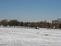
View of Juniper Valley Park in the winter, facing west towards Manhattan.
