
Image: 1884 Drew Pocket Map of Florida - Geographicus - Florida-drew-1884

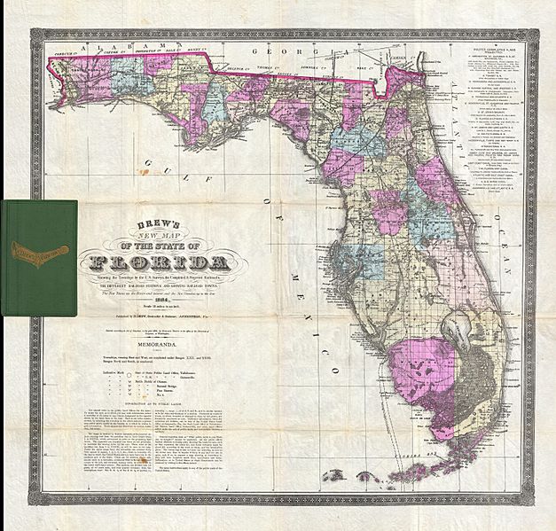
Description: An extremely scarce and important map of Florida drawn by Horace Drew in 1884. This highly uncommon map, the earliest known example of which was issued in 1867, is considered to be the only pocket map of Florida actually printed in Florida. The first edition of this map was printed by Columbus Drew from his offices in Jacksonville Florida and subsequently updated in an unknown number of editions into the 1880s. This example was printed by Horace Drew, son and successor to Columbus. It reflects the rapid and hopeful development of Florida through the middle and late 19 century, with numerous railways, roads, and canals noted. Of particular note is the Lucie Canal, shown here leading from Lake Okeechobee to the Atlantic. This canal was part of a plan, supported by Drew, to drain the Everglades via a series of well placed water channels. Fortunately the Lucie canal was never built and the unique Everglades biosphere has been preserved for us to enjoy today. Also of interest is the extensive notation in the lower left quadrant regarding the Florida Land Survey. Even in the late 19th century much of Florida remained federally administrated Public Land. It was the work of the Florida Land Survey, upon which this map is based, to plat out the land for sale to settlers. Drew's notations explain the process and how do identify land available for purchase. Drew additionally notes the sites of various important battles during the Seminole Wars. Considered the Holy Grail of 19th century Florida cartography, this map is a must for any serious collection focusing on the American Southeast. Dated and copyrighted, Entered according to Act of Congress in the year 1884 by Horace Drew, in the office of the Librarian of Congress, at Washington.
Title: Drew's New Map of the State of Florida Showing the Townships by the U. S. Surveys, the Completed & Projected Railroads, the Different Railroad Stations and Growing Railroad Towns. The New Towns on the Rivers and interior and the New Counties up to the Year 1884.
Credit: This file was provided to Wikimedia Commons by Geographicus Rare Antique Maps, a specialist dealer in rare maps and other cartography of the 15th, 16th, 17th, 18th and 19th centuries, as part of a cooperation project.
Author: http://www.geographicus.com/mm5/cartographers/drew.txt
Permission: Public domain works must be out of copyright in both the United States and in the source country of the work in order to be hosted on the Commons. If the work is not a U.S. work, the file must have an additional copyright tag indicating the copyright status in the source country. PD-1923Public domain in the United States//commons.wikimedia.org/wiki/File:1884_Drew_Pocket_Map_of_Florida_-_Geographicus_-_Florida-drew-1884.jpg
Usage Terms: Public domain
License: Public domain
Attribution Required?: No
Image usage
The following page links to this image:
