
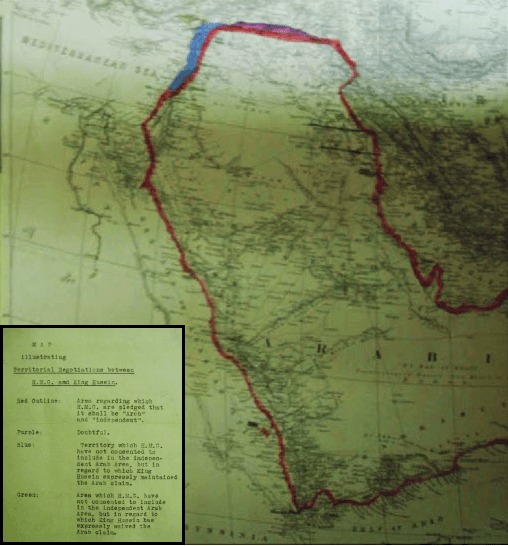
Image: 1918 British Government Map illustrating Territorial Negotiations between H.M.G. and King Hussein
No higher resolution available.
1918_British_Government_Map_illustrating_Territorial_Negotiations_between_H.M.G._and_King_Hussein.png (508 × 546 pixels, file size: 489 KB, MIME type: image/png)
Description: MPK 1/410 extracted from FO 371/4368; (7) Larger printed map, showing additionally the whole Arabian peninsula. Reference table. Scale: 1:6,969,600. Ms additions, coloured, mark several areas under discussion. Title affixed: 'Map illustrating Territorial Negotiations between H.M.G. amd King Hussein'; reference table to additions affixed.
Title: 1918 British Government Map illustrating Territorial Negotiations between H.M.G. and King Hussein
Credit: National Archives: http://discovery.nationalarchives.gov.uk/details/r/C3980431
Author: UK Government
Usage Terms: Public domain
License: Public domain
Attribution Required?: No
Image usage
The following image is a duplicate of this image (more details):
The following 5 pages link to this image:

All content from Kiddle encyclopedia articles (including the article images and facts) can be freely used under Attribution-ShareAlike license, unless stated otherwise.