
Image: 1923 map of Mound bottom
No higher resolution available.
1923_map_of_Mound_bottom.jpg (386 × 258 pixels, file size: 25 KB, MIME type: image/jpeg)
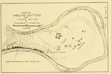
Description: Map of the Mound bottom archaeological site in Cheatham County Tennessee, prepared in 1923 by Crawford C. Anderson. Originally published as Figure 109 by William Edward Myer in "Archaeological Field Work in Tennessee" (Smithsonian Miscellaneous Collections 76-1. Washington, DC: Smithsonian Institution, 1924)
Title: 1923 map of Mound bottom
Credit: https://archive.org/details/cbarchive_48626_archaeologicalfieldworkintenne1862
Author: William Edward Myer
Usage Terms: Fair use of copyrighted material in the context of Mound Bottom
License: Fair use
License Link: //en.wikipedia.org/wiki/File:1923_map_of_Mound_bottom.jpg
Image usage
The following page links to this image:

All content from Kiddle encyclopedia articles (including the article images and facts) can be freely used under Attribution-ShareAlike license, unless stated otherwise.