Mound Bottom facts for kids
Quick facts for kids |
|
|
Mound Bottom
|
|

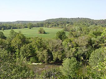
View of the central plaza and platform mound at Mound Bottom, from May's Mace Bluff
|
|
| Location | Cheatham County, Tennessee |
|---|---|
| Built | 950-1300 CE |
| NRHP reference No. | 71000813 |
| Added to NRHP | 1971 |
Mound Bottom is an amazing ancient site built by Native Americans in Cheatham County, Tennessee. It has big earthen mounds (some flat-topped, some for burials), a huge open area called a 7-acre central plaza, and places where people lived. People lived here between about 1000 and 1300 AD, during a time known as the Mississippian period.
Mound Bottom is probably connected to another mound site called the Pack Site. This site is just over a mile south. Together, these two places are sometimes called the "Great Mound Group." Because the mounds and pottery styles are similar, experts believe these sites were used at the same time.
Where is Mound Bottom?
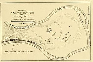
Mound Bottom is located on a horseshoe-shaped bend of the Harpeth River. A smaller stream called Mound Creek also meets the river here. The Harpeth River makes many sharp turns through a steep gorge before joining the Cumberland River. The river surrounds Mound Bottom on three sides: north, south, and east. Rocky hills mark the entrance to the bend from the west.
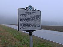
Today, Mound Bottom is about 1 mile (1.6 km) north of where U.S. Route 70 crosses the Harpeth River. It's near Kingston Springs. The Tennessee Department of Environment and Conservation manages the site as part of Harpeth River State Park. You can only visit Mound Bottom with a park ranger or someone from the Tennessee Division of Archaeology. The Pack Site is on private land and is not open to visitors.
What We Know About Mound Bottom's History
Mound Bottom and the Pack Site together have up to 34 earthen mounds. Mound Bottom has between 11 and 14 mounds, and Pack has 20. Some mounds are flat-topped, used for important buildings or homes for leaders. Others were for burials. At Mound Bottom, a large flat-topped mound and up to 13 smaller mounds were built around a central plaza.
The main mound at Mound Bottom was once at least 36 feet (11 meters) tall. Its base was about 246 feet (75 meters) long on each side. People likely reached the top using a ramp or stairs on the eastern side. Early reports say the Mound Bottom complex was surrounded by an earthen wall with a palisade (a fence of upright logs). However, this wall was gone by the 1920s due to farming. Besides the mounds, the site also had hundreds of houses, cemeteries, and farms.
The ancient Native American culture in the Nashville area is now called the Middle Cumberland Mississippian culture. This group built Mound Bottom, Pack, and other mound sites. Archaeologists learned about this culture from their unique burial items and stone box burials.
Experts believe that people from outside the region first settled Mound Bottom and Pack around 1000 AD. They might have come from a place called the American Bottom, possibly even from the famous site of Cahokia. Because of this connection, the Middle Cumberland Culture was part of a larger network of ancient cultures. This network connected groups from the Great Lakes to the Gulf Coast and the Appalachian Mountains.
Around 1350 AD, Mound Bottom and Pack stopped being major centers. People no longer built or repaired mounds, but they still used the sites for burials. This change might mean that the region's central leadership weakened. Smaller, fortified villages became more common. By about 1475 AD, most Mississippian settlements in the area seem to have disappeared.
Mound Bottom in Recent History
In 1823, early Tennessee historian John Haywood wrote about Mound Bottom's importance. Early settlers also reported seeing large walls and towers there. In the late 1860s, Joseph Jones from the Smithsonian Institution studied the site. He described "extraordinary aboriginal works" at Mound Bottom.
In 1923, William E. Myer, also with the Smithsonian, did the first modern study of Mound Bottom. He found signs of a building and a fireplace on top of a mound at the Pack site. He also found evidence of 10 ancient houses at Mound Bottom. In 1926, Tennessee's first State Archaeologist, P.E. Cox, continued this work. He found many stone box burials and baked clay floors.
From 1936 to 1940, the University of Tennessee conducted more excavations at both Mound Bottom and the Pack Site. These digs looked at several cemeteries and a burial mound.
In 1972, the State of Tennessee bought Mound Bottom to protect it as an archaeological area. The Tennessee Division of Archaeology sent Carl Kuttruff and Michael O'Brien to dig there in 1974 and 1975. They studied six mounds and 19 houses. Their findings were published in 2012.
In 2005, Mound Bottom became part of Harpeth River State Park. This park connects several important historical and natural areas along the Harpeth River. The site is usually closed to the public, but you can request guided tours. In 2008, more land next to Mound Bottom was bought to help protect the site.
Mound Bottom and the ancient rock art at May's Mace Bluff inspired the 2014 Tennessee Archaeology Awareness Month poster.
 | William M. Jackson |
 | Juan E. Gilbert |
 | Neil deGrasse Tyson |


